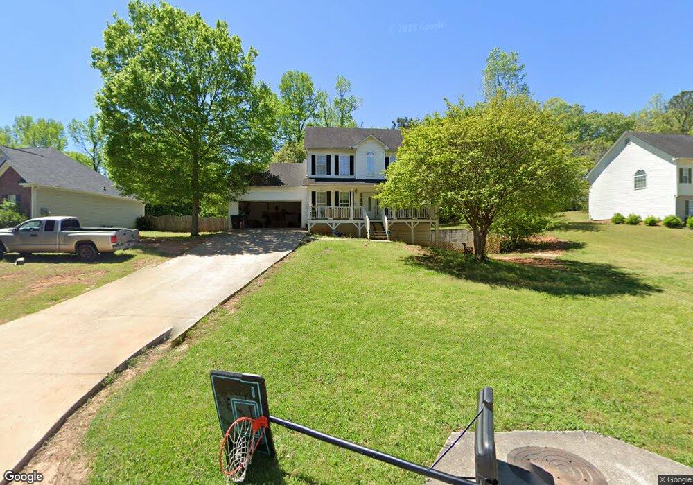
199 Emerald Pointe Dr Carrollton, GA 30116
Abilene NeighborhoodEstimated Value: $255,000 - $274,698
3
Beds
2
Baths
1,474
Sq Ft
$182/Sq Ft
Est. Value
About This Home
This home is located at 199 Emerald Pointe Dr, Carrollton, GA 30116 and is currently estimated at $268,425, approximately $182 per square foot. 199 Emerald Pointe Dr is a home located in Carroll County with nearby schools including Sharp Creek Elementary School, Bay Springs Middle School, and Villa Rica High School.
Ownership History
Date
Name
Owned For
Owner Type
Purchase Details
Closed on
Dec 16, 2011
Sold by
Federal National Mortgage Association
Bought by
Duran Marino
Current Estimated Value
Purchase Details
Closed on
Dec 7, 2010
Sold by
Bac Home Loans Servicing Lp
Bought by
Federal National Mortgage Association
Purchase Details
Closed on
Dec 22, 2003
Sold by
Butler M Kathryn
Bought by
Swint Robbie L
Purchase Details
Closed on
Dec 15, 2003
Sold by
B & M Builders Inc
Bought by
Butler Katheryn
Purchase Details
Closed on
Dec 8, 2003
Sold by
Mulkey Michael L and Bryan Lyn A
Bought by
B & M Builders Inc
Purchase Details
Closed on
Sep 30, 2003
Sold by
B & M Builders Inc
Bought by
Mulkey Michael L and Bryan Lyn A
Purchase Details
Closed on
Oct 3, 2001
Sold by
Jacob Development In
Bought by
B & M Builders Inc
Purchase Details
Closed on
Oct 1, 2000
Bought by
Jacob Development In
Create a Home Valuation Report for This Property
The Home Valuation Report is an in-depth analysis detailing your home's value as well as a comparison with similar homes in the area
Home Values in the Area
Average Home Value in this Area
Purchase History
| Date | Buyer | Sale Price | Title Company |
|---|---|---|---|
| Duran Marino | $71,000 | -- | |
| Federal National Mortgage Association | $127,759 | -- | |
| Bac Home Loans Servicing Lp | $127,759 | -- | |
| Swint Robbie L | -- | -- | |
| Butler Katheryn | $151,000 | -- | |
| B & M Builders Inc | -- | -- | |
| Mulkey Michael L | $138,800 | -- | |
| B & M Builders Inc | $60,000 | -- | |
| Jacob Development In | -- | -- |
Source: Public Records
Tax History
| Year | Tax Paid | Tax Assessment Tax Assessment Total Assessment is a certain percentage of the fair market value that is determined by local assessors to be the total taxable value of land and additions on the property. | Land | Improvement |
|---|---|---|---|---|
| 2025 | $2,238 | $100,046 | $6,000 | $94,046 |
| 2024 | $2,263 | $100,046 | $6,000 | $94,046 |
| 2023 | $2,263 | $91,452 | $6,000 | $85,452 |
| 2022 | $1,871 | $74,598 | $6,000 | $68,598 |
| 2021 | $1,662 | $64,833 | $6,000 | $58,833 |
| 2020 | $1,489 | $57,992 | $6,000 | $51,992 |
| 2019 | $1,390 | $53,732 | $6,000 | $47,732 |
| 2018 | $1,314 | $50,044 | $6,000 | $44,044 |
| 2017 | $1,318 | $50,044 | $6,000 | $44,044 |
| 2016 | $1,319 | $50,044 | $6,000 | $44,044 |
| 2015 | $956 | $34,181 | $6,000 | $28,182 |
| 2014 | $960 | $34,182 | $6,000 | $28,182 |
Source: Public Records
Map
Nearby Homes
- 124 Betty Ln
- 2467 Shady Grove Rd
- 90 Oak Ridge Dr
- 56 Tallahatchee Dr
- 171 Highland Dr
- 555 McKenzie Bridge Rd
- 0 Shady Grove Rd Unit 7734570
- 00 Shady Grove Rd
- 0 Shady Grove Rd Unit 10709609
- 0 Shady Grove Rd Unit 10709664
- 104 Winston Way
- 22 Shadow Hill Dr
- 0 Knight Dr W
- 378 Old Airport Rd
- 825 Frashier Rd
- 10 Deerfield Ln
- 0 Old Airport Rd Unit 10599783
- 0 Old Airport Rd Unit 7642238
- 0 Old Airport Rd Unit 7642301
- 0 Old Airport Rd Unit 7642336
- 199 Emerald
- 211 Emerald Pointe Dr Unit 43
- 211 Emerald Pointe Dr
- 187 Emerald Pointe Dr
- 221 Emerald Pointe Dr
- 120 Betty Ln
- 175 Emerald Pointe Dr
- 116 Betty Ln
- 196 Emerald Pointe Dr
- 186 Emerald Pointe Dr
- 128 Betty Ln
- 231 Emerald Pointe Dr
- 150 Ivory Ln
- 163 Emerald Pointe Dr
- 112 Betty Ln
- 174 Emerald Pointe Dr
- 236 Emerald Pointe Dr
- 135 Ivory Ln
- 237 Emerald Pointe Dr
- 236 Emerald Pointe Dr
Your Personal Tour Guide
Ask me questions while you tour the home.