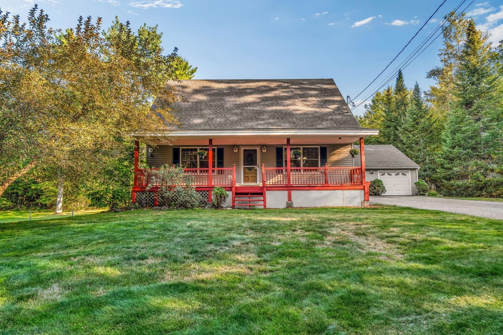


199 West Rd Bowdoin, ME 04287
Estimated payment $2,441/month
Highlights
- Hot Property
- Cape Cod Architecture
- Wood Flooring
- Scenic Views
- Deck
- 1-minute walk to Purinton Homestead Conservation Area
About This Home
Unique opportunity to secure a reduced interest through the List & LockTM program! This seller purchased rate buy-down can significantly reduce your monthly expenses — terms apply, please inquire for full details. Nestled in a serene setting, this charming 3-bedroom home was appraised for 475,000 dollars in March 2025! It offers the perfect blend of privacy, space, and natural beauty. The large, expansive fenced yard is a rare find, complete with mature fruit trees and a peaceful pond, creating your own personal retreat right at home. Whether you're relaxing outdoors, entertaining guests, or simply enjoying the tranquility, this property is designed for comfort and lifestyle.
Listing Agent
Keller Williams Realty Brokerage Phone: 207-576-8771 Listed on: 09/18/2025

Open House Schedule
-
Sunday, September 21, 202511:00 am to 1:00 pm9/21/2025 11:00:00 AM +00:009/21/2025 1:00:00 PM +00:00Add to Calendar
Home Details
Home Type
- Single Family
Est. Annual Taxes
- $3,945
Year Built
- Built in 1998
Lot Details
- 2.8 Acre Lot
- Rural Setting
- Level Lot
- Open Lot
Parking
- 2 Car Detached Garage
- Driveway
Property Views
- Scenic Vista
- Woods
Home Design
- Cape Cod Architecture
- Saltbox Architecture
- Post and Beam
- Concrete Foundation
- Wood Frame Construction
- Shingle Roof
- Vinyl Siding
- Concrete Perimeter Foundation
Interior Spaces
- 1,764 Sq Ft Home
- Living Room
- Dining Room
Kitchen
- Electric Range
- Microwave
- Dishwasher
Flooring
- Wood
- Laminate
- Tile
Bedrooms and Bathrooms
- 3 Bedrooms
- Main Floor Bedroom
Laundry
- Laundry on main level
- Dryer
- Washer
Basement
- Basement Fills Entire Space Under The House
- Interior Basement Entry
Eco-Friendly Details
- Green Energy Fireplace or Wood Stove
Outdoor Features
- Deck
- Patio
- Shed
Utilities
- No Cooling
- Heating System Uses Oil
- Baseboard Heating
- Hot Water Heating System
- Power Generator
- Natural Gas Not Available
- Private Water Source
- Electric Water Heater
- Private Sewer
- Internet Available
- Cable TV Available
Community Details
- No Home Owners Association
Listing and Financial Details
- Tax Lot 07
- Assessor Parcel Number BOWD-000009-000000-000007-000001
Map
Home Values in the Area
Average Home Value in this Area
Tax History
| Year | Tax Paid | Tax Assessment Tax Assessment Total Assessment is a certain percentage of the fair market value that is determined by local assessors to be the total taxable value of land and additions on the property. | Land | Improvement |
|---|---|---|---|---|
| 2024 | $3,836 | $395,500 | $95,800 | $299,700 |
| 2023 | $4,201 | $230,800 | $50,000 | $180,800 |
| 2022 | $4,052 | $239,740 | $50,020 | $189,720 |
| 2021 | $4,128 | $248,660 | $50,020 | $198,640 |
| 2020 | $972 | $248,660 | $50,020 | $198,640 |
| 2019 | $3,968 | $251,110 | $50,020 | $201,090 |
| 2018 | $3,792 | $251,110 | $50,020 | $201,090 |
| 2017 | $3,767 | $251,110 | $50,020 | $201,090 |
| 2016 | $3,691 | $251,110 | $50,020 | $201,090 |
| 2015 | $3,666 | $251,110 | $50,020 | $201,090 |
| 2014 | $3,490 | $251,110 | $50,020 | $201,090 |
| 2013 | $3,264 | $251,110 | $50,020 | $201,090 |
Property History
| Date | Event | Price | Change | Sq Ft Price |
|---|---|---|---|---|
| 09/19/2025 09/19/25 | Pending | -- | -- | -- |
| 09/18/2025 09/18/25 | For Sale | $400,000 | -- | $227 / Sq Ft |
Purchase History
| Date | Type | Sale Price | Title Company |
|---|---|---|---|
| Interfamily Deed Transfer | -- | -- | |
| Warranty Deed | -- | -- |
Mortgage History
| Date | Status | Loan Amount | Loan Type |
|---|---|---|---|
| Open | $203,127 | New Conventional |
Source: Maine Listings
MLS Number: 1638107
APN: BOWD-000009-000000-000007-000001
Disclaimer: Certain information contained herein is derived from information provided by parties other than Homes.com. All information provided is deemed reliable, but is not guaranteed to be accurate and should be independently verified.
![]() Listing data is derived in whole or in part from Maine Real Estate Information System, Inc. (d/b/a Maine Listings) and is for consumers' personal, noncommercial use only. Dimensions are approximate and not guaranteed. All data should be independently verified.
Listing data is derived in whole or in part from Maine Real Estate Information System, Inc. (d/b/a Maine Listings) and is for consumers' personal, noncommercial use only. Dimensions are approximate and not guaranteed. All data should be independently verified.
© 2025 Maine Real Estate Information System, Inc. All Rights Reserved. Equal Housing Opportunity.
Homes.com, LLC, 17600 Laguna Canyon Rd Irvine, CA 92618 (888)-952-6393
![]()
- 105 Pinewood Acres Rd
- 511 Bowdoinham Rd
- 521 Williams Rd
- 549 Litchfield Rd
- 255 Williams Rd
- 25 Litchfield Rd
- 64 Litchfield Rd
- Lot 23 Bowdoinham Rd
- 797 Litchfield Rd
- 338 Lewis Hill Rd
- Lot 49 W Burrough Rd
- 1239 Main St
- 74 E Ridge Rd
- 84 Bowdoin Pines Rd
- 807 Middle Rd
- 153 Dead River Rd
- 1007 West Rd
- 19 Wing St
- 23 Dumas St
- 232 Dead River Rd