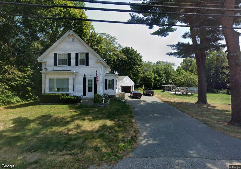
199 Weymouth St Holbrook, MA 02343
Estimated Value: $554,000 - $606,173
3
Beds
1
Bath
1,516
Sq Ft
$383/Sq Ft
Est. Value
About This Home
This home is located at 199 Weymouth St, Holbrook, MA 02343 and is currently estimated at $580,793, approximately $383 per square foot. 199 Weymouth St is a home located in Norfolk County with nearby schools including John F. Kennedy Elementary School, Holbrook Middle High School, and Boston Higashi School.
Ownership History
Date
Name
Owned For
Owner Type
Purchase Details
Closed on
Jul 17, 2025
Sold by
Ross Thomas J and Ross Elizabeth A
Bought by
Ross Rt and Ross
Current Estimated Value
Purchase Details
Closed on
Aug 4, 1994
Sold by
Ross Tina M and Ross Tracey J
Bought by
Ross Thomas J and Ross Elizabeth
Create a Home Valuation Report for This Property
The Home Valuation Report is an in-depth analysis detailing your home's value as well as a comparison with similar homes in the area
Home Values in the Area
Average Home Value in this Area
Purchase History
| Date | Buyer | Sale Price | Title Company |
|---|---|---|---|
| Ross Rt | -- | -- | |
| Ross Rt | -- | -- | |
| Ross Thomas J | $78,666 | -- | |
| Ross Thomas J | $78,666 | -- | |
| Ross Thomas J | $78,666 | -- | |
| Ross Thomas J | $78,666 | -- |
Source: Public Records
Mortgage History
| Date | Status | Borrower | Loan Amount |
|---|---|---|---|
| Previous Owner | Ross Thomas J | $20,000 | |
| Previous Owner | Ross Marie E | $115,700 |
Source: Public Records
Tax History Compared to Growth
Tax History
| Year | Tax Paid | Tax Assessment Tax Assessment Total Assessment is a certain percentage of the fair market value that is determined by local assessors to be the total taxable value of land and additions on the property. | Land | Improvement |
|---|---|---|---|---|
| 2025 | $69 | $520,200 | $276,500 | $243,700 |
| 2024 | $6,414 | $477,200 | $251,400 | $225,800 |
| 2023 | $6,819 | $443,400 | $229,900 | $213,500 |
| 2022 | $6,441 | $390,600 | $201,700 | $188,900 |
| 2021 | $6,328 | $367,500 | $189,500 | $178,000 |
| 2020 | $6,448 | $351,000 | $179,900 | $171,100 |
| 2019 | $6,505 | $334,300 | $167,400 | $166,900 |
| 2018 | $6,360 | $307,700 | $146,300 | $161,400 |
| 2017 | $6,260 | $299,500 | $146,300 | $153,200 |
| 2016 | $5,381 | $274,000 | $133,100 | $140,900 |
| 2015 | $5,033 | $263,800 | $128,300 | $135,500 |
| 2014 | $4,952 | $263,800 | $128,300 | $135,500 |
Source: Public Records
Map
Nearby Homes
- 141 Pond St
- 289 Weymouth St
- 132 Pine St
- 169 Pond St
- 20 Roger Rd
- 360 Plymouth St
- 278 Sycamore St
- 674 Plymouth St
- 373 N Franklin St
- 181 S Franklin St Unit 207
- 129 Albee Dr
- 20 Albee Dr
- 2 Dalton Terrace
- 109 Bradford Commons Ln
- 35 Rindone St
- 5 Clarendon Cir Unit Lot 4
- 86 Bradford Commons Ln
- 375 S Franklin St Unit 1
- 3A-3 Bradford Commons Ln
- 56 Bradford Commons Ln Unit 56
- 199 Weymouth St
- 199 Weymouth St
- 199 Weymouth St
- 199 Weymouth St
- 199 Weymouth St
- 201 Weymouth St
- 41 Sycamore St
- 14 Sherrick Ave
- 12 Sherrick Ave
- 180 Weymouth St
- 202 Weymouth St
- 10 Sherrick Ave
- 176 Weymouth St
- 16 Sherrick Ave
- 181 Weymouth St
- 19 Sherrick Ave
- 8 Pine St
- lot 5 Sycamore St
- 1 Sycamore St
- 221 Weymouth St