Estimated Value: $415,268 - $475,000
3
Beds
3
Baths
2,750
Sq Ft
$159/Sq Ft
Est. Value
About This Home
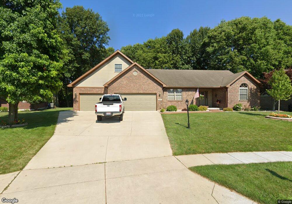
This home is located at 1990 Kitty Hawk Dr, Xenia, OH 45385 and is currently estimated at $436,317, approximately $158 per square foot. 1990 Kitty Hawk Dr is a home located in Greene County with nearby schools including Xenia High School, Summit Academy Community School for Alternative Learners - Xenia, and Legacy Christian Academy.
Ownership History
Date
Name
Owned For
Owner Type
Purchase Details
Closed on
Jul 6, 2000
Sold by
P F D Development Pll
Bought by
Sease Marvin T and Sease Kimberly S
Current Estimated Value
Home Financials for this Owner
Home Financials are based on the most recent Mortgage that was taken out on this home.
Original Mortgage
$110,000
Interest Rate
8.12%
Create a Home Valuation Report for This Property
The Home Valuation Report is an in-depth analysis detailing your home's value as well as a comparison with similar homes in the area
Home Values in the Area
Average Home Value in this Area
Purchase History
| Date | Buyer | Sale Price | Title Company |
|---|---|---|---|
| Sease Marvin T | $41,000 | -- |
Source: Public Records
Mortgage History
| Date | Status | Borrower | Loan Amount |
|---|---|---|---|
| Closed | Sease Marvin T | $110,000 |
Source: Public Records
Tax History Compared to Growth
Tax History
| Year | Tax Paid | Tax Assessment Tax Assessment Total Assessment is a certain percentage of the fair market value that is determined by local assessors to be the total taxable value of land and additions on the property. | Land | Improvement |
|---|---|---|---|---|
| 2024 | $4,763 | $124,050 | $21,160 | $102,890 |
| 2023 | $4,763 | $124,050 | $21,160 | $102,890 |
| 2022 | $4,162 | $93,850 | $14,110 | $79,740 |
| 2021 | $4,218 | $93,850 | $14,110 | $79,740 |
| 2020 | $4,338 | $93,850 | $14,110 | $79,740 |
| 2019 | $4,338 | $94,840 | $18,110 | $76,730 |
| 2018 | $4,355 | $94,840 | $18,110 | $76,730 |
| 2017 | $4,131 | $94,840 | $18,110 | $76,730 |
| 2016 | $4,132 | $88,930 | $18,110 | $70,820 |
| 2015 | $4,143 | $88,930 | $18,110 | $70,820 |
| 2014 | $3,963 | $88,930 | $18,110 | $70,820 |
Source: Public Records
Map
Nearby Homes
- 2144 Tandem Dr
- 2223 Tandem Dr
- 2096 High Wheel Dr
- 2540 Cornwall Dr
- 2540 Jenny Marie Dr
- 0 Berkshire Dr Unit 942854
- 2499 Jenny Marie Dr
- 2421 Louisiana Dr
- 2187 Minnesota Dr
- 1255 Colorado Dr
- 2265 Minnesota Dr
- 1881 Commonwealth Dr
- 2821 Raxit Ct
- 2852 Raxit Ct
- 1908 Whitt St
- 2189 Mississippi Dr
- 2685 Childers Dr
- 1068 Hedges Rd
- 2705 Tennessee Dr
- 1248 Prem Place
- 1980 Kitty Hawk Dr
- 2000 Kitty Hawk Dr
- 1970 Kitty Hawk Dr
- 1989 Kitty Hawk Dr
- 2010 Kitty Hawk Dr
- 2020 Kitty Hawk Dr
- 2029 Kitty Hawk Dr
- 1959 Kitty Hawk Dr
- 1978 Lakeview Dr
- 1950 Kitty Hawk Dr
- lot # 206 Kitty Hawk Dr
- 1968 Lakeview Dr
- 2030 Kitty Hawk Dr
- 1949 Kitty Hawk Dr
- 1958 Lakeview Dr
- 1940 Kitty Hawk Dr
- 2040 Kitty Hawk Dr
- 1939 Kitty Hawk Dr
- 1948 Lakeview Dr
- 1969 Lakeview Dr