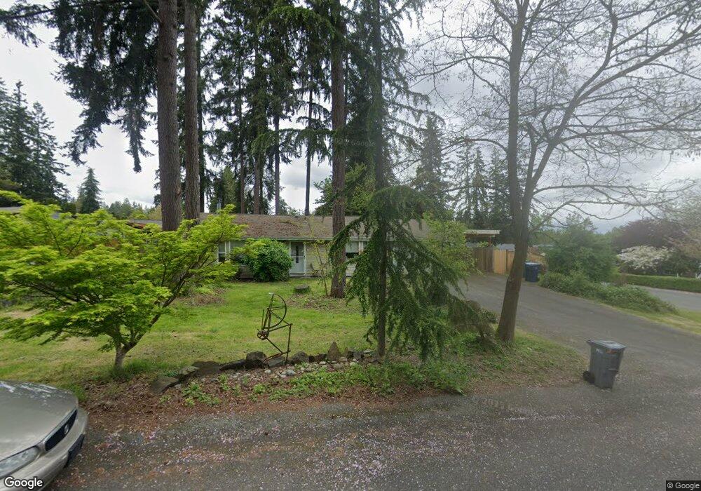
19904 10th Dr SE Bothell, WA 98012
Queensborough-Brentwood NeighborhoodEstimated Value: $674,000 - $835,000
3
Beds
1
Bath
1,368
Sq Ft
$548/Sq Ft
Est. Value
About This Home
This home is located at 19904 10th Dr SE, Bothell, WA 98012 and is currently estimated at $750,346, approximately $548 per square foot. 19904 10th Dr SE is a home located in Snohomish County with nearby schools including Crystal Springs Elementary School, Canyon Park Junior High School, and Bothell High School.
Ownership History
Date
Name
Owned For
Owner Type
Purchase Details
Closed on
Dec 6, 2019
Sold by
Dodson Magnus Kathryn S and Kathryn S Dodson Magnus Living
Bought by
Cuthbert Dana D
Current Estimated Value
Home Financials for this Owner
Home Financials are based on the most recent Mortgage that was taken out on this home.
Original Mortgage
$330,400
Outstanding Balance
$291,295
Interest Rate
3.6%
Mortgage Type
New Conventional
Estimated Equity
$459,051
Purchase Details
Closed on
Dec 6, 1999
Sold by
Dodson Magnus Kay S and Dodson Magnus Kathryn S
Bought by
Dodson Magnus Kathryn S and Kathryn S Dodson Magnus Living
Purchase Details
Closed on
Aug 10, 1999
Sold by
Andrews Joseph C and Andrews Elaine B
Bought by
Dodson Magnus Kay S
Home Financials for this Owner
Home Financials are based on the most recent Mortgage that was taken out on this home.
Original Mortgage
$95,000
Interest Rate
7.7%
Create a Home Valuation Report for This Property
The Home Valuation Report is an in-depth analysis detailing your home's value as well as a comparison with similar homes in the area
Home Values in the Area
Average Home Value in this Area
Purchase History
| Date | Buyer | Sale Price | Title Company |
|---|---|---|---|
| Cuthbert Dana D | $413,000 | First American Title Ins Co | |
| Dodson Magnus Kathryn S | -- | -- | |
| Dodson Magnus Kay S | $140,000 | -- |
Source: Public Records
Mortgage History
| Date | Status | Borrower | Loan Amount |
|---|---|---|---|
| Open | Cuthbert Dana D | $330,400 | |
| Previous Owner | Dodson Magnus Kay S | $95,000 |
Source: Public Records
Tax History
| Year | Tax Paid | Tax Assessment Tax Assessment Total Assessment is a certain percentage of the fair market value that is determined by local assessors to be the total taxable value of land and additions on the property. | Land | Improvement |
|---|---|---|---|---|
| 2025 | $5,342 | $638,800 | $490,000 | $148,800 |
| 2024 | $5,342 | $632,900 | $480,000 | $152,900 |
| 2023 | $5,448 | $703,400 | $530,000 | $173,400 |
| 2022 | $5,000 | $516,300 | $369,000 | $147,300 |
| 2020 | $4,500 | $431,900 | $281,000 | $150,900 |
| 2019 | $3,884 | $381,100 | $240,000 | $141,100 |
| 2018 | $3,597 | $332,400 | $205,000 | $127,400 |
| 2017 | $2,986 | $282,500 | $165,000 | $117,500 |
| 2016 | $2,859 | $261,800 | $149,000 | $112,800 |
Source: Public Records
Map
Nearby Homes
- 19921 10th Dr SE
- 1126 199th St SE
- 1216 199th St SE
- 727 198th Place SE
- 20224 11th Dr SE
- 820 Grimes Rd
- 20029 7th Ave SE
- 20511 Greening Rd
- 1402 194th St SE Unit 1
- 429 203rd Place SE
- 1322 194th St SE Unit B4
- 1322 194th St SE Unit B7
- 1322 194th St SE Unit B2
- 1322 194th St SE Unit B1
- 1322 194th St SE Unit B6
- 20318 Bothell Everett Hwy Unit A303
- 1820 201st Place SE
- 603 194th Place SE
- 1332 192nd St SE Unit 50
- 1615 208th St SE Unit 42
- 19908 10th Dr SE
- 19826 10th Dr SE
- 19822 10th Dr SE
- 19905 10th Dr SE
- 19922 10th Dr SE
- 19913 10th Dr SE
- 19831 10th Dr SE
- 19910 10th Dr SE
- 19932 10th Dr SE
- 19818 10th Dr SE
- 19823 10th Dr SE
- 19914 10th Dr SE
- 19928 10th Dr SE
- 19806 10th Dr SE
- 19929 10th Dr SE
- 19828 11th Dr SE Unit ARV32
- 19826 11th Dr SE Unit Lot31
- 19918 10th Dr SE
- 19815 10th Dr SE
- 19824 11th Dr SE
Your Personal Tour Guide
Ask me questions while you tour the home.