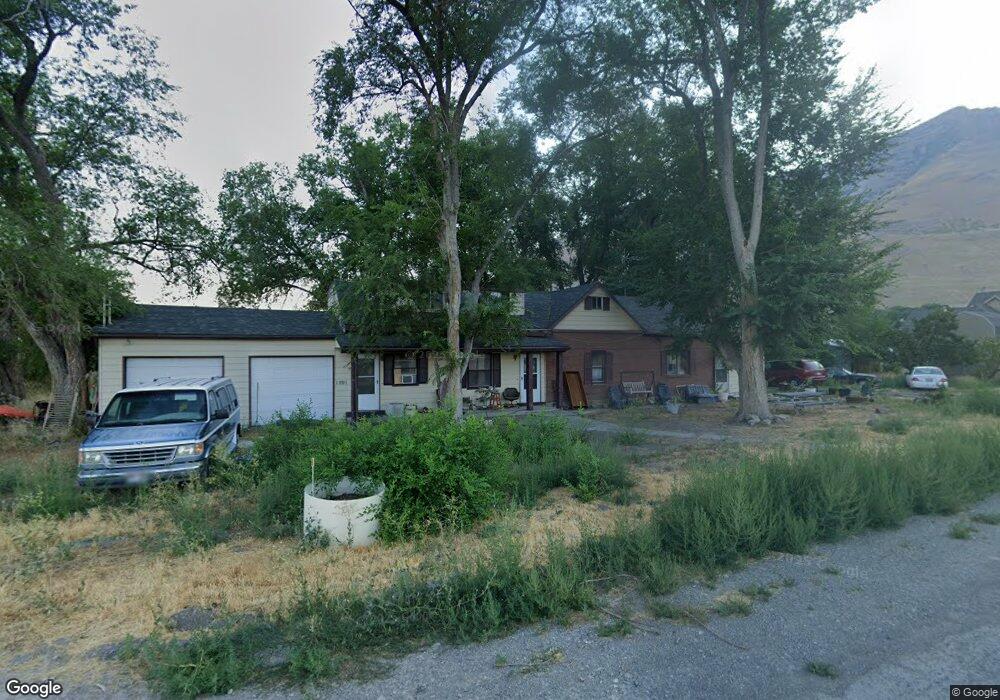
1991 Pheasant Ln Tooele, UT 84074
Estimated Value: $554,000 - $663,000
4
Beds
2
Baths
2,654
Sq Ft
$233/Sq Ft
Est. Value
About This Home
This home is located at 1991 Pheasant Ln, Tooele, UT 84074 and is currently estimated at $617,882, approximately $232 per square foot. 1991 Pheasant Ln is a home located in Tooele County with nearby schools including Old Mill Elementary School, Clarke N. Johnsen Junior High School, and Stansbury High School.
Ownership History
Date
Name
Owned For
Owner Type
Purchase Details
Closed on
Oct 31, 2007
Sold by
Lauritzen Richard D and Lauritzen Sharon A
Bought by
Lauritzen Sharon A
Current Estimated Value
Create a Home Valuation Report for This Property
The Home Valuation Report is an in-depth analysis detailing your home's value as well as a comparison with similar homes in the area
Home Values in the Area
Average Home Value in this Area
Purchase History
| Date | Buyer | Sale Price | Title Company |
|---|---|---|---|
| Lauritzen Sharon A | -- | None Available |
Source: Public Records
Tax History Compared to Growth
Tax History
| Year | Tax Paid | Tax Assessment Tax Assessment Total Assessment is a certain percentage of the fair market value that is determined by local assessors to be the total taxable value of land and additions on the property. | Land | Improvement |
|---|---|---|---|---|
| 2025 | $3,463 | $532,713 | $223,000 | $309,713 |
| 2024 | $3,815 | $297,088 | $124,000 | $173,088 |
| 2023 | $3,815 | $298,158 | $143,250 | $154,908 |
| 2022 | $3,646 | $322,290 | $168,000 | $154,290 |
| 2021 | $3,318 | $245,482 | $74,500 | $170,982 |
| 2020 | $3,200 | $413,992 | $102,400 | $311,592 |
| 2019 | $2,642 | $337,934 | $102,400 | $235,534 |
| 2018 | $2,314 | $278,417 | $77,400 | $201,017 |
| 2017 | $1,961 | $252,210 | $77,400 | $174,810 |
| 2016 | $1,881 | $135,265 | $43,650 | $91,615 |
| 2015 | $1,881 | $135,265 | $0 | $0 |
| 2014 | -- | $135,265 | $0 | $0 |
Source: Public Records
Map
Nearby Homes
- 1991 E Burger St Unit 1241
- 1991 E Burger St
- 2003 E Burger St Unit 1242
- 2003 E Burger St
- 1971 E Burger St
- 1971 E Burger St Unit 1239
- 2029 E Burger St
- 2041 E Burger St Unit 1245
- 2041 E Burger St
- 1835 E Burger St Unit 1419
- 1921 E Burger St Unit 1418
- 1992 E Burger St Unit 1234
- 1992 E Burger St
- 2018 E Burger St
- 2018 E Burger St Unit 1232
- 2065 E Burger St Unit 1247
- 2065 E Burger St
- 2090 E Burger St Unit 1244
- 1885 E Burger St Unit 1415
- 8675 N Halloran Ct Unit 1326
- 2021 Pheasant Ln
- 2045 Pheasant Ln
- 1947 E Burger St
- 1913 Pheasant Ln
- 2004 E Burger St
- 2032 E Burger St
- 1946 E Burger St
- 2005 E Antonio Dr
- 1981 E Antonio Dr
- 2017 Antonio Dr Unit 1226
- 2057 E Antonio Dr
- 2047 Antonio Dr
- 1889 Pheasant Ln
- 1581 Pheasant Ln
- 1947 Antonio Dr
- 2086 Antonio Dr Unit 1205
- 1994 E Antonio Dr
- 1982 Antonio Dr
- 1982 Antonio Dr Unit 1218
- 2084 E Antonio Dr