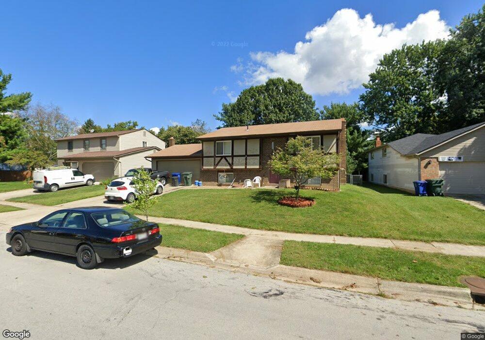
1992 Queensbridge Dr Columbus, OH 43235
Brookside Colony NeighborhoodEstimated Value: $309,000 - $351,000
4
Beds
2
Baths
1,497
Sq Ft
$222/Sq Ft
Est. Value
About This Home
This home is located at 1992 Queensbridge Dr, Columbus, OH 43235 and is currently estimated at $332,070, approximately $221 per square foot. 1992 Queensbridge Dr is a home located in Franklin County with nearby schools including Granby Elementary School, McCord Middle School, and Worthington Kilbourne High School.
Ownership History
Date
Name
Owned For
Owner Type
Purchase Details
Closed on
Apr 7, 2000
Sold by
Woo Anton J and Woo Angela P
Bought by
Swisher Ronald A and Swisher Franciska J
Current Estimated Value
Home Financials for this Owner
Home Financials are based on the most recent Mortgage that was taken out on this home.
Original Mortgage
$111,065
Outstanding Balance
$35,949
Interest Rate
8.31%
Estimated Equity
$296,121
Purchase Details
Closed on
Jun 5, 1996
Sold by
Lewis Donald C
Bought by
Woo Anton J and Woo Angela P
Home Financials for this Owner
Home Financials are based on the most recent Mortgage that was taken out on this home.
Original Mortgage
$99,080
Interest Rate
7.97%
Mortgage Type
FHA
Create a Home Valuation Report for This Property
The Home Valuation Report is an in-depth analysis detailing your home's value as well as a comparison with similar homes in the area
Home Values in the Area
Average Home Value in this Area
Purchase History
| Date | Buyer | Sale Price | Title Company |
|---|---|---|---|
| Swisher Ronald A | $114,500 | Connor Title Co | |
| Woo Anton J | $99,700 | -- |
Source: Public Records
Mortgage History
| Date | Status | Borrower | Loan Amount |
|---|---|---|---|
| Open | Swisher Ronald A | $111,065 | |
| Closed | Woo Anton J | $99,080 |
Source: Public Records
Tax History
| Year | Tax Paid | Tax Assessment Tax Assessment Total Assessment is a certain percentage of the fair market value that is determined by local assessors to be the total taxable value of land and additions on the property. | Land | Improvement |
|---|---|---|---|---|
| 2025 | $5,508 | $89,710 | $24,570 | $65,140 |
| 2024 | $5,508 | $89,710 | $24,570 | $65,140 |
| 2023 | $5,267 | $89,705 | $24,570 | $65,135 |
| 2022 | $4,783 | $64,650 | $19,180 | $45,470 |
| 2021 | $4,413 | $64,650 | $19,180 | $45,470 |
| 2020 | $4,251 | $64,650 | $19,180 | $45,470 |
| 2019 | $3,900 | $53,520 | $15,960 | $37,560 |
| 2018 | $3,638 | $53,520 | $15,960 | $37,560 |
| 2017 | $3,495 | $53,520 | $15,960 | $37,560 |
| 2016 | $3,499 | $49,280 | $14,210 | $35,070 |
| 2015 | $3,499 | $49,280 | $14,210 | $35,070 |
| 2014 | $3,498 | $49,280 | $14,210 | $35,070 |
| 2013 | $1,740 | $49,280 | $14,210 | $35,070 |
Source: Public Records
Map
Nearby Homes
- 7034 Rockhaven Place
- 1978 Shallowford Ave
- 2062 Decker Ct
- 7456 Mapleleaf Ct
- 2001 Sawbury Blvd Unit 2001
- 2026 Sawbury Blvd
- 2024 Sawbury Blvd
- 7370 Coldstream Dr
- 6747 Merwin Rd
- 2074 Hard Rd
- 7735 Schoolway Ct
- 1760 Fallhaven Dr
- 2456 Sanford Dr
- 2469 Sandstrom Dr
- 7965 Boothbay Ct Unit 20
- 7480 Gardenview Place
- 6637 Merwin Rd
- 7164 Durness Place
- 2487 Timbers Edge Ln Unit 2487
- 1354 Lorine Place
- 1986 Queensbridge Dr
- 2000 Queensbridge Dr
- 1978 Queensbridge Dr
- 2001 Shallowford Ave
- 7017 Rockhaven Place
- 1989 Shallowford Ave
- 2010 Queensbridge Dr
- 2009 Queensbridge Dr
- 1970 Queensbridge Dr
- 2017 Queensbridge Dr
- 1999 Queensbridge Dr
- 1991 Queensbridge Dr
- 7020 Rockhaven Place
- 1960 Queensbridge Dr
- 1983 Queensbridge Dr
- 2007 Fincastle Ct
- 2023 Queensbridge Dr
- 6979 Archer St
- 2030 Fincastle Ct
- 2015 Fincastle Ct
Your Personal Tour Guide
Ask me questions while you tour the home.