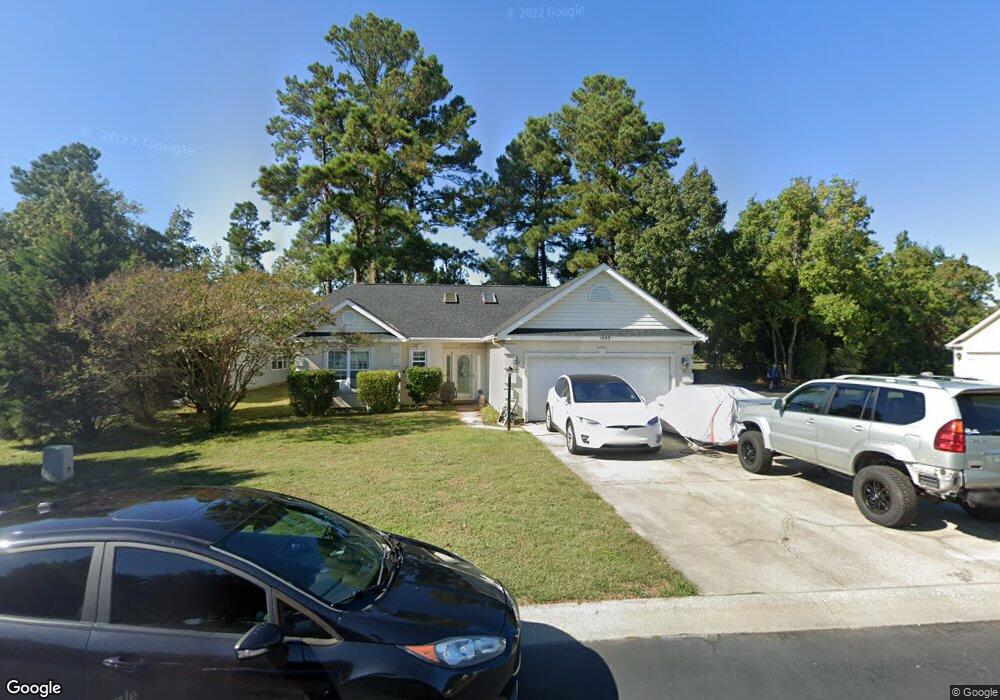
1993 Tree Cir Unit SB Myrtle Beach, SC 29575
Estimated Value: $312,236 - $365,000
3
Beds
2
Baths
1,526
Sq Ft
$214/Sq Ft
Est. Value
About This Home
This home is located at 1993 Tree Cir Unit SB, Myrtle Beach, SC 29575 and is currently estimated at $327,059, approximately $214 per square foot. 1993 Tree Cir Unit SB is a home located in Horry County with nearby schools including Lakewood Elementary, Socastee Middle, and Socastee High School.
Ownership History
Date
Name
Owned For
Owner Type
Purchase Details
Closed on
Sep 23, 2005
Sold by
Laor Bowden Laiad J and Laor Ambrose
Bought by
Laor Bowden Laiad J and Laor Ambrose
Current Estimated Value
Purchase Details
Closed on
Sep 22, 2005
Sold by
Walters Jimmy L
Bought by
Laor Bowden Laiad J and Laor Ambrose
Purchase Details
Closed on
Jul 22, 2003
Sold by
Carson Ernest and Carson Saundra B
Bought by
Walters Jimmy L
Home Financials for this Owner
Home Financials are based on the most recent Mortgage that was taken out on this home.
Original Mortgage
$138,000
Interest Rate
5.24%
Mortgage Type
VA
Purchase Details
Closed on
Jul 9, 1998
Sold by
Dawol Homes Inc
Bought by
Carson Ernest and Carson Saundra B
Home Financials for this Owner
Home Financials are based on the most recent Mortgage that was taken out on this home.
Original Mortgage
$117,250
Interest Rate
7.02%
Mortgage Type
Purchase Money Mortgage
Create a Home Valuation Report for This Property
The Home Valuation Report is an in-depth analysis detailing your home's value as well as a comparison with similar homes in the area
Home Values in the Area
Average Home Value in this Area
Purchase History
| Date | Buyer | Sale Price | Title Company |
|---|---|---|---|
| Laor Bowden Laiad J | -- | -- | |
| Laor Bowden Laiad J | $195,000 | -- | |
| Walters Jimmy L | $138,000 | -- | |
| Carson Ernest | $130,336 | -- |
Source: Public Records
Mortgage History
| Date | Status | Borrower | Loan Amount |
|---|---|---|---|
| Previous Owner | Walters Jimmy L | $138,000 | |
| Previous Owner | Carson Ernest | $117,250 |
Source: Public Records
Tax History
| Year | Tax Paid | Tax Assessment Tax Assessment Total Assessment is a certain percentage of the fair market value that is determined by local assessors to be the total taxable value of land and additions on the property. | Land | Improvement |
|---|---|---|---|---|
| 2025 | $655 | $0 | $0 | $0 |
| 2024 | $655 | $11,022 | $4,063 | $6,959 |
| 2023 | $655 | $5,351 | $1,339 | $4,012 |
| 2021 | $596 | $8,026 | $2,008 | $6,018 |
| 2020 | $1,691 | $8,026 | $2,008 | $6,018 |
| 2019 | $1,691 | $8,026 | $2,008 | $6,018 |
| 2018 | $1,686 | $7,720 | $2,008 | $5,712 |
| 2017 | $0 | $7,720 | $2,008 | $5,712 |
| 2016 | $0 | $7,720 | $2,008 | $5,712 |
| 2015 | -- | $7,721 | $2,009 | $5,712 |
| 2014 | $1,616 | $7,721 | $2,009 | $5,712 |
Source: Public Records
Map
Nearby Homes
- 155 Marsh Deer Place
- 483 Deerfield Links Dr
- 480 Deerfield Links Dr
- 455 Deerfield Links Dr
- 1890 Colony Dr Unit 16-I
- 1890 Colony Dr Unit 17L
- 1890 Colony Dr Unit 18-C
- 1880 Colony Dr Unit 11-R
- 1890 Colony Dr Unit 16-D
- 1880 Colony Dr Unit 11-O
- 1890 Colony Dr Unit 17T
- 1891 Colony Dr Unit 15 E
- 1891 Colony Dr Unit 13D
- 1851 Fairway Ridge Dr Unit 7E
- 1840 Fairway Ridge Dr Unit 8F
- 1809 Platt Blvd
- 1920 Bent Grass Dr Unit 34-I
- 1920 Bent Grass Dr Unit 35-i
- 1920 Bent Grass Dr Unit 35 O
- 1890 Auburn Ln Unit 33D
- 1987 Tree Cir
- 496 Deerfield Links Dr
- 1981 Tree Cir
- 1974 Tree Cir
- 1970 Tree Cir
- 492 Deerfield Links Dr Unit 492
- 492 Deerfield Links Dr
- 1966 Tree Cir Unit Ashley Meadows
- 1966 Tree Cir Unit Ashely Meadows
- 1966 Tree Cir Unit SB
- 1966 Tree Cir
- 1975 Tree Cir
- 1960 Tree Cir
- 1963 Tree Cir
- 1955 Tree Cir
- 1957 Tree Cir Unit Lot 10 Bl B Ashley M
- 1954 Tree Cir Unit Ashley Meadows
- 1954 Tree Cir Unit SB
- 1956 Tree Cir
- 483 Deerfield Links Dr Unit 483
Your Personal Tour Guide
Ask me questions while you tour the home.