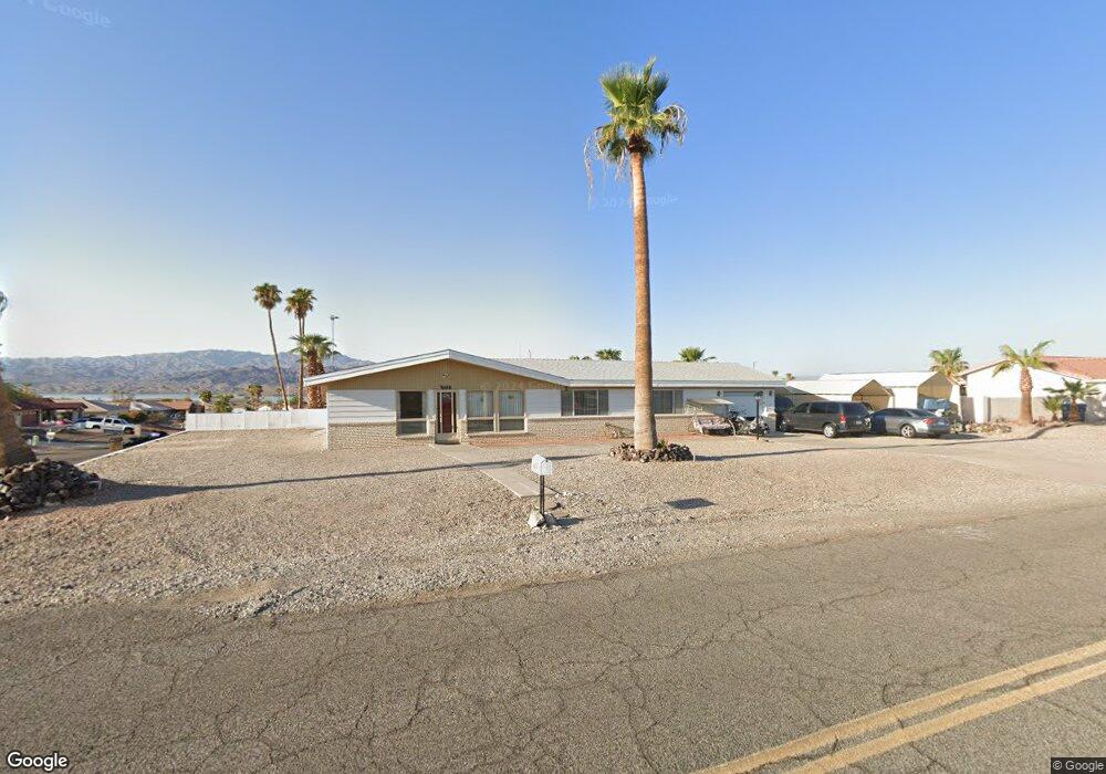
1994 Daytona Ave Lake Havasu City, AZ 86403
Estimated Value: $344,327 - $465,000
3
Beds
2
Baths
1,456
Sq Ft
$262/Sq Ft
Est. Value
About This Home
This home is located at 1994 Daytona Ave, Lake Havasu City, AZ 86403 and is currently estimated at $381,582, approximately $262 per square foot. 1994 Daytona Ave is a home located in Mohave County with nearby schools including Starline Elementary School, Thunderbolt Middle School, and Lake Havasu High School.
Ownership History
Date
Name
Owned For
Owner Type
Purchase Details
Closed on
Oct 19, 2004
Sold by
Lowe Maxine E
Bought by
Gariepy Gilles
Current Estimated Value
Purchase Details
Closed on
Feb 7, 2002
Sold by
Vorac Robert E and Vorac Jane T
Bought by
Lowe John S and Lowe Maxine E
Home Financials for this Owner
Home Financials are based on the most recent Mortgage that was taken out on this home.
Original Mortgage
$87,400
Interest Rate
6.8%
Purchase Details
Closed on
Mar 20, 2000
Sold by
Vorac Jane T
Bought by
Vorac Robert E and Vorac Jane T
Create a Home Valuation Report for This Property
The Home Valuation Report is an in-depth analysis detailing your home's value as well as a comparison with similar homes in the area
Home Values in the Area
Average Home Value in this Area
Purchase History
| Date | Buyer | Sale Price | Title Company |
|---|---|---|---|
| Gariepy Gilles | $160,000 | First American Title Ins Co | |
| Lowe John S | $92,900 | Transnation Title Insurance | |
| Vorac Robert E | -- | -- |
Source: Public Records
Mortgage History
| Date | Status | Borrower | Loan Amount |
|---|---|---|---|
| Previous Owner | Lowe John S | $87,400 |
Source: Public Records
Tax History Compared to Growth
Tax History
| Year | Tax Paid | Tax Assessment Tax Assessment Total Assessment is a certain percentage of the fair market value that is determined by local assessors to be the total taxable value of land and additions on the property. | Land | Improvement |
|---|---|---|---|---|
| 2026 | -- | -- | -- | -- |
| 2025 | $220 | $20,317 | $0 | $0 |
| 2024 | $220 | $34,099 | $0 | $0 |
| 2023 | $220 | $22,224 | $0 | $0 |
| 2022 | $235 | $19,737 | $0 | $0 |
| 2021 | $398 | $15,480 | $0 | $0 |
| 2019 | $421 | $13,540 | $0 | $0 |
| 2018 | $430 | $12,960 | $0 | $0 |
| 2017 | $444 | $11,930 | $0 | $0 |
| 2016 | $423 | $9,988 | $0 | $0 |
| 2015 | $405 | $9,402 | $0 | $0 |
Source: Public Records
Map
Nearby Homes
- 220 White Oak Dr
- 371 Cottonwood Dr
- 190 Aspen Dr
- 160 Aspen Dr
- 1827 Combat Dr
- 1958 Montana Vista Unit D
- 1852 Montana Vista Unit B
- 1884 Montana Vista Unit 63B
- 1840 Montana Vista Unit D
- 1838 Montana Vista Unit C
- 1824 Montana Vista Unit D
- 1962 Cliffrose Dr
- 1793 Montana Vista Unit C
- 100 Mulberry Ave Unit 210
- 100 Mulberry Ave Unit 113
- 2080 Swanson Ave Unit F
- 2080 Swanson Ave Unit C
- 2080 Swanson Ave Unit D
- 2080 Swanson Ave Unit I
- 1786 Los Lagos Dr Unit A
- 211 White Oak Dr
- 1984 Daytona Ave
- 221 White Oak Dr
- 1973 Cottonwood Plaza
- 210 White Oak Dr
- 1971 Cottonwood Plaza
- 231 White Oak Dr
- 1974 Daytona Ave
- 230 White Oak Dr
- 2010 Daytona Ave
- 360 Cottonwood Dr
- 215 Mulberry Ave
- 241 White Oak Dr
- 1964 Daytona Ave
- 1969 Cottonwood Plaza
- 229 Mulberry Ave
- 240 White Oak Dr
- 1967 Cottonwood Plaza
- 48/50 Mulberry Ave
- 48/54 Mulberry Ave