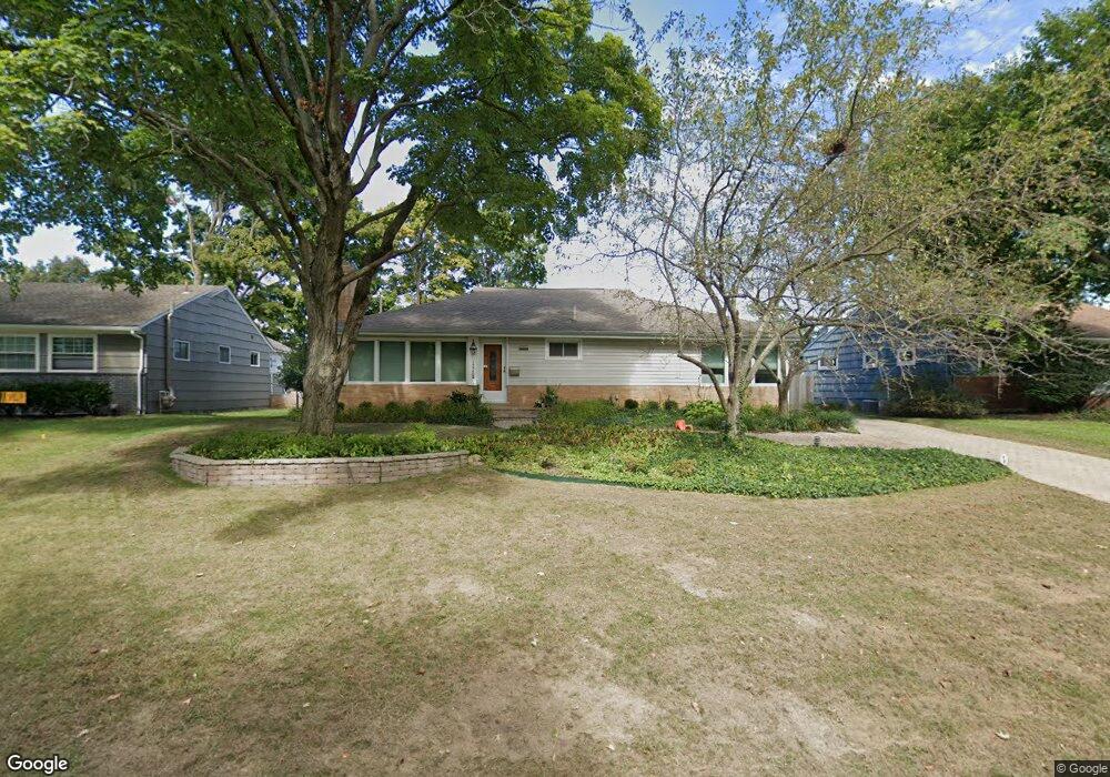
1994 Langham Rd Columbus, OH 43221
Estimated Value: $529,000 - $557,343
3
Beds
2
Baths
1,850
Sq Ft
$294/Sq Ft
Est. Value
About This Home
This home is located at 1994 Langham Rd, Columbus, OH 43221 and is currently estimated at $543,836, approximately $293 per square foot. 1994 Langham Rd is a home located in Franklin County with nearby schools including Tremont Elementary School, Jones Middle School, and Upper Arlington High School.
Ownership History
Date
Name
Owned For
Owner Type
Purchase Details
Closed on
Feb 8, 1991
Bought by
Downey Michael D
Current Estimated Value
Purchase Details
Closed on
Jun 1, 1987
Purchase Details
Closed on
Nov 1, 1984
Create a Home Valuation Report for This Property
The Home Valuation Report is an in-depth analysis detailing your home's value as well as a comparison with similar homes in the area
Home Values in the Area
Average Home Value in this Area
Purchase History
We collect this data history from publicly available records. To have your information removed, we recommend requesting removal directly through your county’s website.
| Date | Buyer | Sale Price | Title Company |
|---|---|---|---|
| Downey Michael D | -- | -- | |
| -- | $66,900 | -- | |
| -- | $65,000 | -- |
Source: Public Records
Tax History
| Year | Tax Paid | Tax Assessment Tax Assessment Total Assessment is a certain percentage of the fair market value that is determined by local assessors to be the total taxable value of land and additions on the property. | Land | Improvement |
|---|---|---|---|---|
| 2025 | $7,769 | $134,190 | $55,790 | $78,400 |
| 2024 | $7,769 | $134,190 | $55,790 | $78,400 |
| 2023 | $7,847 | $134,190 | $55,790 | $78,400 |
| 2022 | $7,614 | $108,960 | $41,410 | $67,550 |
| 2021 | $6,740 | $108,960 | $41,410 | $67,550 |
| 2020 | $6,680 | $108,960 | $41,410 | $67,550 |
| 2019 | $6,326 | $91,220 | $41,410 | $49,810 |
| 2018 | $5,858 | $91,220 | $41,410 | $49,810 |
| 2017 | $5,854 | $91,220 | $41,410 | $49,810 |
| 2016 | $5,432 | $82,150 | $28,530 | $53,620 |
| 2015 | $5,427 | $82,150 | $28,530 | $53,620 |
| 2014 | $5,433 | $82,150 | $28,530 | $53,620 |
| 2013 | $2,595 | $74,690 | $25,935 | $48,755 |
Source: Public Records
Map
Nearby Homes
- 2063 Langham Rd
- 1934 Milden Rd
- 3250 Ainwick Rd
- 3131 Redding Rd
- 3055 Tremont Rd
- 3186 Mountview Rd
- 3175 Tremont Rd Unit 409
- 3175 Tremont Rd Unit 504
- 1784 Ridgecliff Rd Unit 1784
- 2227 Zollinger Rd
- 1763-1769 Ardleigh Rd Unit 1763-1769
- 3478 Colchester Rd
- 3172 Fisher Place
- 3134 Asbury Dr
- 2979 Avalon Rd
- 2268 Shrewsbury Rd
- 2255 Cranford Rd
- 3600 Reed Rd Unit 18
- 3030 Derby Rd
- 2762 Tremont Rd
- 2006 Langham Rd
- 2022 Langham Rd
- 2030 Langham Rd
- 2007 Milden Rd
- 1984 Langham Rd
- 1999 Milden Rd
- 2015 Milden Rd
- 2038 Langham Rd
- 2023 Milden Rd
- 2015 Langham Rd
- 2007 Langham Rd
- 2023 Langham Rd
- 1982 Langham Rd
- 1999 Langham Rd
- 2031 Langham Rd
- 2031 Milden Rd
- 1981 Milden Rd
- 2046 Langham Rd
- 1991 Langham Rd
- 2039 Langham Rd
Your Personal Tour Guide
Ask me questions while you tour the home.