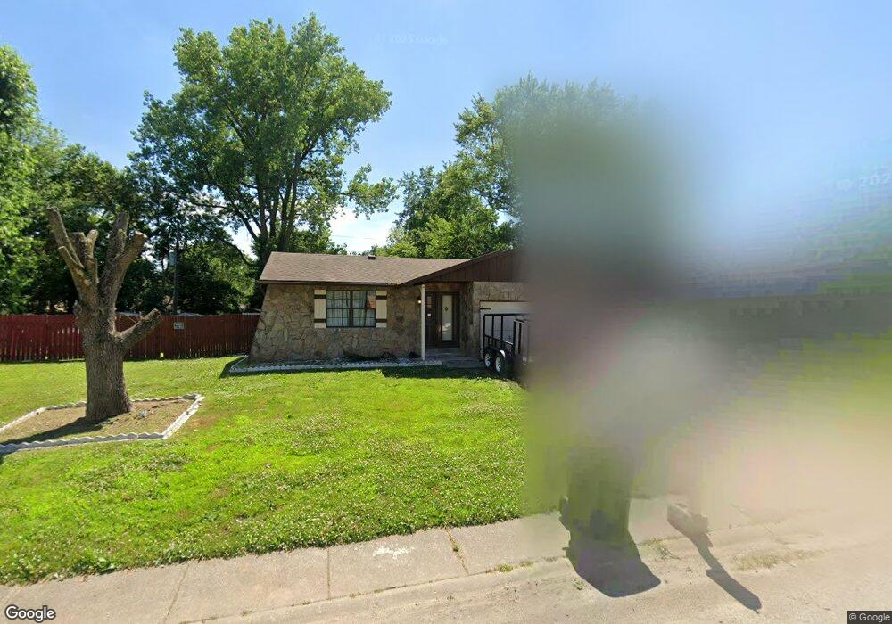
1994 Maple Tree Ln East Saint Louis, IL 62206
Estimated Value: $66,622 - $107,000
--
Bed
--
Bath
1,266
Sq Ft
$70/Sq Ft
Est. Value
About This Home
This home is located at 1994 Maple Tree Ln, East Saint Louis, IL 62206 and is currently estimated at $88,906, approximately $70 per square foot. 1994 Maple Tree Ln is a home located in St. Clair County.
Ownership History
Date
Name
Owned For
Owner Type
Purchase Details
Closed on
May 14, 2020
Sold by
Giger Kathleen M
Bought by
Hill Brandon S
Current Estimated Value
Purchase Details
Closed on
Dec 22, 2006
Sold by
Hankamer Gail
Bought by
Giger Kathleen M
Home Financials for this Owner
Home Financials are based on the most recent Mortgage that was taken out on this home.
Original Mortgage
$68,000
Interest Rate
6.24%
Mortgage Type
New Conventional
Purchase Details
Closed on
Feb 28, 2005
Sold by
Hankamer Walmer M
Bought by
Hankamer Walmer M and Hankamer Gail
Create a Home Valuation Report for This Property
The Home Valuation Report is an in-depth analysis detailing your home's value as well as a comparison with similar homes in the area
Home Values in the Area
Average Home Value in this Area
Purchase History
| Date | Buyer | Sale Price | Title Company |
|---|---|---|---|
| Hill Brandon S | $35,000 | None Available | |
| Giger Kathleen M | $85,000 | Benchmark Title Company | |
| Hankamer Walmer M | -- | -- |
Source: Public Records
Mortgage History
| Date | Status | Borrower | Loan Amount |
|---|---|---|---|
| Previous Owner | Giger Kathleen M | $68,000 |
Source: Public Records
Tax History Compared to Growth
Tax History
| Year | Tax Paid | Tax Assessment Tax Assessment Total Assessment is a certain percentage of the fair market value that is determined by local assessors to be the total taxable value of land and additions on the property. | Land | Improvement |
|---|---|---|---|---|
| 2024 | $1,941 | $16,202 | $1,406 | $14,796 |
| 2023 | $1,643 | $14,644 | $1,271 | $13,373 |
| 2022 | $1,356 | $12,834 | $1,114 | $11,720 |
| 2021 | $1,323 | $12,162 | $1,056 | $11,106 |
| 2020 | $37 | $11,163 | $1,106 | $10,057 |
| 2019 | $0 | $11,163 | $1,106 | $10,057 |
| 2018 | $0 | $11,326 | $1,122 | $10,204 |
| 2017 | $0 | $11,053 | $1,095 | $9,958 |
| 2016 | $301 | $11,621 | $1,091 | $10,530 |
| 2014 | -- | $11,494 | $1,079 | $10,415 |
| 2013 | $2,138 | $10,781 | $1,012 | $9,769 |
Source: Public Records
Map
Nearby Homes
- 1997 Oak Tree Ln
- 2013 Maple Tree Ln
- 2014 Florence St
- 2 Margie Dr
- 1713 Loretta Ave
- 2025 Sandy Ridge Rd
- 1128 Saint Benedict Dr
- 2016 Lynn St
- 2005 Louise Ave
- 1106 Saint Boniface Dr
- 2274 Carol St
- 1426 Richard Dr
- 1505 Camp Jackson Rd
- 34 Marilyn Ln
- 17 Hanover Ln
- 10 E Adams Dr
- 913 Joliet Dr Unit 1
- 30 Marilyn Ln
- 16 Helen Ct
- 22 Marilyn Ln
- 1992 Maple Tree Ln
- 1996 Maple Tree Ln
- 1913 Florence St
- 1990 Maple Tree Ln
- 1907 Florence St
- 1915 Florence St
- 1995 Maple Tree Ln
- 1993 Maple Tree Ln
- 2000 Maple Tree Ln
- 1997 Maple Tree Ln
- 1903 Florence St
- 1991 Maple Tree Ln
- 1919 Florence St
- 1999 Maple Tree Ln
- 1988 Maple Tree Ln
- 2002 Maple Tree Ln
- 1921 Florence St
- 1994 Oak Tree Ln
- 1992 Oak Tree Ln
- 2001 Maple Tree Ln