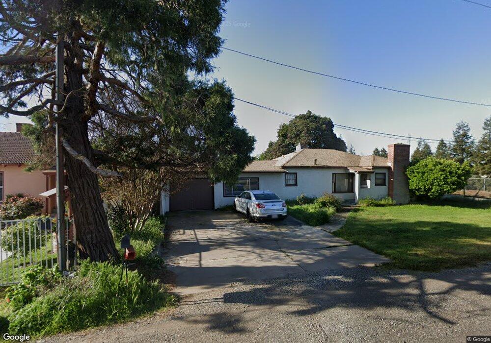
1994 W State Highway 140 Merced, CA 95341
Estimated Value: $258,000 - $351,000
2
Beds
1
Bath
1,371
Sq Ft
$225/Sq Ft
Est. Value
About This Home
This home is located at 1994 W State Highway 140, Merced, CA 95341 and is currently estimated at $308,009, approximately $224 per square foot. 1994 W State Highway 140 is a home located in Merced County with nearby schools including Leontine Gracey Elementary School, Tenaya Middle School, and El Capitan High School.
Ownership History
Date
Name
Owned For
Owner Type
Purchase Details
Closed on
Feb 23, 2026
Sold by
Michael Powell and Mccann Beverly A
Bought by
Grissom Clayton
Current Estimated Value
Home Financials for this Owner
Home Financials are based on the most recent Mortgage that was taken out on this home.
Original Mortgage
$8,890
Outstanding Balance
$8,615
Interest Rate
6.06%
Mortgage Type
FHA
Estimated Equity
$299,394
Purchase Details
Closed on
Jan 5, 2026
Sold by
Douthit Diana L
Bought by
Powell Michael and Mccann Beverley A
Home Financials for this Owner
Home Financials are based on the most recent Mortgage that was taken out on this home.
Original Mortgage
$8,890
Outstanding Balance
$8,615
Interest Rate
6.06%
Mortgage Type
FHA
Estimated Equity
$299,394
Purchase Details
Closed on
Jan 14, 2014
Sold by
Powell Michael
Bought by
Powell Michael and Douthit Diana L
Purchase Details
Closed on
Feb 10, 2009
Sold by
Powell Billy Ray and Powell Diane
Bought by
Powell Billy Ray
Purchase Details
Closed on
May 6, 2008
Sold by
Powell Billy Ray and Powell Diane
Bought by
Powell Billy Ray and Powell Diane
Purchase Details
Closed on
Jul 26, 2002
Sold by
Powell Billy Ray
Bought by
Powell Billy Ray and Powell Dianne
Purchase Details
Closed on
Apr 14, 1997
Sold by
Powell Billy R and Powell Edna M
Bought by
Powell Billy Ray and Powell Edna Mae
Create a Home Valuation Report for This Property
The Home Valuation Report is an in-depth analysis detailing your home's value as well as a comparison with similar homes in the area
Purchase History
We collect this data history from publicly available records. To have your information removed, we recommend requesting removal directly through your county’s website.
| Date | Buyer | Sale Price | Title Company |
|---|---|---|---|
| Grissom Clayton | $254,000 | First American Title | |
| Powell Michael | $60,000 | None Listed On Document | |
| Powell Michael | -- | None Available | |
| Powell Billy Ray | -- | None Available | |
| Powell Billy Ray | -- | None Available | |
| Powell Billy Ray | -- | -- | |
| Powell Billy Ray | -- | -- |
Source: Public Records
Mortgage History
We collect this data history from publicly available records. To have your information removed, we recommend requesting removal directly through your county’s website.
| Date | Status | Borrower | Loan Amount |
|---|---|---|---|
| Open | Grissom Clayton | $8,890 | |
| Open | Grissom Clayton | $249,399 |
Source: Public Records
Tax History
| Year | Tax Paid | Tax Assessment Tax Assessment Total Assessment is a certain percentage of the fair market value that is determined by local assessors to be the total taxable value of land and additions on the property. | Land | Improvement |
|---|---|---|---|---|
| 2025 | $1,085 | $102,135 | $25,593 | $76,542 |
| 2024 | $1,085 | $100,134 | $25,092 | $75,042 |
| 2023 | $1,071 | $98,171 | $24,600 | $73,571 |
| 2022 | $1,055 | $96,247 | $24,118 | $72,129 |
| 2021 | $1,053 | $94,361 | $23,646 | $70,715 |
| 2020 | $1,059 | $93,394 | $23,404 | $69,990 |
| 2019 | $1,042 | $91,564 | $22,946 | $68,618 |
| 2018 | $950 | $89,770 | $22,497 | $67,273 |
| 2017 | $986 | $88,010 | $22,056 | $65,954 |
| 2016 | $971 | $86,285 | $21,624 | $64,661 |
| 2015 | $955 | $84,990 | $21,300 | $63,690 |
| 2014 | $935 | $83,326 | $20,883 | $62,443 |
Source: Public Records
Map
Nearby Homes
- 2029 W State Highway 140
- 2044 W State Highway 140
- 980 Sydney Ln
- 1843 W 8th St
- 1847 W 8th St
- 1772 Heritage Dr
- 965 N Bryant
- 1803 Lopes Ave
- 2051 Wardrobe Ave
- 1664 W North Bear Creek Dr Unit 5
- 1670 W North Bear Creek Dr
- 1646 W North Bear Creek Dr
- 0 Thornton Rd
- 1648 W North Bear Creek Dr
- 1251 W 9th St
- 2500 N State Highway 59 Unit 36
- 2500 N State Highway 59
- 2500 N State Highway 59 Unit 278
- 2500 N State Highway 59 Unit 239
- 2500 N State Highway 59 Unit 18
- 2097 Patty Dr
- 0 Massasso St Unit 16010967
- 0 Massasso St Unit CRMC24188961
- 0 Massasso St Unit MC24188961
- 0 Massasso St Unit MC23075556
- 0 Massasso St Unit 222145394
- 0 Massasso St Unit 222145388
- 0 Massasso St Unit 222143296
- 2087 Patty Dr
- 2 Massasso St
- 1 Massasso St
- 2077 Patty Dr
- 1986 W State Highway 140
- 2096 Patty Dr
- 2086 Patty Dr
- 2057 Patty Dr
- 2078 W State Highway 140
- 2076 Patty Dr
- 1064 Massasso St
- 2037 Patty Dr
Your Personal Tour Guide
Ask me questions while you tour the home.