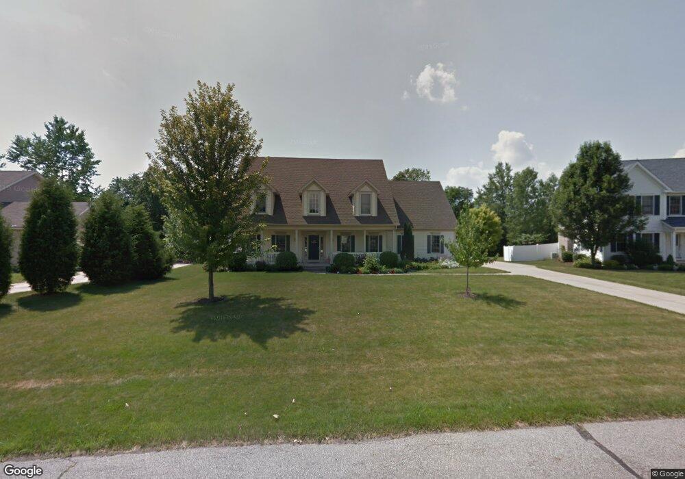
1995 Weston Dr Hudson, OH 44236
Estimated Value: $466,000 - $592,000
4
Beds
3
Baths
2,454
Sq Ft
$220/Sq Ft
Est. Value
About This Home
This home is located at 1995 Weston Dr, Hudson, OH 44236 and is currently estimated at $540,814, approximately $220 per square foot. 1995 Weston Dr is a home located in Summit County with nearby schools including Ellsworth Hill Elementary School, East Woods Intermediate School, and Hudson Middle School.
Ownership History
Date
Name
Owned For
Owner Type
Purchase Details
Closed on
Sep 15, 2005
Sold by
Lewis Mia E
Bought by
Lewis Mia E and The Mia E Lewis Revocable Trust
Current Estimated Value
Purchase Details
Closed on
May 24, 2004
Sold by
Nitzsche Larry and Nitzsche Julie
Bought by
Lewis Mia E
Home Financials for this Owner
Home Financials are based on the most recent Mortgage that was taken out on this home.
Original Mortgage
$252,000
Outstanding Balance
$121,550
Interest Rate
5.91%
Mortgage Type
Purchase Money Mortgage
Estimated Equity
$419,264
Purchase Details
Closed on
Jul 5, 2001
Sold by
Constock Homes Inc
Bought by
Nitzsche Larry and Nitzsche Julie
Home Financials for this Owner
Home Financials are based on the most recent Mortgage that was taken out on this home.
Original Mortgage
$160,000
Interest Rate
7.2%
Purchase Details
Closed on
Sep 8, 1995
Sold by
Broad Breck Dev Corp
Bought by
Chand Const Corp
Home Financials for this Owner
Home Financials are based on the most recent Mortgage that was taken out on this home.
Original Mortgage
$1,000,000
Interest Rate
7.76%
Mortgage Type
New Conventional
Create a Home Valuation Report for This Property
The Home Valuation Report is an in-depth analysis detailing your home's value as well as a comparison with similar homes in the area
Home Values in the Area
Average Home Value in this Area
Purchase History
| Date | Buyer | Sale Price | Title Company |
|---|---|---|---|
| Lewis Mia E | -- | -- | |
| Lewis Mia E | $315,000 | American Certified Title | |
| Nitzsche Larry | $289,900 | Midland Commerce Group | |
| Chand Const Corp | $1,250,000 | -- |
Source: Public Records
Mortgage History
| Date | Status | Borrower | Loan Amount |
|---|---|---|---|
| Open | Lewis Mia E | $252,000 | |
| Previous Owner | Nitzsche Larry | $160,000 | |
| Previous Owner | Chand Const Corp | $1,000,000 |
Source: Public Records
Tax History Compared to Growth
Tax History
| Year | Tax Paid | Tax Assessment Tax Assessment Total Assessment is a certain percentage of the fair market value that is determined by local assessors to be the total taxable value of land and additions on the property. | Land | Improvement |
|---|---|---|---|---|
| 2025 | $8,413 | $165,467 | $34,059 | $131,408 |
| 2024 | $8,413 | $165,467 | $34,059 | $131,408 |
| 2023 | $8,413 | $165,467 | $34,059 | $131,408 |
| 2022 | $6,437 | $112,767 | $23,170 | $89,597 |
| 2021 | $6,447 | $112,767 | $23,170 | $89,597 |
| 2020 | $6,334 | $112,770 | $23,170 | $89,600 |
| 2019 | $7,325 | $120,920 | $18,720 | $102,200 |
| 2018 | $7,299 | $120,920 | $18,720 | $102,200 |
| 2017 | $6,678 | $120,920 | $18,720 | $102,200 |
| 2016 | $6,726 | $107,480 | $18,720 | $88,760 |
| 2015 | $6,678 | $107,480 | $18,720 | $88,760 |
| 2014 | $6,697 | $107,480 | $18,720 | $88,760 |
| 2013 | $6,984 | $109,500 | $18,720 | $90,780 |
Source: Public Records
Map
Nearby Homes
- V/L Norton Rd
- 1884 Village Ct Unit X66
- 5139 Rockport Cove
- 1759 E Sapphire Dr
- 1620 Sapphire Dr
- 5465 Park Vista Ct
- 2327 Crockett Cir
- 1664 Cypress Ct
- 5473 Young Rd
- 4731 Haughton Ct
- 1529 Spruce Hill Dr
- 4891 Cedar Crest Ln
- 4877 Cedar Crest Ln
- 4901 Pebblehurst Dr
- 2380 Port Williams Dr Unit 2380
- 1627 Cypress Ct
- 5431 Diana Lynn Dr
- V/L Lawnmark Dr
- 2444 Port Charles Dr
- 0 Stow Rd Unit 5102979
- 1985 Weston Dr
- 2007 Weston Dr
- 2021 Norton Rd
- 1971 Weston Dr
- 1992 Weston Dr
- 1980 Weston Dr
- 4030 Longfellow Ln
- 2010 Weston Dr
- 1966 Weston Dr
- 2025 Norton Rd
- 4046 Longfellow Ln
- 4000 Deacon Ct
- 4012 Deacon Ct
- 4040 Deacon Ct
- 2088 Norton Rd
- 4024 Deacon Ct
- 2056 Norton Rd
- 3992 Deacon Ct
- 4060 Longfellow Ln
- 4041 Longfellow Ln