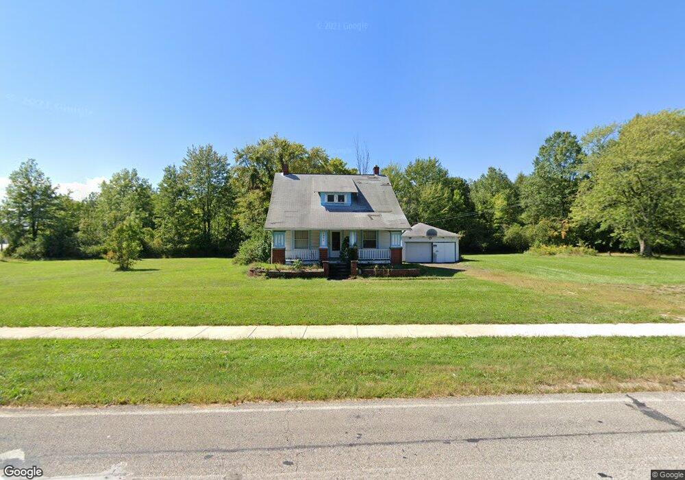
1996 Harris Rd Sheffield Village, OH 44054
Estimated Value: $196,022 - $257,000
4
Beds
2
Baths
1,598
Sq Ft
$137/Sq Ft
Est. Value
About This Home
This home is located at 1996 Harris Rd, Sheffield Village, OH 44054 and is currently estimated at $218,506, approximately $136 per square foot. 1996 Harris Rd is a home located in Lorain County with nearby schools including Knollwood Elementary School, Brookside Intermediate School, and Brookside Middle School.
Ownership History
Date
Name
Owned For
Owner Type
Purchase Details
Closed on
Apr 18, 2017
Sold by
Pilan Christopher P
Bought by
Park Place Equity Llc
Current Estimated Value
Purchase Details
Closed on
Jul 21, 2014
Sold by
Us Bank Na
Bought by
Pilan Christopher P
Purchase Details
Closed on
Jun 24, 2014
Sold by
Vasiliadis Jim
Bought by
Us Bank Na
Purchase Details
Closed on
Feb 6, 1998
Sold by
Vasiliadis Panaglodis H and Vasiliadis Angella
Bought by
Vasiliadis Jim
Create a Home Valuation Report for This Property
The Home Valuation Report is an in-depth analysis detailing your home's value as well as a comparison with similar homes in the area
Home Values in the Area
Average Home Value in this Area
Purchase History
| Date | Buyer | Sale Price | Title Company |
|---|---|---|---|
| Park Place Equity Llc | -- | -- | |
| Pilan Christopher P | $70,400 | Omega Title Agency Llc | |
| Us Bank Na | $44,000 | None Available | |
| Vasiliadis Jim | -- | Lorain County Title Co Inc |
Source: Public Records
Tax History Compared to Growth
Tax History
| Year | Tax Paid | Tax Assessment Tax Assessment Total Assessment is a certain percentage of the fair market value that is determined by local assessors to be the total taxable value of land and additions on the property. | Land | Improvement |
|---|---|---|---|---|
| 2024 | $2,246 | $45,080 | $12,691 | $32,389 |
| 2023 | $2,393 | $42,809 | $12,117 | $30,692 |
| 2022 | $2,368 | $42,809 | $12,117 | $30,692 |
| 2021 | $2,383 | $42,809 | $12,117 | $30,692 |
| 2020 | $2,258 | $37,350 | $10,570 | $26,780 |
| 2019 | $2,244 | $37,350 | $10,570 | $26,780 |
| 2018 | $2,259 | $37,350 | $10,570 | $26,780 |
| 2017 | $2,264 | $34,220 | $10,000 | $24,220 |
| 2016 | $2,288 | $34,220 | $10,000 | $24,220 |
| 2015 | $2,282 | $34,220 | $10,000 | $24,220 |
| 2014 | $2,060 | $34,220 | $10,000 | $24,220 |
| 2013 | $2,038 | $34,030 | $9,810 | $24,220 |
Source: Public Records
Map
Nearby Homes
- 4757 Colorado Ave
- 4286 Holl Ave
- 4283 Holl Ave
- VL Maplewood Ave
- 4272 Brockley Ave
- 4260 Brockley Ave
- 3006 Abbe Rd N
- 4154 Belle Ave
- 762 Maplewood Ave
- 738 W Shore Blvd
- 689 Lafayette Blvd
- 931 East Dr
- 737 Dunny Ave
- 4885 Ivanhoe Ave
- 699 Irving Park Blvd
- 0 Kenilworth Ave
- 967 Warwick Dr
- 662 Kenilworth Ave
- 644 Pasadena Ave
- 630 Treadway Blvd
- 0 State Route 611 Unit 3272726
- 4734 Colorado Ave
- 4638 Colorado Ave
- 4751 Colorado Ave
- 2085 Orchard Ct
- 2115 Orchard Ct
- 2075 Orchard Ct
- 2129 Orchard Ct
- 4755 Colorado Ave
- 2153 Orchard Ct
- 2175 Orchard Ct
- 4818 Colorado Ave
- 4818 Colorado Ave
- 4759 Colorado Ave
- 2130 Orchard Ct
- 2070 Orchard Ct
- 4619 Colorado Ave
- 2160 Orchard Ct
- 0 Colorado Ave
- 4018 Colorado Ave