Estimated Value: $865,740 - $1,165,000
Studio
3
Baths
2,695
Sq Ft
$375/Sq Ft
Est. Value
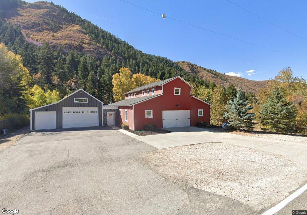
About This Home
This home is located at 1998 E Highway 150, Kamas, UT 84036 and is currently estimated at $1,010,185, approximately $374 per square foot. 1998 E Highway 150 is a home located in Summit County with nearby schools including South Summit Elementary School and South Summit High School.
Ownership History
Date
Name
Owned For
Owner Type
Purchase Details
Closed on
Oct 3, 2023
Sold by
Boyd Aaron
Bought by
Boyd Family Trust and Boyd
Current Estimated Value
Purchase Details
Closed on
May 4, 2023
Sold by
Boyd Aaron Joseph
Bought by
Boyd Family Trust
Purchase Details
Closed on
Aug 11, 2010
Sold by
Weinstein Steve
Bought by
Boyd Aaron
Purchase Details
Closed on
Oct 16, 2006
Sold by
Weinstein Steven and Monsen Amanda
Bought by
Weinstein Steve
Purchase Details
Closed on
Apr 27, 2006
Sold by
Brighton S Richard and S Richard Brighton Family Livi
Bought by
Weinstein Steve and Monsen Amanda
Create a Home Valuation Report for This Property
The Home Valuation Report is an in-depth analysis detailing your home's value as well as a comparison with similar homes in the area
Home Values in the Area
Average Home Value in this Area
Purchase History
| Date | Buyer | Sale Price | Title Company |
|---|---|---|---|
| Boyd Family Trust | -- | Atlas Title Company | |
| Boyd Family Trust | -- | None Listed On Document | |
| Boyd Aaron | -- | -- | |
| Weinstein Steve | -- | First American Title | |
| Weinstein Steve | -- | None Available |
Source: Public Records
Mortgage History
| Date | Status | Borrower | Loan Amount |
|---|---|---|---|
| Closed | Boyd Aaron | $0 |
Source: Public Records
Tax History
| Year | Tax Paid | Tax Assessment Tax Assessment Total Assessment is a certain percentage of the fair market value that is determined by local assessors to be the total taxable value of land and additions on the property. | Land | Improvement |
|---|---|---|---|---|
| 2025 | $4,102 | $763,966 | $92,500 | $671,466 |
| 2024 | $3,836 | $760,466 | $89,000 | $671,466 |
| 2023 | $3,836 | $734,830 | $75,000 | $659,830 |
| 2022 | $3,802 | $636,345 | $59,000 | $577,345 |
| 2021 | $3,049 | $413,724 | $39,100 | $374,624 |
| 2020 | $2,868 | $363,043 | $39,100 | $323,943 |
| 2019 | $3,173 | $363,043 | $39,100 | $323,943 |
| 2018 | $2,549 | $305,172 | $39,100 | $266,072 |
| 2017 | $2,324 | $292,502 | $39,100 | $253,402 |
| 2016 | $2,206 | $260,827 | $39,100 | $221,727 |
| 2015 | $2,254 | $260,827 | $0 | $0 |
| 2013 | $1,340 | $143,455 | $0 | $0 |
Source: Public Records
Map
Nearby Homes
- 2189 Samak Park Loop Unit 43
- 960 Wide Hollow Rd Unit 9
- 1264 Country Ln Unit 72
- 872 High Country Dr Unit 20
- 1040 High Country Ln
- 1040 High Country Ln Unit 76
- 846 E 270 S
- 430 E 600 S
- 798 Lazy Way Unit 11
- 798 Lazy Way
- 3589 Beaver Creek Rd
- 1537 Stewart Lane Lot: 4
- 1538 Stewart Lane Lot: 3
- 354 E 370 S
- 352 E 340 S
- 3716 Chokecherry Ln Unit 343
- 3805 Beaver Creek Rd
- 1539 Rocky Mountain Way
- 1539 Rocky Mountain Way Unit 401
- 1465 Rocky Mountain Way Unit 204
- 1998 E Mirror Lake Hwy
- 1986 E Mirrow Lake Hgy
- 1986 E Mirror Lake Hwy
- 2010 E Highway 150
- 1986 E Highway 150
- 1986 E Mirror Lake Hwy
- 2010 E Mirror Lake Hwy
- 2005 Samak Park Loop
- 2015 E Highway 150
- 2051 Samak Park Loop
- 2032 Samak Park Loop
- 2032 Samak Park Loop Unit 21-22
- 2021 E Highway 150
- 2021 E Mirror Lake Hwy
- 1985 E Highway 150
- 2056 N Samak Park Loop E
- 2056 N Samak Park Loop E Unit 23
- 2056 Samak Park
- 43 Samak Park Loop
- 52 Samak Park Loop
Your Personal Tour Guide
Ask me questions while you tour the home.