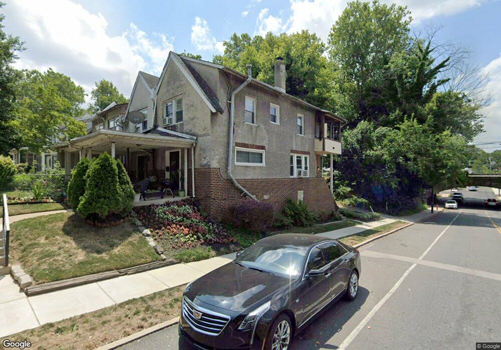
1998 Upland Way Philadelphia, PA 19131
Wynnefield NeighborhoodEstimated Value: $206,000 - $265,000
3
Beds
1
Bath
1,280
Sq Ft
$182/Sq Ft
Est. Value
About This Home
This home is located at 1998 Upland Way, Philadelphia, PA 19131 and is currently estimated at $233,283, approximately $182 per square foot. 1998 Upland Way is a home located in Philadelphia County with nearby schools including Samuel Gompers School, Overbrook High School, and Ad Prima Charter School.
Ownership History
Date
Name
Owned For
Owner Type
Purchase Details
Closed on
Mar 1, 2002
Sold by
Brown Barbara Ruth
Bought by
Merkerson Lanette
Current Estimated Value
Home Financials for this Owner
Home Financials are based on the most recent Mortgage that was taken out on this home.
Original Mortgage
$66,800
Outstanding Balance
$27,298
Interest Rate
7.04%
Estimated Equity
$205,985
Create a Home Valuation Report for This Property
The Home Valuation Report is an in-depth analysis detailing your home's value as well as a comparison with similar homes in the area
Home Values in the Area
Average Home Value in this Area
Purchase History
| Date | Buyer | Sale Price | Title Company |
|---|---|---|---|
| Merkerson Lanette | $68,900 | -- |
Source: Public Records
Mortgage History
| Date | Status | Borrower | Loan Amount |
|---|---|---|---|
| Open | Merkerson Lanette | $66,800 |
Source: Public Records
Tax History Compared to Growth
Tax History
| Year | Tax Paid | Tax Assessment Tax Assessment Total Assessment is a certain percentage of the fair market value that is determined by local assessors to be the total taxable value of land and additions on the property. | Land | Improvement |
|---|---|---|---|---|
| 2026 | $1,193 | $243,900 | $48,780 | $195,120 |
| 2025 | $1,193 | $243,900 | $48,780 | $195,120 |
| 2024 | $1,193 | $243,900 | $48,780 | $195,120 |
| 2023 | $1,193 | $221,600 | $44,320 | $177,280 |
| 2022 | $1,193 | $85,200 | $44,320 | $40,880 |
| 2021 | $1,193 | $0 | $0 | $0 |
| 2020 | $1,193 | $0 | $0 | $0 |
| 2019 | $1,193 | $0 | $0 | $0 |
| 2018 | $1,193 | $0 | $0 | $0 |
| 2017 | $1,193 | $0 | $0 | $0 |
| 2016 | $1,193 | $0 | $0 | $0 |
| 2015 | $1,142 | $0 | $0 | $0 |
| 2014 | -- | $155,400 | $14,994 | $140,406 |
| 2012 | -- | $9,088 | $1,745 | $7,343 |
Source: Public Records
Map
Nearby Homes
- 5920 Woodbine Ave
- 5933 Woodcrest Ave
- 5939 Drexel Rd
- 2217 N 59th St
- 6127 Lebanon Ave
- 2211 Melvin St
- 5845 Woodcrest Ave
- 5665 Lebanon Ave
- 5667 Lebanon Ave
- 1122 26 N 63rd St
- 6158 Lebanon Ave
- 6021 Clifford Terrace
- 6146 W Columbia Ave
- 5708 Malvern Ave
- 2112 N 57th St
- 5717 Woodcrest Ave
- 1258 N 64th St
- 6136 W Oxford St
- 6380 City Ave
- 5669 W Berks St
- 1996 Upland Way
- 1992 Upland Way
- 1990 Upland Way
- 1988 Upland Way
- 1986 Upland Way
- 1984 Upland Way
- 6003 Woodbine Ave
- 6001 Woodbine Ave
- 6005 Woodbine Ave
- 5998 Woodbine Ave
- 6007 Woodbine Ave
- 5996 Woodbine Ave
- 2010 Upland Way
- 2001 Upland Way
- 5992 Woodbine Ave
- 2014 Upland Way
- 1981 Upland Way Unit 104
- 1981 Upland Way
- 2007 Upland Way
- 5990 Woodbine Ave