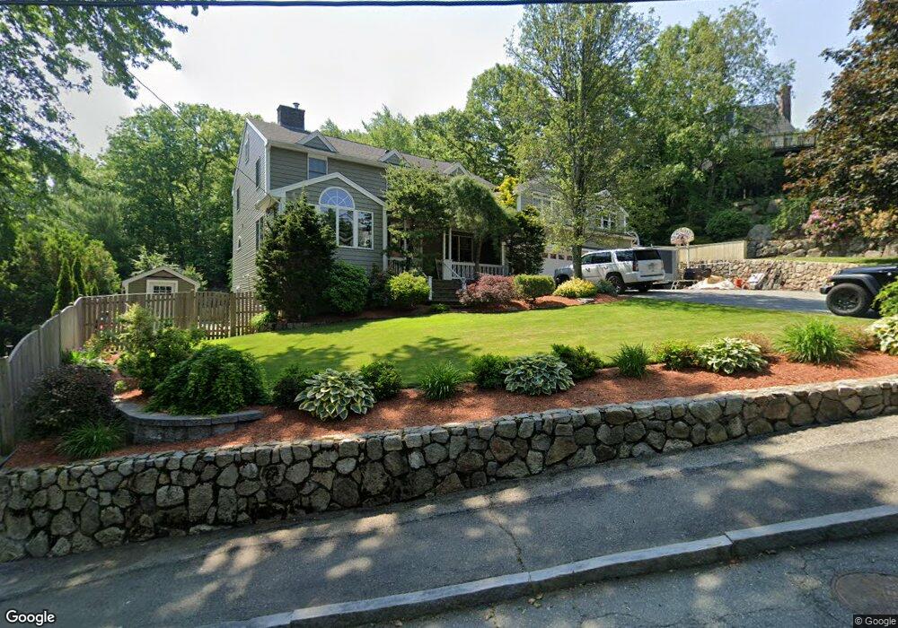
2 Amanda Way Peabody, MA 01960
South Peabody NeighborhoodEstimated Value: $892,000 - $1,293,000
5
Beds
5
Baths
2,868
Sq Ft
$357/Sq Ft
Est. Value
About This Home
This home is located at 2 Amanda Way, Peabody, MA 01960 and is currently estimated at $1,024,426, approximately $357 per square foot. 2 Amanda Way is a home located in Essex County with nearby schools including Peabody Veterans Memorial High School, North Shore Christian School, and St John The Baptist School.
Ownership History
Date
Name
Owned For
Owner Type
Purchase Details
Closed on
May 5, 2017
Sold by
2 Amanda Way Rt
Bought by
Palm Denielle and Palm Gary
Current Estimated Value
Purchase Details
Closed on
Apr 14, 2017
Sold by
2 Amanda Way Rt
Bought by
Palm Denielle and Palm Gary
Purchase Details
Closed on
Mar 10, 2014
Sold by
Palm Denielle and Palm Gary
Bought by
2 Amanda Way Rt and Clickstein Howard D
Purchase Details
Closed on
Oct 22, 2013
Sold by
Clickstein Howard D and Clickstein Robin A
Bought by
Palm Denielle and Palm Gary
Home Financials for this Owner
Home Financials are based on the most recent Mortgage that was taken out on this home.
Original Mortgage
$88,000
Interest Rate
4.14%
Purchase Details
Closed on
May 16, 2013
Sold by
2 Amanda Way Rt and Clickstein Howard D
Bought by
Clickstein Howard D and Clickstein Robin A
Purchase Details
Closed on
Dec 17, 2010
Sold by
Clickstein Howard D and Clickstein Robin
Bought by
2 Amanda Way Rt and Clickstein Howard D
Purchase Details
Closed on
Nov 19, 2010
Sold by
2 Amanda Way Rt and Clickstein Howard D
Bought by
Clickstein Howard D and Clickstein Robin
Purchase Details
Closed on
Jan 31, 2005
Sold by
2 Amanda Way Rt and Clickstein Howard D
Bought by
Clickstein Howard D
Purchase Details
Closed on
Nov 29, 2004
Sold by
2 Amanda Way Rt
Bought by
Clickstein Howard
Purchase Details
Closed on
Aug 12, 2003
Sold by
Clickstein Howard D and Clickstein Robin
Bought by
2 Amanda Way Rt
Create a Home Valuation Report for This Property
The Home Valuation Report is an in-depth analysis detailing your home's value as well as a comparison with similar homes in the area
Home Values in the Area
Average Home Value in this Area
Purchase History
| Date | Buyer | Sale Price | Title Company |
|---|---|---|---|
| Palm Denielle | -- | -- | |
| Palm Denielle | -- | -- | |
| 2 Amanda Way Rt | -- | -- | |
| Palm Denielle | -- | -- | |
| Clickstein Howard D | -- | -- | |
| 2 Amanda Way Rt | -- | -- | |
| Clickstein Howard D | -- | -- | |
| Clickstein Howard D | -- | -- | |
| Clickstein Howard | -- | -- | |
| 2 Amanda Way Rt | -- | -- | |
| Clickstein Howard D | -- | -- |
Source: Public Records
Mortgage History
| Date | Status | Borrower | Loan Amount |
|---|---|---|---|
| Previous Owner | Clickstein Howard D | $88,000 |
Source: Public Records
Tax History Compared to Growth
Tax History
| Year | Tax Paid | Tax Assessment Tax Assessment Total Assessment is a certain percentage of the fair market value that is determined by local assessors to be the total taxable value of land and additions on the property. | Land | Improvement |
|---|---|---|---|---|
| 2025 | $8,513 | $919,300 | $292,900 | $626,400 |
| 2024 | $7,699 | $844,200 | $292,900 | $551,300 |
| 2023 | $7,338 | $770,800 | $244,100 | $526,700 |
| 2022 | $6,588 | $652,300 | $212,300 | $440,000 |
| 2021 | $6,439 | $613,800 | $193,000 | $420,800 |
| 2020 | $6,521 | $607,200 | $193,000 | $414,200 |
| 2019 | $6,276 | $570,000 | $193,000 | $377,000 |
| 2018 | $6,322 | $551,700 | $172,300 | $379,400 |
| 2017 | $5,820 | $494,900 | $172,300 | $322,600 |
| 2016 | $5,866 | $492,100 | $172,300 | $319,800 |
| 2015 | $6,039 | $491,000 | $172,300 | $318,700 |
Source: Public Records
Map
Nearby Homes
- 41 Dexter St
- 6 Christopher Terrace
- 5 Quarry Terrace
- 5 Louis Rd
- 30 Saint Ann's Ave
- 3 Veterans Memorial Dr
- 17 Janet Ln
- 29 Rockway Rd
- 60 Lynn St
- 232 Lynn St
- 34 Glendale Ave
- 35 Oak Ridge Cir
- 69 Saunders Rd
- 85 Range Ave
- 325 Den Quarry Rd
- 39 Graves Rd
- 217 Cedar Brook Rd
- 18 Woodrow Terrace
- 16 Sarah's Way
- 68 Sutcliffe Rd