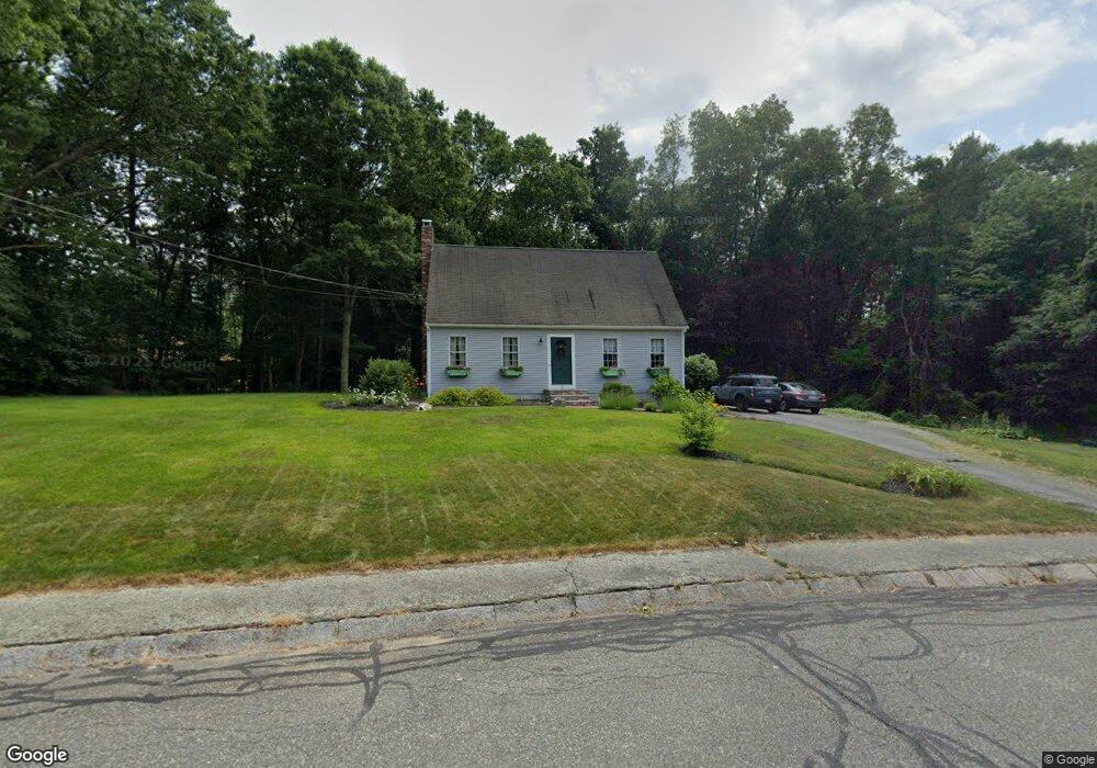
2 Brookside Dr Bridgewater, MA 02324
Estimated Value: $634,441 - $729,000
3
Beds
3
Baths
1,638
Sq Ft
$415/Sq Ft
Est. Value
About This Home
This home is located at 2 Brookside Dr, Bridgewater, MA 02324 and is currently estimated at $679,610, approximately $414 per square foot. 2 Brookside Dr is a home located in Plymouth County with nearby schools including Mitchell Elementary School, Williams Intermediate School, and Bridgewater Middle School.
Ownership History
Date
Name
Owned For
Owner Type
Purchase Details
Closed on
May 17, 2000
Sold by
Cahill Cheryl A
Bought by
Pitts Fordie H and Pitts Shari A
Current Estimated Value
Home Financials for this Owner
Home Financials are based on the most recent Mortgage that was taken out on this home.
Original Mortgage
$182,800
Interest Rate
8.19%
Mortgage Type
Purchase Money Mortgage
Purchase Details
Closed on
May 2, 1994
Sold by
Ebsary William J
Bought by
Cahill Michale J and Cahill Cheryl A
Home Financials for this Owner
Home Financials are based on the most recent Mortgage that was taken out on this home.
Original Mortgage
$136,000
Interest Rate
7.7%
Mortgage Type
Purchase Money Mortgage
Create a Home Valuation Report for This Property
The Home Valuation Report is an in-depth analysis detailing your home's value as well as a comparison with similar homes in the area
Home Values in the Area
Average Home Value in this Area
Purchase History
| Date | Buyer | Sale Price | Title Company |
|---|---|---|---|
| Pitts Fordie H | $228,500 | -- | |
| Cahill Michale J | $170,000 | -- |
Source: Public Records
Mortgage History
| Date | Status | Borrower | Loan Amount |
|---|---|---|---|
| Open | Cahill Michale J | $242,000 | |
| Closed | Cahill Michale J | $182,800 | |
| Closed | Cahill Michale J | $182,800 | |
| Previous Owner | Cahill Michale J | $136,000 |
Source: Public Records
Tax History
| Year | Tax Paid | Tax Assessment Tax Assessment Total Assessment is a certain percentage of the fair market value that is determined by local assessors to be the total taxable value of land and additions on the property. | Land | Improvement |
|---|---|---|---|---|
| 2025 | $6,691 | $565,600 | $239,000 | $326,600 |
| 2024 | $6,507 | $536,000 | $227,600 | $308,400 |
| 2023 | $6,437 | $501,300 | $212,600 | $288,700 |
| 2022 | $6,352 | $443,600 | $186,600 | $257,000 |
| 2021 | $5,740 | $396,400 | $166,600 | $229,800 |
| 2020 | $5,578 | $378,700 | $160,100 | $218,600 |
| 2019 | $5,505 | $371,200 | $160,100 | $211,100 |
| 2018 | $5,408 | $356,000 | $162,000 | $194,000 |
| 2017 | $5,273 | $337,800 | $162,000 | $175,800 |
| 2016 | $5,057 | $325,400 | $158,800 | $166,600 |
| 2015 | $5,091 | $313,500 | $154,100 | $159,400 |
| 2014 | $5,075 | $312,300 | $155,500 | $156,800 |
Source: Public Records
Map
Nearby Homes
- 35 Stockbridge Rd
- 65 Harvest Ln
- 557 Forest St
- 1 Jennifer Cir
- 256 Cross St
- 260 Boxwood Ln
- 345 Cross St
- 1 Anacki Ln Unit 24
- 110 Cobblestone Ln
- 8 North St
- 51 Cottage St
- 28 Beninati Farm Rd
- 220 Bedford St Unit 32
- 1359 Old Pleasant St
- 302 Pleasant St
- 40 Country Club Dr
- 118 Plesant St
- 120 Worcester St
- 35 Nelson Dr
- 35 Leonard St Unit 3
- 125 Deerfield Dr
- 10 Wynnwood Cir
- 20 Wynnwood Cir
- 1 Brookside Dr
- 135 Deerfield Dr
- 115 Deerfield Dr
- 3 Brookside Dr
- 55 Woodland Dr
- 45 Woodland Dr
- 30 Wynnwood Cir
- 140 Deerfield Dr
- 15 Wynnwood Cir
- 105 Deerfield Dr
- 25 Wynnwood Cir
- 5 Stockbridge Rd
- 120 Deerfield Dr
- 145 Deerfield Dr
- 35 Woodland Dr
- 110 Deerfield Dr
- 60 Woodland Dr
Your Personal Tour Guide
Ask me questions while you tour the home.