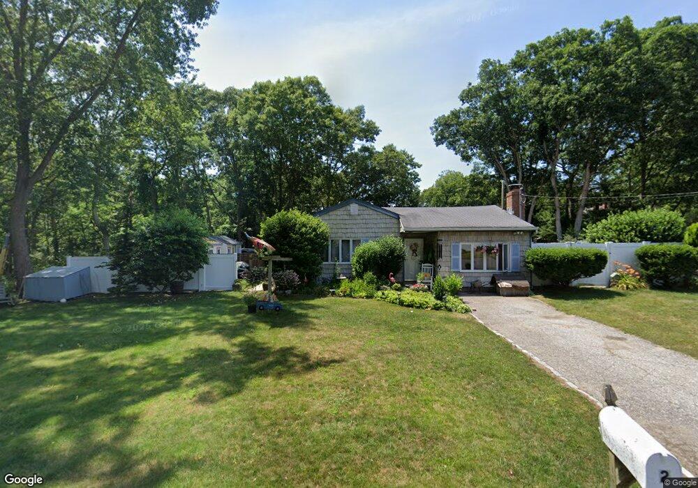
2 Burney Blvd Mastic, NY 11950
Estimated Value: $510,000 - $574,000
3
Beds
1
Bath
1,476
Sq Ft
$372/Sq Ft
Est. Value
About This Home
This home is located at 2 Burney Blvd, Mastic, NY 11950 and is currently estimated at $548,506, approximately $371 per square foot. 2 Burney Blvd is a home located in Suffolk County with nearby schools including Eastport-South Manor Junior/Senior High School.
Ownership History
Date
Name
Owned For
Owner Type
Purchase Details
Closed on
May 26, 2000
Sold by
Federal Home Loan Mortgage Corporation
Bought by
Beckendorf Laura A
Current Estimated Value
Home Financials for this Owner
Home Financials are based on the most recent Mortgage that was taken out on this home.
Original Mortgage
$85,700
Outstanding Balance
$29,997
Interest Rate
8.12%
Mortgage Type
FHA
Estimated Equity
$518,509
Purchase Details
Closed on
Jan 7, 2000
Sold by
Bank United Of Texas Fsb
Bought by
Federal Home Loan Mortgage Corporation
Purchase Details
Closed on
Jun 1, 1999
Sold by
Rivera Miguel A and Rivera Michelle D
Bought by
Bank United Of Texas Fsb
Purchase Details
Closed on
Oct 26, 1995
Sold by
Federal Home Loan Mortgage Corporation
Bought by
Rivera Miguel A and Rivera Michelle D
Create a Home Valuation Report for This Property
The Home Valuation Report is an in-depth analysis detailing your home's value as well as a comparison with similar homes in the area
Home Values in the Area
Average Home Value in this Area
Purchase History
| Date | Buyer | Sale Price | Title Company |
|---|---|---|---|
| Beckendorf Laura A | $78,000 | Commonwealth Land Title Ins | |
| Federal Home Loan Mortgage Corporation | -- | Commonwealth Land Title Ins | |
| Bank United Of Texas Fsb | $96,500 | Advantage Title | |
| Rivera Miguel A | $86,000 | -- |
Source: Public Records
Mortgage History
| Date | Status | Borrower | Loan Amount |
|---|---|---|---|
| Open | Beckendorf Laura A | $85,700 |
Source: Public Records
Tax History
| Year | Tax Paid | Tax Assessment Tax Assessment Total Assessment is a certain percentage of the fair market value that is determined by local assessors to be the total taxable value of land and additions on the property. | Land | Improvement |
|---|---|---|---|---|
| 2024 | $8,642 | $2,210 | $200 | $2,010 |
| 2023 | $8,642 | $2,210 | $200 | $2,010 |
| 2022 | $7,486 | $2,210 | $200 | $2,010 |
| 2021 | $7,486 | $2,210 | $200 | $2,010 |
| 2020 | $7,817 | $2,210 | $200 | $2,010 |
| 2019 | $7,817 | $0 | $0 | $0 |
| 2018 | $7,374 | $2,210 | $200 | $2,010 |
| 2017 | $7,374 | $2,210 | $200 | $2,010 |
| 2016 | $7,295 | $2,210 | $200 | $2,010 |
| 2015 | -- | $2,210 | $200 | $2,010 |
| 2014 | -- | $2,210 | $200 | $2,010 |
Source: Public Records
Map
Nearby Homes
- 58 Pentmoor Dr
- 25 Sweetbriar Dr
- 9 Dreamland St
- 45 Floradora Dr
- 117 Fulton Ave
- 12 Applegate Dr
- New Construction Dover Place
- 86 Stuyvesant Ave
- 129 Keller Dr
- 2 Fenwick St
- 125 Dana Ave
- 79 Stuyvesant Ave
- 71 Stuyvesant Ave
- 64 Vernon Ave
- 17 Nelson Place
- VL Lambert Ave
- 77 Washington Ave
- NC Malta Place
- VL Ave
- VL Moriches-Middle Island Rd
Your Personal Tour Guide
Ask me questions while you tour the home.