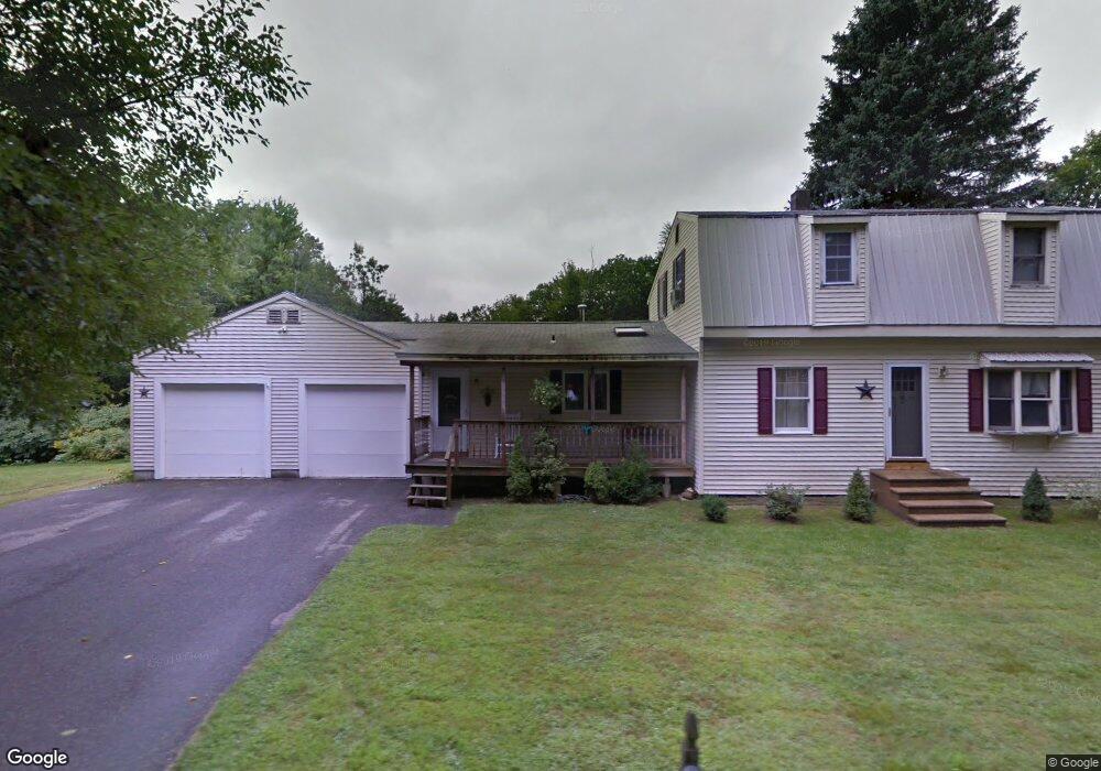
2 Campbell St Rutland, MA 01543
Estimated Value: $197,000 - $528,000
3
Beds
2
Baths
1,770
Sq Ft
$233/Sq Ft
Est. Value
About This Home
This home is located at 2 Campbell St, Rutland, MA 01543 and is currently estimated at $411,907, approximately $232 per square foot. 2 Campbell St is a home located in Worcester County with nearby schools including Wachusett Regional High School.
Ownership History
Date
Name
Owned For
Owner Type
Purchase Details
Closed on
Dec 28, 2023
Sold by
Guillotte Lisa M
Bought by
Guillotte Pamela J and Guillotte Robert D
Current Estimated Value
Purchase Details
Closed on
May 4, 2016
Sold by
Guillotte Rrobert D and Guillotte Pamela J
Bought by
Guillotte Robert D and Guillotte Pamela J
Purchase Details
Closed on
Aug 13, 2008
Sold by
Guillotte Pamela Jean and Guillotte Robert D
Bought by
Guillotte Lisa M and Guillotte Pamela Jean
Create a Home Valuation Report for This Property
The Home Valuation Report is an in-depth analysis detailing your home's value as well as a comparison with similar homes in the area
Home Values in the Area
Average Home Value in this Area
Purchase History
| Date | Buyer | Sale Price | Title Company |
|---|---|---|---|
| Guillotte Pamela J | -- | None Available | |
| Guillotte Robert D | -- | -- | |
| Guillotte Lisa M | -- | -- |
Source: Public Records
Tax History Compared to Growth
Tax History
| Year | Tax Paid | Tax Assessment Tax Assessment Total Assessment is a certain percentage of the fair market value that is determined by local assessors to be the total taxable value of land and additions on the property. | Land | Improvement |
|---|---|---|---|---|
| 2025 | $4,773 | $335,200 | $97,600 | $237,600 |
| 2024 | $4,652 | $313,700 | $93,700 | $220,000 |
| 2023 | $4,261 | $310,600 | $88,400 | $222,200 |
| 2022 | $3,995 | $253,000 | $74,700 | $178,300 |
| 2021 | $3,858 | $231,000 | $74,700 | $156,300 |
| 2020 | $3,587 | $203,700 | $70,900 | $132,800 |
| 2019 | $3,557 | $198,800 | $67,500 | $131,300 |
| 2018 | $3,443 | $189,900 | $67,500 | $122,400 |
| 2017 | $3,479 | $189,900 | $67,500 | $122,400 |
| 2016 | $3,306 | $190,300 | $64,200 | $126,100 |
| 2015 | $3,274 | $185,500 | $64,200 | $121,300 |
| 2014 | $3,174 | $185,500 | $64,200 | $121,300 |
Source: Public Records
Map
Nearby Homes
- 2 Simon Davis Dr
- 35 Brintnal Dr
- 73 Brintnal Dr
- 81 Glenwood Place
- 101 Brintnal Dr
- 175 Glenwood Rd
- 271 Glenwood Rd
- 40 Brunelle Dr
- 16 Richards Ave
- 147 E County Rd Unit 149
- 139 E County Rd Unit 139
- 55 Pommogussett Rd
- 45 Old Colony Rd
- 25 Watson Ln
- 56 Hubbardston Rd
- 5 Miles Rd
- 32 Pommogussett Rd Unit 1
- 51 Woodside Ave
- 47 Woodside Ave
- 10 Soucy Dr
- 4 Campbell St
- 4 Campbell St
- 8 Campbell St
- 8B Campbell St
- 3 Campbell St
- 5 Campbell St
- 352 Pommogussett Rd
- 11 Campbell St
- 9 Campbell St
- 10 Campbell St
- 351 Pommogussett Rd
- 6 Bushy Ln
- 12 Campbell St
- 338 Pommogussett Rd
- 15 Campbell St
- 18 Campbell St
- 330 Pommogussett Rd
- 339 Pommogussett Rd
- 427 E County Rd
- 18 Crestview Dr