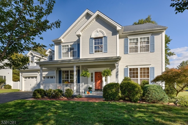
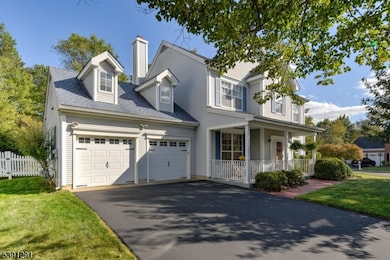
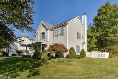
2 Carlisle Rd Branchburg, NJ 08876
Branchburg Township NeighborhoodEstimated payment $4,819/month
Highlights
- Popular Property
- Colonial Architecture
- Wood Flooring
- Stony Brook School Rated A-
- Vaulted Ceiling
- Corner Lot
About This Home
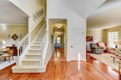
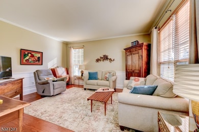
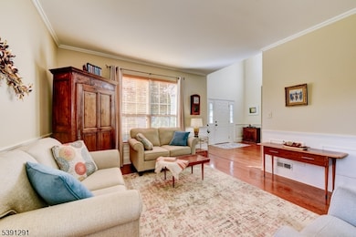
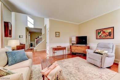
This immaculate, renovated & sunny colonial sits on a prime corner lot in sought-out Mountainview Farms. Home features renovated Kitchen & Bathrooms, Wood floors, New garage doors, Driveway (2021), Underground Sprinklers, newer HVAC (approx9 yrs), roof (approx 13 yrs) &more. On approach, the home exudes charm w/manicured landscaping& rocking chair porch. Inside you are welcomed w/a sun-filled 2-floor foyer flanked by an ample Living Rm & stylish Dining Rm-both w/w/wainscotting & wood Flrs. Inviting you to the rear of the home is a wall of windows, letting in natural light throughout the Kitchen & Family Rm. Beautifully renovated Kitchen features granite countertops,stylish backsplash & SS appliances. Kitchen flows seamlessly into Family Rm w/ a cozy fireplace. An updated Powder Rm & Laundry Rm w/new Washer (2025) complete the 1st Floor. Upstairs boasts a spacious Primary Bedroom Suite w/vaulted ceilings, walk-in closet& a luxurious renovated Bathrm w/a double granite vanity,shower& large soaking tub. You also find a renovated Hall Bathroom & 3 additional Bedrooms w/Bamboo flooring- charming throughout. A wonderful ample backyard w/brick patio,2 retractable awnings& maintenance-free fence. Nestled in an idyllic neighborhood w/close proximity to White Oak Park w/walking trails, tennis/pickleball courts, playgrounds & community events. Ideal combination of thoughtful updates,fantastic location & timeless charm! BEST & FINAL OFFERS BY MON 10/27 3pm.
Listing Agent
LISA BERCHOFF
WEICHERT REALTORS Brokerage Phone: 908-334-9399 Listed on: 10/15/2025
Home Details
Home Type
- Single Family
Est. Annual Taxes
- $9,950
Year Built
- Built in 1992 | Remodeled
Lot Details
- 0.28 Acre Lot
- Corner Lot
- Level Lot
- Sprinkler System
HOA Fees
- $38 Monthly HOA Fees
Parking
- 2 Car Direct Access Garage
Home Design
- Colonial Architecture
- Vinyl Siding
- Tile
Interior Spaces
- Vaulted Ceiling
- Ceiling Fan
- Wood Burning Fireplace
- Blinds
- Entrance Foyer
- Family Room with Fireplace
- Living Room
- Formal Dining Room
Kitchen
- Eat-In Kitchen
- Breakfast Bar
- Gas Oven or Range
- Microwave
- Dishwasher
Flooring
- Wood
- Wall to Wall Carpet
Bedrooms and Bathrooms
- 4 Bedrooms
- Primary bedroom located on second floor
- En-Suite Primary Bedroom
- Walk-In Closet
- Powder Room
- Soaking Tub
- Separate Shower
Laundry
- Laundry Room
- Dryer
- Washer
Home Security
- Storm Doors
- Carbon Monoxide Detectors
Outdoor Features
- Patio
- Porch
Schools
- Whiton Elementary School
- Central Middle School
- Somerville High School
Utilities
- Forced Air Heating and Cooling System
- One Cooling System Mounted To A Wall/Window
- Underground Utilities
- Standard Electricity
- Gas Water Heater
Community Details
- Association fees include maintenance-common area
Listing and Financial Details
- Assessor Parcel Number 2705-00047-0003-00012-0000-
Map
Home Values in the Area
Average Home Value in this Area
Tax History
| Year | Tax Paid | Tax Assessment Tax Assessment Total Assessment is a certain percentage of the fair market value that is determined by local assessors to be the total taxable value of land and additions on the property. | Land | Improvement |
|---|---|---|---|---|
| 2025 | $9,951 | $605,100 | $168,800 | $436,300 |
| 2024 | $9,951 | $551,600 | $168,800 | $382,800 |
| 2023 | $9,533 | $509,500 | $168,800 | $340,700 |
| 2022 | $9,426 | $478,700 | $168,800 | $309,900 |
| 2021 | $9,466 | $447,800 | $168,800 | $279,000 |
| 2020 | $9,335 | $435,600 | $168,800 | $266,800 |
| 2019 | $9,288 | $431,000 | $168,800 | $262,200 |
| 2018 | $9,126 | $422,300 | $162,800 | $259,500 |
| 2017 | $9,085 | $417,500 | $156,800 | $260,700 |
| 2016 | $9,126 | $416,700 | $152,800 | $263,900 |
| 2015 | $9,024 | $412,800 | $152,800 | $260,000 |
| 2014 | $8,925 | $413,200 | $147,800 | $265,400 |
Property History
| Date | Event | Price | List to Sale | Price per Sq Ft |
|---|---|---|---|---|
| 10/18/2025 10/18/25 | For Sale | $749,900 | -- | -- |
Purchase History
| Date | Type | Sale Price | Title Company |
|---|---|---|---|
| Deed | $335,000 | -- | |
| Deed | $335,000 | -- | |
| Deed | $226,500 | -- | |
| Deed | $210,200 | -- |
Mortgage History
| Date | Status | Loan Amount | Loan Type |
|---|---|---|---|
| Previous Owner | $186,000 | No Value Available |
Source: Garden State MLS
MLS Number: 3992840
APN: 05-00047-03-00012
Disclaimer: Certain information contained herein is derived from information provided by parties other than Homes.com. All information provided is deemed reliable, but is not guaranteed to be accurate and should be independently verified.
![]() The data relating to real estate for sale on this website comes in part from the IDX Program of Garden State Multiple Listing Service, L.L.C. Real estate listings held by other brokerage firms are marked as IDX Listing.
The data relating to real estate for sale on this website comes in part from the IDX Program of Garden State Multiple Listing Service, L.L.C. Real estate listings held by other brokerage firms are marked as IDX Listing.
Information deemed reliable but not guaranteed.
Copyright © 2025 Garden State Multiple Listing Service, L.L.C. All rights reserved.
Notice: The dissemination of listings on this website does not constitute the consent required by N.J.A.C. 11:5.6.1 (n) for the advertisement of listings exclusively for sale by another broker. Any such consent must be obtained in writing from the listing broker.
This information is being provided for Consumers’ personal, non-commercial use and may not be used for any purpose other than to identify prospective properties Consumers may be interested in purchasing.
- 203 Red Crest Ln
- 46 Strawberry Hill Rd
- 511 Red Crest Ln
- 1601 Breckenridge Dr
- 5 Walnut Dr
- 713 Colonial Ct
- 6 Heritage Ct
- 23 Buffalo Hollow Rd
- 9 Weavers Ln
- 21 Cheyenne Trail
- 82 Vollers Dr
- 31 S Davenport St
- 21 S Davenport St
- 232 River Rd
- 212 County Line Rd
- 27 Fremont St
- 16 Iroquois Trail
- 33 Iroquois Trail
- 93 Windy Willow Way
- 435 Windmill Way
- 220 Lindsay Ct
- 9 Winthrop Dr
- 1715 Breckenridge Dr Unit 1715 Brecken Ridge
- 69 Cedar Grove Rd
- 128 Readington Rd
- 309 Old York Rd Unit B
- 1007 Magnolia Ln Ondo
- 183 Milltown Rd
- 1101 Doolittle Dr
- 502 Dunn Cir
- 608 Dunn Cir
- 848 River Rd
- 3705 Pinhorn Dr Unit E
- 604 Bayley Ct Unit 6D
- 3207 Winder Dr
- 85 Ivy Ln
- 3301 Us Highway 22
- 1601 Vroom Dr
- 1506 Pinhorn Dr
- 3509 French Dr Unit 9