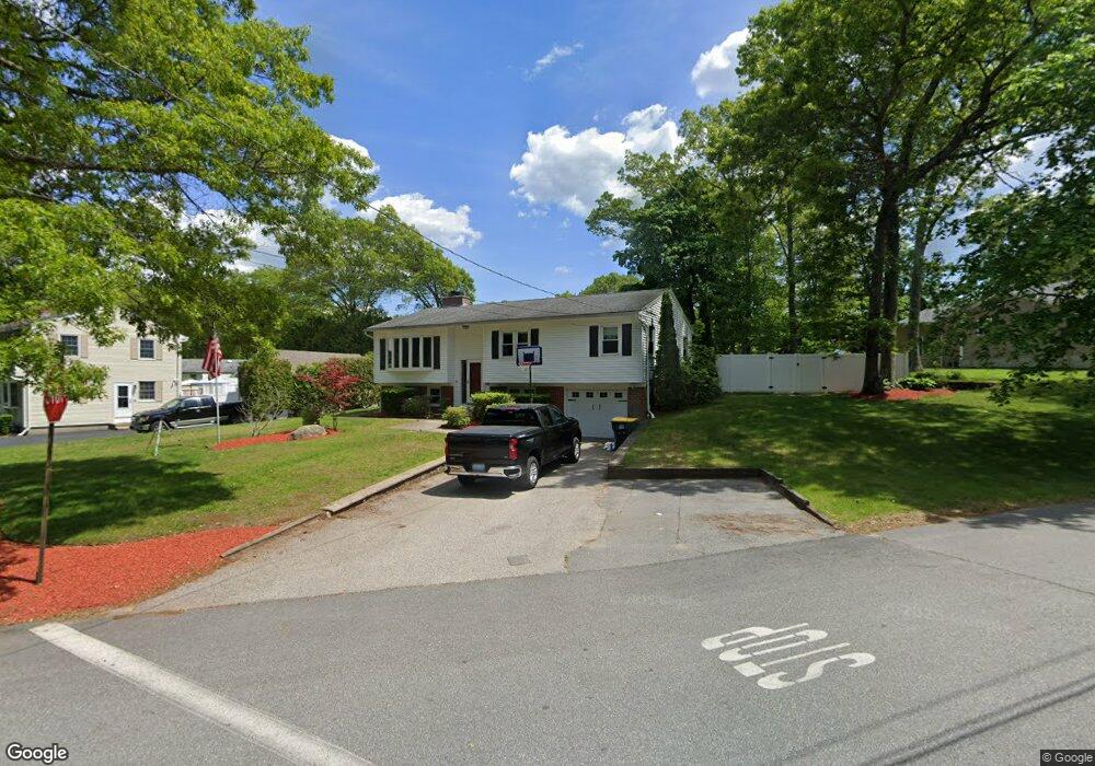
2 Carol Ann Ave Smithfield, RI 02917
Estimated Value: $470,109 - $586,000
3
Beds
1
Bath
1,600
Sq Ft
$326/Sq Ft
Est. Value
About This Home
This home is located at 2 Carol Ann Ave, Smithfield, RI 02917 and is currently estimated at $521,777, approximately $326 per square foot. 2 Carol Ann Ave is a home located in Providence County with nearby schools including Raymond Laperche School, Vincent J. Gallagher Middle School, and Smithfield High School.
Ownership History
Date
Name
Owned For
Owner Type
Purchase Details
Closed on
Mar 5, 2019
Sold by
Mcgehearty Mark D
Bought by
Mcgehearty Ft and Mcgehearty
Current Estimated Value
Purchase Details
Closed on
Jan 17, 2007
Sold by
Lawton Michael T and Lawton Kerri Ann
Bought by
Mcgehearty Mark D
Home Financials for this Owner
Home Financials are based on the most recent Mortgage that was taken out on this home.
Original Mortgage
$273,000
Interest Rate
6.14%
Mortgage Type
Purchase Money Mortgage
Purchase Details
Closed on
Feb 26, 1998
Sold by
Dasilva Antonio L
Bought by
Pryor Lawton T and Pryor Kerri Ann
Create a Home Valuation Report for This Property
The Home Valuation Report is an in-depth analysis detailing your home's value as well as a comparison with similar homes in the area
Home Values in the Area
Average Home Value in this Area
Purchase History
| Date | Buyer | Sale Price | Title Company |
|---|---|---|---|
| Mcgehearty Ft | -- | -- | |
| Mcgehearty Ft | -- | -- | |
| Mcgehearty Ft | -- | -- | |
| Mcgehearty Mark D | $273,000 | -- | |
| Mcgehearty Mark D | $273,000 | -- | |
| Pryor Lawton T | $119,000 | -- | |
| Pryor Lawton T | $119,000 | -- |
Source: Public Records
Mortgage History
| Date | Status | Borrower | Loan Amount |
|---|---|---|---|
| Previous Owner | Pryor Lawton T | $273,000 | |
| Previous Owner | Pryor Lawton T | $164,000 | |
| Previous Owner | Pryor Lawton T | $139,000 |
Source: Public Records
Tax History
| Year | Tax Paid | Tax Assessment Tax Assessment Total Assessment is a certain percentage of the fair market value that is determined by local assessors to be the total taxable value of land and additions on the property. | Land | Improvement |
|---|---|---|---|---|
| 2025 | $5,035 | $406,400 | $153,300 | $253,100 |
| 2024 | $5,194 | $359,700 | $141,000 | $218,700 |
| 2023 | $4,935 | $359,700 | $141,000 | $218,700 |
| 2022 | $4,806 | $359,700 | $141,000 | $218,700 |
| 2021 | $4,903 | $286,200 | $128,200 | $158,000 |
| 2020 | $4,811 | $286,200 | $128,200 | $158,000 |
| 2019 | $4,811 | $286,200 | $128,200 | $158,000 |
| 2018 | $4,492 | $255,800 | $113,900 | $141,900 |
| 2017 | $4,492 | $255,800 | $113,900 | $141,900 |
| 2016 | $4,280 | $255,800 | $113,900 | $141,900 |
| 2015 | $4,206 | $239,400 | $103,400 | $136,000 |
| 2012 | $4,111 | $256,600 | $121,900 | $134,700 |
Source: Public Records
Map
Nearby Homes
- 2 Justin Cir Unit C
- 1 Stoneridge Rd
- 1 Stoneridge Rd Unit 1
- 35 Fenwood Ave
- 21 Cambridge Cir
- 5 Hill St Unit 3
- 61 Stillwater Rd
- 15 Higgins St Unit 311
- 15 Higgins St Unit 123
- 85 Stillwater Rd
- 18 Homestead Ave
- 407 Pinewood Dr
- 402 Pinewood Dr
- 85 Orchard Meadows Dr
- 1 Victoria Dr
- 16 Louise Ann Dr
- 14 Sables Way
- 5 Lacey Ct
- 5 Minoru St
- 4 Old County Village Way Unit B
Your Personal Tour Guide
Ask me questions while you tour the home.