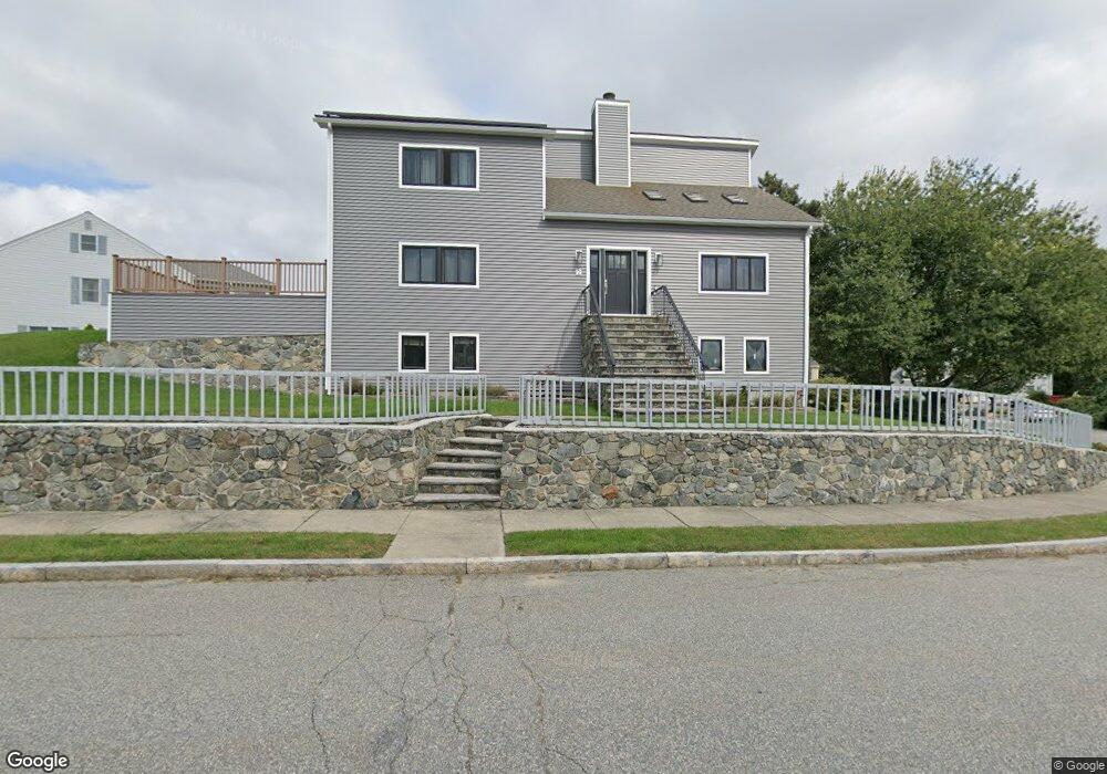
2 Daniel Dr Stoneham, MA 02180
Haywardville NeighborhoodEstimated Value: $1,083,000 - $1,199,000
3
Beds
2
Baths
3,190
Sq Ft
$359/Sq Ft
Est. Value
About This Home
This home is located at 2 Daniel Dr, Stoneham, MA 02180 and is currently estimated at $1,144,297, approximately $358 per square foot. 2 Daniel Dr is a home located in Middlesex County with nearby schools including Stoneham High School, Greater Boston Academy, and St. Patrick Elementary School.
Ownership History
Date
Name
Owned For
Owner Type
Purchase Details
Closed on
Jun 3, 2024
Sold by
Siegel Marci A
Bought by
Marci A Siegel 2013 T A and Marci Siegel
Current Estimated Value
Purchase Details
Closed on
Apr 1, 2015
Sold by
Leibovitz Marci A
Bought by
Sigel Marci A
Home Financials for this Owner
Home Financials are based on the most recent Mortgage that was taken out on this home.
Original Mortgage
$275,000
Interest Rate
3.75%
Mortgage Type
New Conventional
Purchase Details
Closed on
Dec 19, 1990
Sold by
Daniel Rt
Bought by
Leibovitz Marci A
Create a Home Valuation Report for This Property
The Home Valuation Report is an in-depth analysis detailing your home's value as well as a comparison with similar homes in the area
Home Values in the Area
Average Home Value in this Area
Purchase History
| Date | Buyer | Sale Price | Title Company |
|---|---|---|---|
| Marci A Siegel 2013 T A | -- | None Available | |
| Marci A Siegel 2013 T A | -- | None Available | |
| Sigel Marci A | -- | -- | |
| Sigel Marci A | -- | -- | |
| Leibovitz Marci A | $99,900 | -- |
Source: Public Records
Mortgage History
| Date | Status | Borrower | Loan Amount |
|---|---|---|---|
| Previous Owner | Sigel Marci A | $275,000 | |
| Previous Owner | Leibovitz Marci A | $132,000 | |
| Previous Owner | Leibovitz Marci A | $245,000 |
Source: Public Records
Tax History
| Year | Tax Paid | Tax Assessment Tax Assessment Total Assessment is a certain percentage of the fair market value that is determined by local assessors to be the total taxable value of land and additions on the property. | Land | Improvement |
|---|---|---|---|---|
| 2025 | $9,506 | $929,200 | $418,100 | $511,100 |
| 2024 | $8,818 | $832,700 | $380,100 | $452,600 |
| 2023 | $8,699 | $783,700 | $342,100 | $441,600 |
| 2022 | $7,742 | $743,700 | $332,600 | $411,100 |
| 2021 | $7,485 | $691,800 | $294,600 | $397,200 |
| 2020 | $7,430 | $688,600 | $294,600 | $394,000 |
| 2019 | $7,746 | $690,400 | $294,600 | $395,800 |
| 2018 | $7,691 | $656,800 | $275,600 | $381,200 |
| 2017 | $7,521 | $607,000 | $266,100 | $340,900 |
| 2016 | $7,308 | $575,400 | $266,100 | $309,300 |
| 2015 | $7,202 | $555,700 | $256,600 | $299,100 |
| 2014 | $6,875 | $509,600 | $223,400 | $286,200 |
Source: Public Records
Map
Nearby Homes
- 137 Franklin St Unit 102
- 159 Franklin St Unit D2
- 159 Franklin St Unit C2
- 159 Franklin St Unit E6
- 17 Franklin St
- 53 Perkins St
- 6 Everett St
- 33 Lake Ave
- 35 Wright St
- 57 Park St
- 8 Common St Unit 3
- 132 Walton Park
- 51 Spring St
- 10 Pomeworth St Unit A
- 35 Maple Rd
- 300 Park Terrace Dr Unit 354
- 4 Garfield Ave
- 35 Tremont St
- 11 Ludlow Ave
- 15 Brookbridge Rd
- 5 Daniel Dr
- 25 Dapper Darby Dr
- 3 Daniel Dr
- 23 Dapper Darby Dr
- 3 Roberts Way
- 27 Dapper Darby Dr
- 18 Dapper Darby Dr
- 20 Dapper Darby Dr
- 6 Daniel Dr
- 8 Roberts Way
- 21 Dapper Darby Dr
- 7 Daniel Dr
- 16 Dapper Darby Dr
- 29 Dapper Darby Dr
- 19 Dapper Darby Dr
- 6 Roberts Way
- 22 Dapper Darby Dr
- 14 Dapper Darby Dr
- 4 Roberts Way
- 31 Dapper Darby Dr
Your Personal Tour Guide
Ask me questions while you tour the home.