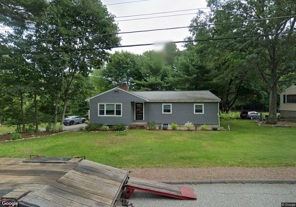
2 Gowing Rd Wilmington, MA 01887
Estimated Value: $644,000 - $724,000
3
Beds
1
Bath
1,434
Sq Ft
$476/Sq Ft
Est. Value
About This Home
This home is located at 2 Gowing Rd, Wilmington, MA 01887 and is currently estimated at $682,936, approximately $476 per square foot. 2 Gowing Rd is a home located in Middlesex County with nearby schools including Wilmington Middle School, Wilmington High School, and N Reading Knowledge Beginnings.
Ownership History
Date
Name
Owned For
Owner Type
Purchase Details
Closed on
Apr 13, 2022
Sold by
Derrico Michael F
Bought by
Derrico Michael F and Derrico Kimberly A
Current Estimated Value
Home Financials for this Owner
Home Financials are based on the most recent Mortgage that was taken out on this home.
Original Mortgage
$120,000
Outstanding Balance
$83,953
Interest Rate
3.76%
Mortgage Type
Stand Alone Refi Refinance Of Original Loan
Estimated Equity
$598,983
Purchase Details
Closed on
Jul 23, 1998
Sold by
Est Derrico Michael and Dyjak Annette
Bought by
Derrico Michael F
Home Financials for this Owner
Home Financials are based on the most recent Mortgage that was taken out on this home.
Original Mortgage
$112,000
Interest Rate
6.99%
Mortgage Type
Purchase Money Mortgage
Create a Home Valuation Report for This Property
The Home Valuation Report is an in-depth analysis detailing your home's value as well as a comparison with similar homes in the area
Home Values in the Area
Average Home Value in this Area
Purchase History
| Date | Buyer | Sale Price | Title Company |
|---|---|---|---|
| Derrico Michael F | -- | None Available | |
| Derrico Michael F | $140,000 | -- | |
| Derrico Michael F | $140,000 | -- |
Source: Public Records
Mortgage History
| Date | Status | Borrower | Loan Amount |
|---|---|---|---|
| Open | Derrico Michael F | $120,000 | |
| Previous Owner | Derrico Michael F | $112,000 |
Source: Public Records
Tax History Compared to Growth
Tax History
| Year | Tax Paid | Tax Assessment Tax Assessment Total Assessment is a certain percentage of the fair market value that is determined by local assessors to be the total taxable value of land and additions on the property. | Land | Improvement |
|---|---|---|---|---|
| 2025 | $6,544 | $571,500 | $331,500 | $240,000 |
| 2024 | $6,317 | $552,700 | $331,500 | $221,200 |
| 2023 | $6,110 | $511,700 | $301,600 | $210,100 |
| 2022 | $5,766 | $442,500 | $251,200 | $191,300 |
| 2021 | $5,762 | $416,300 | $228,200 | $188,100 |
| 2020 | $5,549 | $408,600 | $228,200 | $180,400 |
| 2019 | $5,499 | $399,900 | $217,200 | $182,700 |
| 2018 | $5,182 | $359,600 | $206,700 | $152,900 |
| 2017 | $5,036 | $348,500 | $206,700 | $141,800 |
| 2016 | $4,984 | $340,700 | $196,800 | $143,900 |
| 2015 | $4,723 | $328,700 | $196,800 | $131,900 |
| 2014 | $4,393 | $308,500 | $187,400 | $121,100 |
Source: Public Records
Map
Nearby Homes
- 7 W Village Dr
- 12 Lockwood Rd
- 5 Flynn Way
- 220 Martins Landing Unit 309
- 260 Martins Landing Unit 508
- 260 Martins Landing Unit 103
- 300 Martins Landing Unit 107
- 320 Martins Landing Unit 108
- 320 Martins Landing Unit 109
- 320 Martins Landing Unit 110
- 320 Martins Landing Unit 303
- 320 Martins Landing Unit 102
- 320 Martins Landing Unit 103
- 320 Martins Landing Unit 2410
- 320 Martins Landing Unit 403
- 320 Martins Landing Unit 2201
- 320 Martins Landing Unit 112
- 320 Martins Landing Unit 206
- 320 Martins Landing Unit 2307
- 320 Martins Landing Unit 302