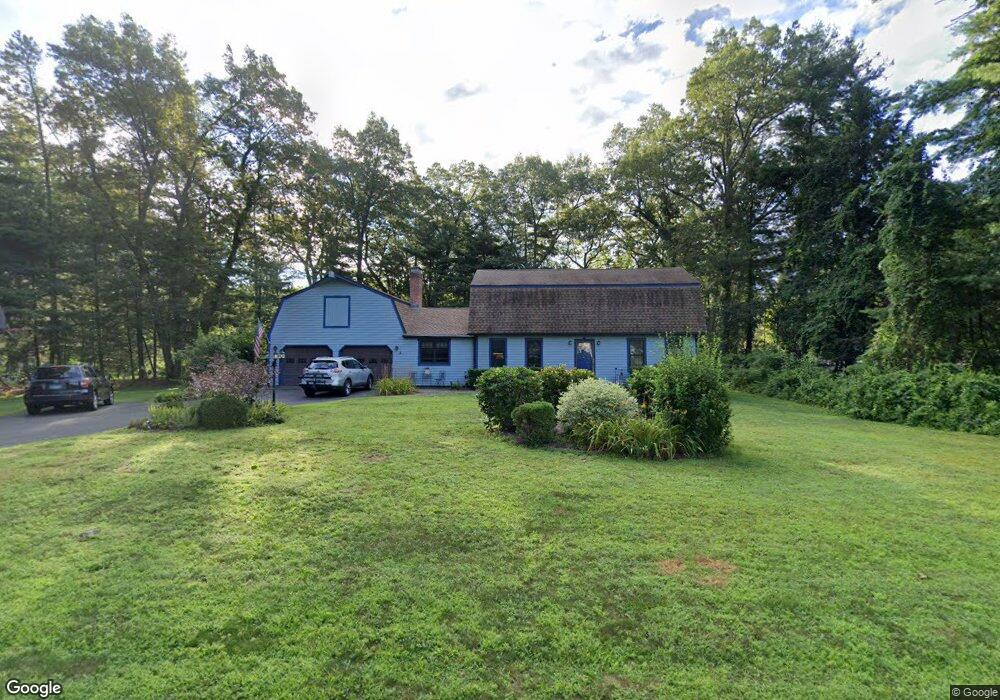
2 Halwood Dr Granby, CT 06035
Estimated Value: $520,093 - $589,000
3
Beds
3
Baths
1,992
Sq Ft
$273/Sq Ft
Est. Value
About This Home
This home is located at 2 Halwood Dr, Granby, CT 06035 and is currently estimated at $544,273, approximately $273 per square foot. 2 Halwood Dr is a home located in Hartford County with nearby schools including Kelly Lane Primary School, Granby Memorial Middle School, and Granby Memorial High School.
Ownership History
Date
Name
Owned For
Owner Type
Purchase Details
Closed on
Jul 27, 2001
Sold by
Barstow Carlton and Bastow Pamella
Bought by
Ziemnicki Jonathan and Ziemnicki Terri
Current Estimated Value
Home Financials for this Owner
Home Financials are based on the most recent Mortgage that was taken out on this home.
Original Mortgage
$180,000
Interest Rate
7.18%
Purchase Details
Closed on
Oct 29, 1987
Sold by
Hawley William
Bought by
Barstow Carlton
Create a Home Valuation Report for This Property
The Home Valuation Report is an in-depth analysis detailing your home's value as well as a comparison with similar homes in the area
Home Values in the Area
Average Home Value in this Area
Purchase History
| Date | Buyer | Sale Price | Title Company |
|---|---|---|---|
| Ziemnicki Jonathan | $225,000 | -- | |
| Ziemnicki Jonathan | $225,000 | -- | |
| Barstow Carlton | $213,000 | -- |
Source: Public Records
Mortgage History
| Date | Status | Borrower | Loan Amount |
|---|---|---|---|
| Open | Barstow Carlton | $150,000 | |
| Closed | Barstow Carlton | $180,000 | |
| Previous Owner | Barstow Carlton | $127,000 |
Source: Public Records
Tax History Compared to Growth
Tax History
| Year | Tax Paid | Tax Assessment Tax Assessment Total Assessment is a certain percentage of the fair market value that is determined by local assessors to be the total taxable value of land and additions on the property. | Land | Improvement |
|---|---|---|---|---|
| 2025 | $9,540 | $278,880 | $59,360 | $219,520 |
| 2024 | $9,239 | $278,880 | $59,360 | $219,520 |
| 2023 | $8,893 | $278,880 | $59,360 | $219,520 |
| 2022 | $8,150 | $203,840 | $51,310 | $152,530 |
| 2021 | $8,074 | $203,840 | $51,310 | $152,530 |
| 2020 | $8,074 | $203,840 | $51,310 | $152,530 |
| 2019 | $8,074 | $203,840 | $51,310 | $152,530 |
| 2018 | $7,887 | $203,840 | $51,310 | $152,530 |
| 2017 | $7,734 | $203,840 | $51,310 | $152,530 |
| 2016 | $7,530 | $203,840 | $51,310 | $152,530 |
| 2015 | $7,383 | $203,840 | $51,310 | $152,530 |
| 2014 | $7,240 | $203,840 | $51,310 | $152,530 |
Source: Public Records
Map
Nearby Homes
- 27 Brettonwood Dr Unit 27
- 14 Brettonwood Dr
- 7 Knollwood Cir
- 14 Gordon St
- 16 Berkshire Way
- 21 Berkshire Way
- 51 Canton Rd
- 16 Whytewood Ln
- 31 Hunt Glen Dr
- 77 Hunt Glen Dr
- 12 Gretel Ln
- 45 Hoskins Rd
- 324 Firetown Rd
- 11 Mallard Cir
- 2 Quail Dr Unit 2
- 14 Teal Cir Unit 14
- 19 Simsbury Landing
- 26 Winterset Ln
- 14 Main Street Extension
- 5 Anja Dr