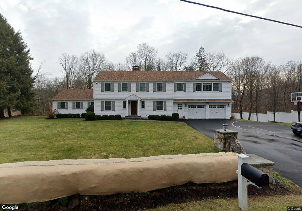
2 Hessian Dr Ridgefield, CT 06877
Estimated Value: $1,090,000 - $1,457,000
5
Beds
4
Baths
3,586
Sq Ft
$361/Sq Ft
Est. Value
About This Home
This home is located at 2 Hessian Dr, Ridgefield, CT 06877 and is currently estimated at $1,295,173, approximately $361 per square foot. 2 Hessian Dr is a home located in Fairfield County with nearby schools including Barlow Mountain Elementary School, Scotts Ridge Middle School, and Ridgefield High School.
Ownership History
Date
Name
Owned For
Owner Type
Purchase Details
Closed on
Jul 14, 2006
Sold by
Flippin Robert A and Flippin Jody K
Bought by
Fiore Michael H and Scanlon-Fiore Heather
Current Estimated Value
Purchase Details
Closed on
Oct 12, 1999
Sold by
Andrews Richard
Bought by
Flippin Robert A and Flippin Jody K
Purchase Details
Closed on
Mar 2, 1998
Sold by
Pollack Mark H and Pollack Barbara M
Bought by
Andrews Richard
Purchase Details
Closed on
Jun 30, 1989
Sold by
Edwards George
Bought by
Pollack Mark
Create a Home Valuation Report for This Property
The Home Valuation Report is an in-depth analysis detailing your home's value as well as a comparison with similar homes in the area
Home Values in the Area
Average Home Value in this Area
Purchase History
| Date | Buyer | Sale Price | Title Company |
|---|---|---|---|
| Fiore Michael H | $700,000 | -- | |
| Flippin Robert A | $420,000 | -- | |
| Andrews Richard | $362,500 | -- | |
| Pollack Mark | $285,000 | -- |
Source: Public Records
Mortgage History
| Date | Status | Borrower | Loan Amount |
|---|---|---|---|
| Open | Pollack Mark | $493,000 | |
| Closed | Pollack Mark | $544,000 |
Source: Public Records
Tax History Compared to Growth
Tax History
| Year | Tax Paid | Tax Assessment Tax Assessment Total Assessment is a certain percentage of the fair market value that is determined by local assessors to be the total taxable value of land and additions on the property. | Land | Improvement |
|---|---|---|---|---|
| 2025 | $19,186 | $700,490 | $204,750 | $495,740 |
| 2024 | $18,458 | $700,490 | $204,750 | $495,740 |
| 2023 | $15,117 | $585,690 | $204,750 | $380,940 |
| 2022 | $15,777 | $554,930 | $157,500 | $397,430 |
| 2021 | $15,655 | $554,930 | $157,500 | $397,430 |
| 2020 | $15,605 | $554,930 | $157,500 | $397,430 |
| 2019 | $14,710 | $523,100 | $157,500 | $365,600 |
| 2018 | $13,657 | $491,600 | $157,500 | $334,100 |
| 2017 | $13,602 | $499,890 | $155,230 | $344,660 |
| 2016 | $13,342 | $499,890 | $155,230 | $344,660 |
| 2015 | $11,652 | $448,000 | $155,230 | $292,770 |
| 2014 | $11,652 | $448,000 | $155,230 | $292,770 |
Source: Public Records
Map
Nearby Homes
- 358 N Salem Rd
- 463 N Salem Rd
- 261 North St
- 31 Ridgecrest Dr
- 23 Pond Rd
- 88 Green Ln
- 10 Hillcrest Ct
- 151 North St
- 22 Ketcham Rd
- 7 Craigmoor Rd S
- 217 Danbury Rd
- 213 Mamanasco Rd
- 415 Barrack Hill Rd
- 7 Honeysuckle Ln
- 7 Elderberry Ln Unit 7
- 40 North St
- 83 Aspen Ledges Rd
- 33 N Salem Rd
- 75A New St
- 75 New St
- 15 Hessian Dr
- 7 Hessian Dr
- 10 Hessian Dr
- 374 N Salem Rd
- 14 Hessian Dr
- 25 Hessian Dr
- 359 N Salem Rd
- 393 N Salem Rd
- 394 N Salem Rd
- 20 Hessian Dr
- 402 N Salem Rd
- 14 High Pastures Ct
- 24 Hessian Dr
- 395 N Salem Rd
- 39 Tannery Hill Rd
- 20 High Pastures Ct
- 348 N Salem Rd
- 46 Tannery Hill Rd
- 410 N Salem Rd
- 345 N Salem Rd