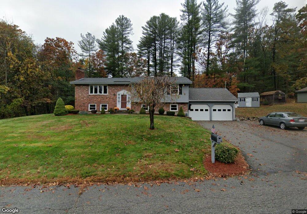
2 James Rd Ipswich, MA 01938
Estimated Value: $708,000 - $774,000
4
Beds
2
Baths
1,996
Sq Ft
$368/Sq Ft
Est. Value
About This Home
This home is located at 2 James Rd, Ipswich, MA 01938 and is currently estimated at $734,063, approximately $367 per square foot. 2 James Rd is a home located in Essex County with nearby schools including Ipswich High School and Clark School.
Ownership History
Date
Name
Owned For
Owner Type
Purchase Details
Closed on
Oct 28, 2005
Sold by
Knight Arthur A
Bought by
Mackey David S and Mackey Debra P
Current Estimated Value
Home Financials for this Owner
Home Financials are based on the most recent Mortgage that was taken out on this home.
Original Mortgage
$150,000
Outstanding Balance
$79,948
Interest Rate
5.79%
Mortgage Type
Purchase Money Mortgage
Estimated Equity
$654,115
Purchase Details
Closed on
Aug 24, 1998
Sold by
Funchion Peter M and Funchion Cheryl A
Bought by
Knight Arthur A
Create a Home Valuation Report for This Property
The Home Valuation Report is an in-depth analysis detailing your home's value as well as a comparison with similar homes in the area
Home Values in the Area
Average Home Value in this Area
Purchase History
| Date | Buyer | Sale Price | Title Company |
|---|---|---|---|
| Mackey David S | $471,000 | -- | |
| Mackey David S | $471,000 | -- | |
| Knight Arthur A | $225,000 | -- | |
| Knight Arthur A | $225,000 | -- |
Source: Public Records
Mortgage History
| Date | Status | Borrower | Loan Amount |
|---|---|---|---|
| Open | Knight Arthur A | $150,000 | |
| Closed | Knight Arthur A | $150,000 |
Source: Public Records
Tax History
| Year | Tax Paid | Tax Assessment Tax Assessment Total Assessment is a certain percentage of the fair market value that is determined by local assessors to be the total taxable value of land and additions on the property. | Land | Improvement |
|---|---|---|---|---|
| 2025 | $6,683 | $599,400 | $314,900 | $284,500 |
| 2024 | $6,546 | $575,200 | $314,900 | $260,300 |
| 2023 | $6,612 | $540,600 | $290,400 | $250,200 |
| 2022 | $6,310 | $490,700 | $265,900 | $224,800 |
| 2021 | $6,175 | $467,100 | $253,700 | $213,400 |
| 2020 | $6,116 | $436,200 | $241,400 | $194,800 |
| 2019 | $5,952 | $422,400 | $229,200 | $193,200 |
| 2018 | $5,769 | $405,100 | $217,000 | $188,100 |
| 2017 | $5,422 | $382,100 | $199,500 | $182,600 |
| 2016 | $5,322 | $358,400 | $199,500 | $158,900 |
| 2015 | $4,691 | $347,200 | $192,500 | $154,700 |
Source: Public Records
Map
Nearby Homes
- 75 Country Club Way
- 196 Country Club Way
- 76-78 Daniels Rd
- 4 Sheppards Way
- 17 Arthur Gordon Dr
- 38 Buttonwood
- 38 Buttonwood Unit 30
- 30 Buttonwood
- 480 Newburyport Turnpike
- 460 - 472 Newburyport Turnpike
- 16 Fairway Dr Unit 16
- 45 Pineswamp Rd
- 34 Central St Unit 2
- 34 Central St Unit 1
- 54 Willowdale Rd
- 37 East St
- 304-312 Wethersfield St
- 308 & 312 Wethersfield St
- 870 Haverhill St Unit 2B
- 870 Haverhill St Unit 21B
Your Personal Tour Guide
Ask me questions while you tour the home.