NOT LISTED FOR SALE

2 Jeremysquam Way Westport Island, ME 04578

Estimated Value: $811,000 - $1,521,000

2.9 Acres
$424,654 Price per Acre
126,324 Sq Ft Lot

Last Sold September 10, 2020

Last sale price $132,000

Est. 833% increase in value since last sale

Current estimated payment $7,431/month

708 Days on Market

Highlights

  • Deeded Waterfront Access Rights
  • Island Location
  • No HOA
  • 311 Feet of Waterfront
  • Wooded Lot
  • Lot Has A Rolling Slope

About This Lot

As of September 2020

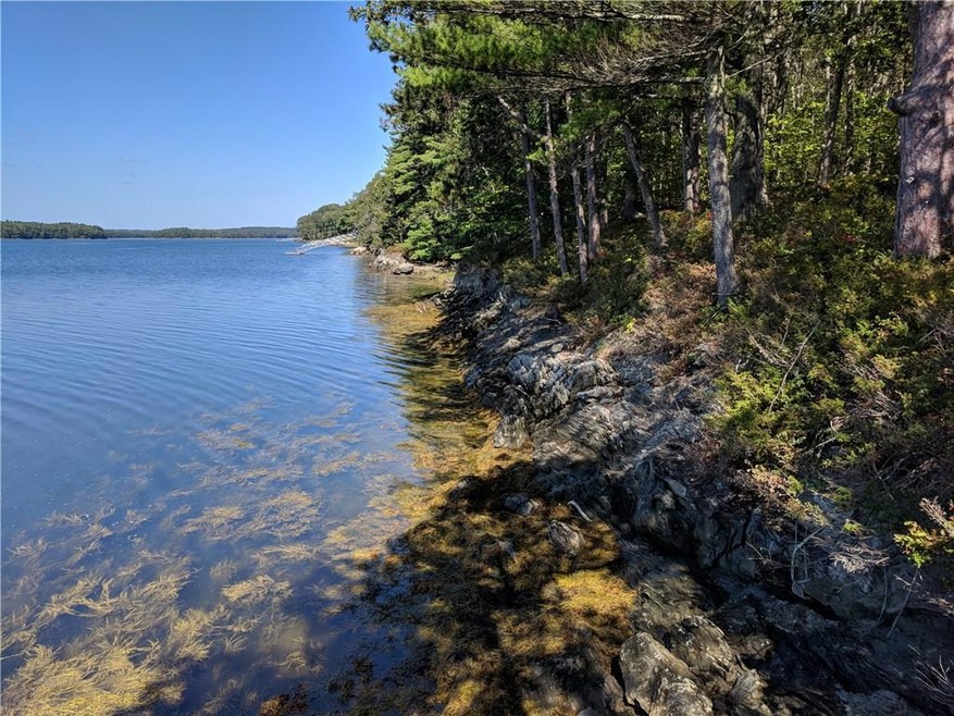
Let's start with the basics. Western facing waterfront that gently slopes to the shores of the salty waters of Montsweag Bay Rocky waterfront that ebbs and flows with the tides. Plenty of room for a dingy dock that will rest on mud on each turn of the tide. Ideal for canoeing, kayaking and early morning paddle boarding. The shallow nature of the western shore of Westport Island means warmer water swimming, no discernible current, less traffic and spectacular bird watching. Rambling stonewalls and multiple house site options make this 2.9 +/- ac parcel the ideal setting for your new home or get away.

Last Agent to Sell the Property

Poe Cilley

Vitalius Real Estate Group Brokerage Phone: 8886998876 Listed on: 09/20/2019

Last Buyer's Agent

Poe Cilley

CHR Realty

Property Details

Property Type

  • Land

Est. Annual Taxes

  • $2,199

Lot Details

  • 2.9 Acre Lot
  • 311 Feet of Waterfront
  • Property Fronts a Bay or Harbor
  • Property fronts a private road
  • Dirt Road
  • Rural Setting
  • Lot Has A Rolling Slope
  • Wooded Lot
  • Property is zoned rural

Parking

  • Gravel Driveway

Property Views

  • Water
  • Scenic Vista

Utilities

  • Electricity Not Available
  • Natural Gas Not Available
  • Water Not Available
  • Private Water Source
  • Well Required
  • Septic Needed
  • Sewer Not Available
  • Private Sewer

Additional Features

  • Island Location
  • Mobile Home Allowed

Listing and Financial Details

  • Tax Lot 7.1A
  • Assessor Parcel Number WPRR-000005-000000-000007-000001

Community Details

Overview

  • No Home Owners Association

Recreation

  • Deeded Waterfront Access Rights
  • Access to Tidal Water
  • River Nearby

Property Details

Property Type

Land

Est. Annual Taxes

$2,199

Lot Details

0

Listing Details

  • Prop. Type: Land
  • Lot Size Acres: 2.9
  • Road Frontage Type: Private
  • Road Surface Type: Gravel
  • Water Body Name: Montsweag Bay
  • MLS Status: Closed
  • Directions: Birch Point Road, Wiscasset to Westport Bridge Road (Rte.144 south). Follow approx. 4.9 miles to Jeremysquam Way. Turn into 4 Jeremysquam's driveway and bear right into the turn off.
  • Attribution Contact: 8886998876
  • Property Information:Lot Size Acres -: 2.9
  • Water Info:Water Frontage2: Yes
  • Water Info:Water View2: Yes
  • Roads:Private: Yes
  • Gas:No Gas: Yes
  • Sewer:Private Sewer: Yes
  • Recreational Water:RiverBrookStream: Yes
  • Location:Rural: Yes
  • Water Info:Waterfront Amount -: 311.0
  • Water Info:Water Frontage Owned -: 311.0
  • Recreational Water:Deeded: Yes
  • Water:Private2: Yes
  • Driveway:Gravel: Yes
  • Site:Wooded: Yes
  • Site:RollingSloping: Yes
  • Driveway:No Driveway: Yes
  • Property Information:Bank Owned REO: No
  • View:Scenic: Yes
  • Property Information:Mobile Homes Allowed: Yes
  • Electric:No Electric: Yes
  • Sewer:None4: Yes
  • Water:Well Needed on Site: Yes
  • Recreational Water:Waterfront Tidal: Yes
  • Sewer:Septic Needed: Yes
  • Water Info:Island3: Yes
  • Special Features: None
  • Property Sub Type: LotsLands

Exterior Features

  • Lot Features: Rolling Slope, Wooded, Rural
  • View: Scenic
  • Waterfront Features: Bay
  • Waterfront: Yes

Garage/Parking

  • Parking Features: No Driveway, Gravel

Utilities

  • Electric: No Electric
  • Sewer: None, Private Sewer, Septic Needed
  • Water Source: Private, Well Needed on Site, None

Condo/Co-op/Association

  • Association: No

Lot Info

  • Lot Size Sq Ft: 126324.0
  • Parcel #: WPRR-000005-000000-000007-000001
  • Zoning: rural

Tax Info

  • Tax Annual Amount: 2199.0
  • Tax Book Number: 3943
  • Tax Lot: 7.1A
  • Tax Map Number: 5A
  • Tax Year: 2017

Range of Values:

Collateral Analytics

Collateral Analytics Collateral Analytics AVMs (Automated Valuation Model) employ a number of statistical approaches combined with neighborhood-specific comparable selection guarantees the most up-to-date and precise valuations.

Not Available

Collateral Analytics does not have data for the current month. Please view the chart for historical values.

ICE

ICE Mortgage Technology ICE Mortgage Technology’s AVM (Automated Valuation Model) is a state-of-the-art online residential property valuation tool that provides a quick and accurate estimate of the value of almost any home in the U.S.

Not Available

ICE Mortgage Technology does not have data for the current month. Please view the chart for historical values.

First American

First American First American Data & Analytics’ next-generation AVM combines unrivaled data assets with a blended ensemble of valuation models to produce highly accurate, reliable valuations you can trust.

Not Available

First American does not have data for the current month. Please view the chart for historical values.

Quantarium

Quantarium Quantarium’s valuation service, repeatedly proven the industry’s most accurate and comprehensive, is supercharged with a self-learning and auto-tuning AI engine that continually becomes smarter and more accurate as it processes daily inputs from the industry’s leading RE data lake.

Not Available

Quantarium does not have data for the current month. Please view the chart for historical values.

Average Value
Not Available
List Price
Sold Price
Create a Home Valuation Report for This Property
The Home Valuation Report is an in-depth analysis detailing your home's value as well as a comparison with similar homes in the area

Home Values in the Area

Source: Public Records

Average Home Value in this Area


Source: Public Records

Mortgage History

Date Status Borrower Loan Amount
Closed Graff Ft $750,000
Source: Public Records

Property History

Date Event Price Change Sq Ft Price
09/10/2020 09/10/20 Sold $132,000 -17.5% --
08/27/2020 08/27/20 Pending -- -- --
09/18/2018 09/18/18 For Sale $160,000 -- --
Source: Maine Listings

Tax History Compared to Growth

Source: Public Records

Tax History

Year Tax Paid Tax Assessment Tax Assessment Total Assessment is a certain percentage of the fair market value that is determined by local assessors to be the total taxable value of land and additions on the property. Land Improvement
2024 $6,857 $926,605 $424,179 $502,426
2023 $6,046 $923,025 $420,599 $502,426
2022 $6,280 $756,578 $344,754 $411,824
2021 $2,740 $346,806 $333,254 $13,552
2020 $2,699 $333,254 $333,254 $0
2019 $2,489 $333,254 $333,254 $0
2018 $2,199 $333,254 $333,254 $0
2016 $2,399 $333,254 $333,254 $0
2014 $2,805 $373,526 $0 $0
2013 $2,895 $373,526 $373,526 $0
Source: Public Records

Agents Affiliated with this Home

  • Section Image
See All Agents

Map

Source: Maine Listings

MLS Number: 1369588

Maine Listings

APN: WPRR-000005-000000-000007-000001