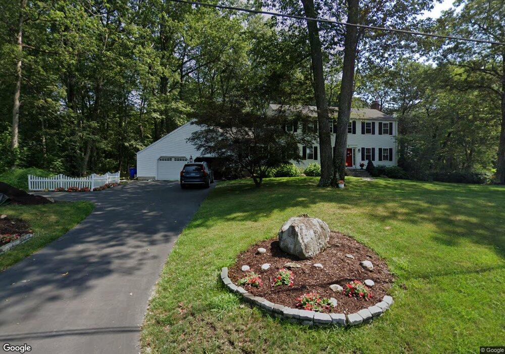
2 Katherine Ln Simsbury, CT 06070
Estimated Value: $629,000 - $700,685
4
Beds
4
Baths
2,242
Sq Ft
$301/Sq Ft
Est. Value
About This Home
This home is located at 2 Katherine Ln, Simsbury, CT 06070 and is currently estimated at $674,421, approximately $300 per square foot. 2 Katherine Ln is a home located in Hartford County with nearby schools including Squadron Line School, Henry James Memorial School, and Simsbury High School.
Ownership History
Date
Name
Owned For
Owner Type
Purchase Details
Closed on
May 10, 2005
Sold by
Keaton Michael R and Keaton Kimberly M
Bought by
Curtiss Andrew W and Curtiss Mary K
Current Estimated Value
Purchase Details
Closed on
Dec 9, 2002
Sold by
Wilcox John B and Wilcox Audrey A
Bought by
Keaton Michael R and Keaton Kimberly M
Purchase Details
Closed on
Jan 24, 1997
Sold by
Guay Paul and Guay Katherine
Bought by
Wilcox John and Wilcox Audrey
Purchase Details
Closed on
Dec 27, 1994
Sold by
Walker Thomas
Bought by
Guay Paul and Cuay Katherine
Purchase Details
Closed on
Jul 14, 1988
Sold by
Mcdermott Daniel
Bought by
Walker Thomas
Create a Home Valuation Report for This Property
The Home Valuation Report is an in-depth analysis detailing your home's value as well as a comparison with similar homes in the area
Home Values in the Area
Average Home Value in this Area
Purchase History
| Date | Buyer | Sale Price | Title Company |
|---|---|---|---|
| Curtiss Andrew W | $409,900 | -- | |
| Keaton Michael R | $370,000 | -- | |
| Wilcox John | $255,000 | -- | |
| Walker Thomas | $314,000 | -- | |
| Guay Paul | $250,000 | -- |
Source: Public Records
Mortgage History
| Date | Status | Borrower | Loan Amount |
|---|---|---|---|
| Open | Walker Thomas | $376,000 | |
| Closed | Walker Thomas | $360,800 |
Source: Public Records
Tax History Compared to Growth
Tax History
| Year | Tax Paid | Tax Assessment Tax Assessment Total Assessment is a certain percentage of the fair market value that is determined by local assessors to be the total taxable value of land and additions on the property. | Land | Improvement |
|---|---|---|---|---|
| 2025 | $11,911 | $348,670 | $102,410 | $246,260 |
| 2024 | $11,614 | $348,670 | $102,410 | $246,260 |
| 2023 | $11,095 | $348,670 | $102,410 | $246,260 |
| 2022 | $10,182 | $263,580 | $109,720 | $153,860 |
| 2021 | $10,182 | $263,580 | $109,720 | $153,860 |
| 2020 | $9,776 | $263,580 | $109,720 | $153,860 |
| 2019 | $9,837 | $263,580 | $109,720 | $153,860 |
| 2018 | $9,908 | $263,580 | $109,720 | $153,860 |
| 2017 | $9,542 | $246,180 | $107,540 | $138,640 |
| 2016 | $9,138 | $246,180 | $107,540 | $138,640 |
| 2015 | $9,138 | $246,180 | $107,540 | $138,640 |
| 2014 | $9,143 | $246,180 | $107,540 | $138,640 |
Source: Public Records
Map
Nearby Homes
- 324 Firetown Rd
- 5 Anja Dr
- 303 Firetown Rd
- 12 Gretel Ln
- 16 Berkshire Way
- 21 Berkshire Way
- 35 Haven Dr
- 40 Holcomb St
- 16 Lionel Dr
- 15 Knollwood Cir
- 230 Firetown Rd
- 33 Whitman Dr
- 26 Winterset Ln
- 45 Hoskins Rd
- 55 Musket Trail
- 247 Old Farms Rd
- 27 Brettonwood Dr Unit 27
- 49 Brettonwood Dr Unit 49
- 14 Brettonwood Dr
- 9 Kerr Farm Rd