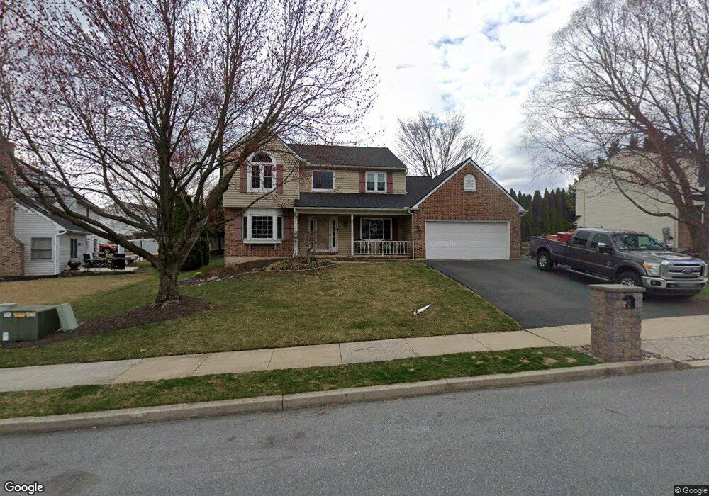
2 Katie Ln Mohnton, PA 19540
Estimated Value: $357,000 - $491,000
4
Beds
3
Baths
2,006
Sq Ft
$208/Sq Ft
Est. Value
About This Home
This home is located at 2 Katie Ln, Mohnton, PA 19540 and is currently estimated at $417,210, approximately $207 per square foot. 2 Katie Ln is a home located in Berks County with nearby schools including Governor Mifflin Intermediate School, Brecknock Elementary School, and Governor Mifflin Middle School.
Ownership History
Date
Name
Owned For
Owner Type
Purchase Details
Closed on
Nov 23, 2018
Sold by
Rouleau John A and Rouleau Debra M
Bought by
Rouleau Debra M
Current Estimated Value
Home Financials for this Owner
Home Financials are based on the most recent Mortgage that was taken out on this home.
Original Mortgage
$175,500
Outstanding Balance
$154,317
Interest Rate
4.8%
Mortgage Type
New Conventional
Estimated Equity
$262,893
Purchase Details
Closed on
May 15, 2006
Sold by
Corey Michael and Corey Leslie
Bought by
Rouleau John A and Rouleau Debra M
Home Financials for this Owner
Home Financials are based on the most recent Mortgage that was taken out on this home.
Original Mortgage
$10,000
Interest Rate
6.53%
Mortgage Type
Credit Line Revolving
Purchase Details
Closed on
Aug 28, 2003
Sold by
Calder Peter D and Calder Sharon Zache
Bought by
Corey Michael and Corey Leslie
Home Financials for this Owner
Home Financials are based on the most recent Mortgage that was taken out on this home.
Original Mortgage
$170,000
Interest Rate
5.25%
Mortgage Type
Purchase Money Mortgage
Create a Home Valuation Report for This Property
The Home Valuation Report is an in-depth analysis detailing your home's value as well as a comparison with similar homes in the area
Home Values in the Area
Average Home Value in this Area
Purchase History
| Date | Buyer | Sale Price | Title Company |
|---|---|---|---|
| Rouleau Debra M | -- | Edge Abstract | |
| Rouleau John A | $274,900 | None Available | |
| Corey Michael | $219,000 | Fidelity Natl Title Ins Co |
Source: Public Records
Mortgage History
| Date | Status | Borrower | Loan Amount |
|---|---|---|---|
| Open | Rouleau Debra M | $175,500 | |
| Closed | Rouleau John A | $10,000 | |
| Closed | Rouleau John A | $219,900 | |
| Previous Owner | Corey Michael | $170,000 | |
| Closed | Corey Michael | $27,100 |
Source: Public Records
Tax History
| Year | Tax Paid | Tax Assessment Tax Assessment Total Assessment is a certain percentage of the fair market value that is determined by local assessors to be the total taxable value of land and additions on the property. | Land | Improvement |
|---|---|---|---|---|
| 2025 | $3,067 | $183,500 | $29,900 | $153,600 |
| 2024 | $8,348 | $183,500 | $29,900 | $153,600 |
| 2023 | $8,130 | $183,500 | $29,900 | $153,600 |
| 2022 | $7,791 | $183,500 | $29,900 | $153,600 |
| 2021 | $7,699 | $183,500 | $29,900 | $153,600 |
| 2020 | $7,699 | $183,500 | $29,900 | $153,600 |
| 2019 | $7,571 | $183,500 | $29,900 | $153,600 |
| 2018 | $7,410 | $183,500 | $29,900 | $153,600 |
| 2017 | $7,261 | $183,500 | $29,900 | $153,600 |
| 2016 | $2,144 | $183,500 | $29,900 | $153,600 |
| 2015 | $2,144 | $183,500 | $29,900 | $153,600 |
| 2014 | $2,099 | $183,500 | $29,900 | $153,600 |
Source: Public Records
Map
Nearby Homes
- 508 Sycamore Rd
- 4 Katie Ln
- 3 Buck Run
- 506 Sycamore Rd
- 5 Buck Run
- 3 Katie Ln
- 5 Katie Ln
- 6 Katie Ln
- 602 Sycamore Rd
- 511 Sycamore Rd
- 1 Oak Ln
- 2 Buck Run
- 8 Katie Ln
- 601 Sycamore Rd
- 7 Katie Ln
- 4 Buck Run
- 504 Sycamore Rd
- 0 Buck Run Unit 1003292525
- 0 Buck Run Unit 105 1007221630
- 0 Buck Run Unit 200 1007178384
Your Personal Tour Guide
Ask me questions while you tour the home.