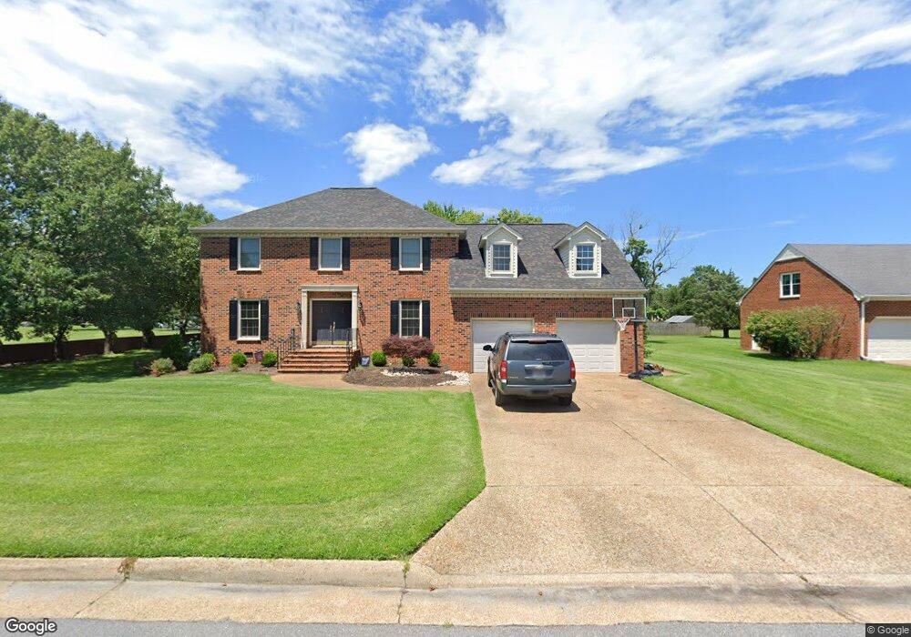
2 Lessies Dr Poquoson, VA 23662
Poquoson West NeighborhoodEstimated Value: $591,483 - $724,000
4
Beds
3
Baths
2,732
Sq Ft
$242/Sq Ft
Est. Value
About This Home
This home is located at 2 Lessies Dr, Poquoson, VA 23662 and is currently estimated at $660,371, approximately $241 per square foot. 2 Lessies Dr is a home located in Poquoson City with nearby schools including Emmanuel Lutheran School and Summit Christian Academy - Upper School.
Ownership History
Date
Name
Owned For
Owner Type
Purchase Details
Closed on
May 2, 2005
Sold by
Dedmond Scott J
Bought by
Sealey Shannon L
Current Estimated Value
Home Financials for this Owner
Home Financials are based on the most recent Mortgage that was taken out on this home.
Original Mortgage
$302,000
Interest Rate
5.79%
Mortgage Type
New Conventional
Purchase Details
Closed on
Sep 3, 2003
Sold by
Stutt Michael C
Bought by
Dedmond Scott J
Home Financials for this Owner
Home Financials are based on the most recent Mortgage that was taken out on this home.
Original Mortgage
$282,568
Interest Rate
6.02%
Mortgage Type
New Conventional
Create a Home Valuation Report for This Property
The Home Valuation Report is an in-depth analysis detailing your home's value as well as a comparison with similar homes in the area
Home Values in the Area
Average Home Value in this Area
Purchase History
| Date | Buyer | Sale Price | Title Company |
|---|---|---|---|
| Sealey Shannon L | $454,000 | -- | |
| Dedmond Scott J | $314,000 | -- |
Source: Public Records
Mortgage History
| Date | Status | Borrower | Loan Amount |
|---|---|---|---|
| Previous Owner | Sealey Shannon L | $302,000 | |
| Previous Owner | Dedmond Scott J | $282,568 |
Source: Public Records
Tax History Compared to Growth
Tax History
| Year | Tax Paid | Tax Assessment Tax Assessment Total Assessment is a certain percentage of the fair market value that is determined by local assessors to be the total taxable value of land and additions on the property. | Land | Improvement |
|---|---|---|---|---|
| 2024 | $5,812 | $509,800 | $162,300 | $347,500 |
| 2023 | $5,659 | $509,800 | $162,300 | $347,500 |
| 2022 | $5,156 | $456,300 | $162,400 | $293,900 |
| 2021 | $5,156 | $456,300 | $162,400 | $293,900 |
| 2020 | -- | $410,000 | $162,400 | $247,600 |
| 2019 | -- | $410,000 | $162,400 | $247,600 |
| 2018 | -- | $410,000 | $162,400 | $247,600 |
| 2017 | -- | $410,000 | $162,400 | $247,600 |
| 2016 | -- | $410,000 | $162,400 | $247,600 |
| 2015 | -- | $421,200 | $162,400 | $258,800 |
| 2013 | -- | $421,200 | $162,400 | $258,800 |
Source: Public Records
Map
Nearby Homes
- 6 Lessies Dr
- 7 Carmines Ct
- 3 Carmines Ct
- 105 Rens Rd Unit 30
- 105 Rens Rd Unit 2
- 105 Rens Rd Unit 74
- 105 Rens Rd Unit Lot 48
- 62 Rens Rd
- 1.55ac Holloway Rd
- 21 Rens Rd
- 7 Quail Cove
- 1 Phillips Rd
- 15+AC Browns Neck Rd
- 718C Poquoson Ave
- 35 River Rd
- 41 W Sandy Point Rd
- 29 River Rd
- 10 Kathy Dr
- 208 Little Florida Rd
- 28 Pasture Rd