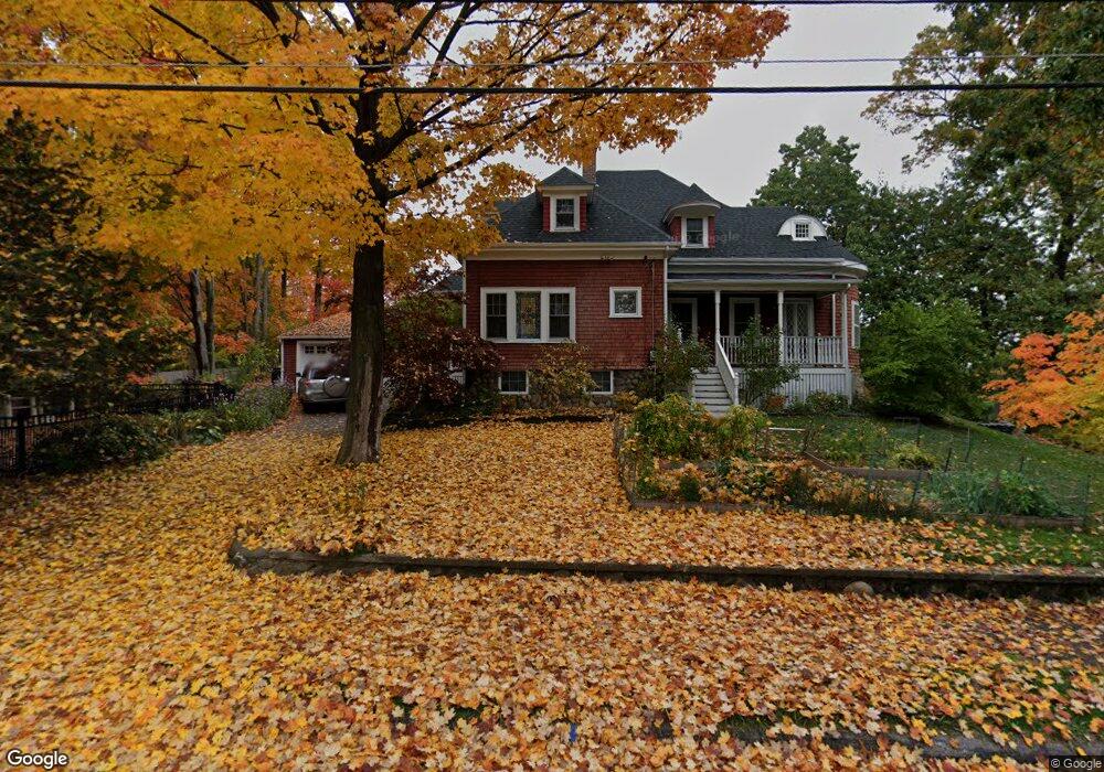
2 Nichols St Wakefield, MA 01880
West Side NeighborhoodEstimated Value: $846,000 - $974,000
5
Beds
2
Baths
2,246
Sq Ft
$404/Sq Ft
Est. Value
About This Home
This home is located at 2 Nichols St, Wakefield, MA 01880 and is currently estimated at $908,077, approximately $404 per square foot. 2 Nichols St is a home located in Middlesex County with nearby schools including Wakefield Memorial High School and St Joseph School.
Ownership History
Date
Name
Owned For
Owner Type
Purchase Details
Closed on
May 11, 2009
Sold by
Spillane David D and Spillane Cherly B
Bought by
Leras James and Leras Sofya
Current Estimated Value
Home Financials for this Owner
Home Financials are based on the most recent Mortgage that was taken out on this home.
Original Mortgage
$313,200
Interest Rate
4.9%
Mortgage Type
Purchase Money Mortgage
Purchase Details
Closed on
Jun 1, 1992
Sold by
Hartman Anthony G and Hartman Marianne
Bought by
Spillane David D and Spillane Cheryl B
Create a Home Valuation Report for This Property
The Home Valuation Report is an in-depth analysis detailing your home's value as well as a comparison with similar homes in the area
Home Values in the Area
Average Home Value in this Area
Purchase History
| Date | Buyer | Sale Price | Title Company |
|---|---|---|---|
| Leras James | $391,500 | -- | |
| Spillane David D | $222,000 | -- |
Source: Public Records
Mortgage History
| Date | Status | Borrower | Loan Amount |
|---|---|---|---|
| Open | Spillane David D | $302,000 | |
| Closed | Leras James | $313,200 | |
| Previous Owner | Spillane David D | $250,000 | |
| Previous Owner | Spillane David D | $200,000 |
Source: Public Records
Tax History Compared to Growth
Tax History
| Year | Tax Paid | Tax Assessment Tax Assessment Total Assessment is a certain percentage of the fair market value that is determined by local assessors to be the total taxable value of land and additions on the property. | Land | Improvement |
|---|---|---|---|---|
| 2025 | $8,501 | $749,000 | $413,000 | $336,000 |
| 2024 | $8,025 | $713,300 | $393,300 | $320,000 |
| 2023 | $7,810 | $665,800 | $367,100 | $298,700 |
| 2022 | $7,324 | $594,500 | $327,800 | $266,700 |
| 2021 | $6,837 | $537,100 | $306,500 | $230,600 |
| 2020 | $6,455 | $505,500 | $288,500 | $217,000 |
| 2019 | $6,253 | $487,400 | $278,100 | $209,300 |
| 2018 | $6,031 | $465,700 | $265,300 | $200,400 |
| 2017 | $5,891 | $452,100 | $257,500 | $194,600 |
| 2016 | $5,635 | $417,700 | $238,800 | $178,900 |
| 2015 | $5,520 | $409,500 | $234,100 | $175,400 |
| 2014 | $5,233 | $409,500 | $234,100 | $175,400 |
Source: Public Records
Map
Nearby Homes
- 90 Prospect St
- 95 Prospect St
- 34 Cedar St
- 40 Friend St
- 6 Avon Ct Unit 2
- 4 Adams St
- 4 Mcdonald Farm Rd
- 10 Converse St
- 62 Foundry St Unit 310
- 62 Foundry St Unit 312
- 62 Foundry St Unit 204
- 62 Foundry St Unit 202
- 62 Foundry St Unit 208
- 62 Foundry St Unit 414
- 62 Foundry St Unit 313
- 69 Foundry St Unit 416
- 2 Summit Dr Unit 18
- 24 Park St
- 51 Crescent St
- 16 Pleasant St
- 53 Prospect St
- 6 Nichols St
- 19 Prospect St
- 4 Overlake Rd
- 51-53 Fairmount Ave
- 5 Nichols St
- 51 Fairmount Ave Unit 53
- 51 Fairmount Ave Unit N/A
- 51 Fairmount Ave Unit 51
- 51 Fairmount Ave Unit No unit
- 8 Nichols St
- 55 Prospect St
- 6 Overlake Rd
- 56 Prospect St
- 7 Nichols St
- 49A Fairmount Ave
- 6 Goodwin St
- 49 Fairmount Ave Unit A
- 49 Fairmount Ave
- 14 Eustis Ave