
Seller's Agent in 2025
Geena Becker
William Raveis Real Estate
(860) 677-4661
23 in this area
138 Total Sales
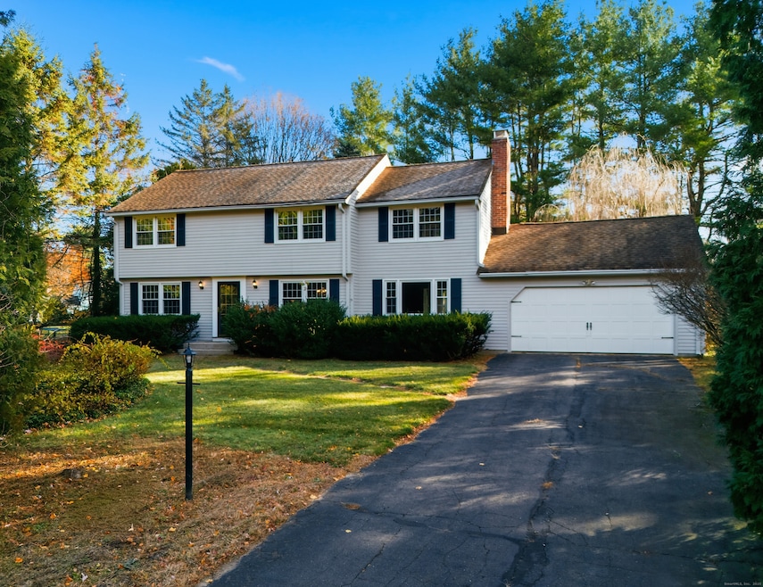
***Highest and Best - Friday 11/21 by 5 p.m.*** A Well-Maintained Colonial in Simsbury This classic 4-bedroom, 2.5-bath Colonial offers the perfect opportunity to move in now and make updates at your own pace. Situated in a highly convenient location near shopping, dining, and Simsbury's beloved Rails-to-Trails network, this home combines comfort, functionality, and long-term potential. Step inside to find hardwood floors throughout, a freshly painted exterior, and a sun porch ideal for enjoying all seasons. Major systems have been addressed over the years-including updates to the roof, windows, furnace, and electrical panel-giving you peace of mind. Public water and septic, and a recent septic inspection and repair has been completed, with a copy of the repair invoice available in the MLS documents section. Don't miss your chance to live in one of Simsbury's most accessible neighborhoods-close to trails, town amenities, and all that makes this community special.
Last Agent to Sell the Property
William Raveis Real Estate Brokerage Phone: (860) 983-4446 License #RES.0101145 Listed on: 11/10/2025
| Date | Type | Sale Price | Title Company |
|---|---|---|---|
| Executors Deed | $507,500 | -- |
| Date | Status | Loan Amount | Loan Type |
|---|---|---|---|
| Open | $376,875 | New Conventional |
| Date | Event | Price | List to Sale | Price per Sq Ft |
|---|---|---|---|---|
| 12/23/2025 12/23/25 | Sold | $507,500 | +26.9% | $238 / Sq Ft |
| 11/22/2025 11/22/25 | Pending | -- | -- | -- |
| 11/17/2025 11/17/25 | For Sale | $399,900 | -- | $188 / Sq Ft |
| Year | Tax Paid | Tax Assessment Tax Assessment Total Assessment is a certain percentage of the fair market value that is determined by local assessors to be the total taxable value of land and additions on the property. | Land | Improvement |
|---|---|---|---|---|
| 2025 | $8,838 | $258,720 | $80,500 | $178,220 |
| 2024 | $8,618 | $258,720 | $80,500 | $178,220 |
| 2023 | $8,232 | $258,720 | $80,500 | $178,220 |
| 2022 | $7,823 | $202,510 | $87,490 | $115,020 |
| 2021 | $7,823 | $202,510 | $87,490 | $115,020 |
| 2020 | $7,511 | $202,510 | $87,490 | $115,020 |
| 2019 | $7,558 | $202,510 | $87,490 | $115,020 |
| 2018 | $7,612 | $202,510 | $87,490 | $115,020 |
| 2017 | $7,123 | $183,770 | $83,560 | $100,210 |
| 2016 | $6,822 | $183,770 | $83,560 | $100,210 |
| 2015 | $6,822 | $183,770 | $83,560 | $100,210 |
| 2014 | $6,825 | $183,770 | $83,560 | $100,210 |
Seller's Agent in 2025
Geena Becker
William Raveis Real Estate
(860) 677-4661
23 in this area
138 Total Sales
Buyer's Agent in 2025
Ellen Seifts
Berkshire Hathaway Home Services
(860) 214-3540
23 in this area
212 Total Sales
Source: SmartMLS
MLS Number: 24139557
APN: SIMS-000005G-000302-000019
Disclaimer: Certain information contained herein is derived from information provided by parties other than Homes.com. All information provided is deemed reliable, but is not guaranteed to be accurate and should be independently verified.
![]() IDX information is provided exclusively for personal, non-commercial use, and may not be used for any purpose other than to identify prospective properties consumers may be interested in purchasing. Information is deemed reliable but not guaranteed.
IDX information is provided exclusively for personal, non-commercial use, and may not be used for any purpose other than to identify prospective properties consumers may be interested in purchasing. Information is deemed reliable but not guaranteed.
Ask me questions while you tour the home.