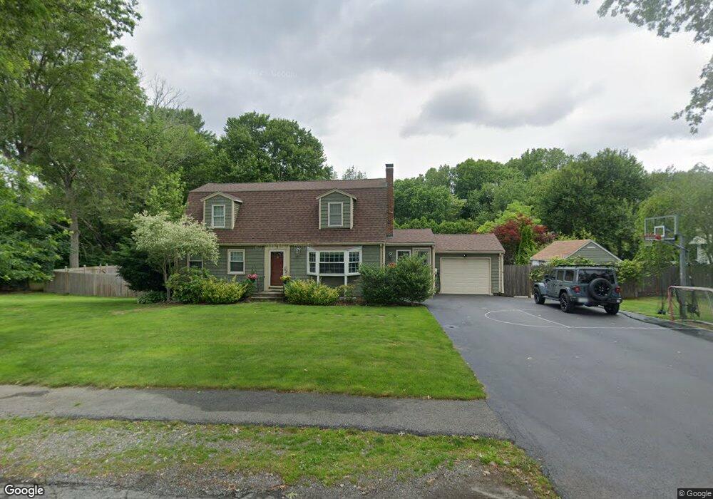
2 Plymouth Ln East Walpole, MA 02032
Estimated Value: $787,230 - $873,000
5
Beds
2
Baths
1,928
Sq Ft
$433/Sq Ft
Est. Value
About This Home
This home is located at 2 Plymouth Ln, East Walpole, MA 02032 and is currently estimated at $834,308, approximately $432 per square foot. 2 Plymouth Ln is a home located in Norfolk County with nearby schools including Old Post Road School, Walpole Middle School, and Walpole High School.
Ownership History
Date
Name
Owned For
Owner Type
Purchase Details
Closed on
Aug 15, 2005
Sold by
Dennett Cheri L and Dennett Edmund V
Bought by
Lessard Albert M and Lessard Natasha
Current Estimated Value
Home Financials for this Owner
Home Financials are based on the most recent Mortgage that was taken out on this home.
Original Mortgage
$350,000
Interest Rate
5.54%
Mortgage Type
Purchase Money Mortgage
Purchase Details
Closed on
Feb 28, 2002
Sold by
Bowes Janet H
Bought by
Dennett Edmund and Dennett Cheri L
Purchase Details
Closed on
Dec 15, 1989
Sold by
Reed William L
Bought by
Bowes Peter J
Create a Home Valuation Report for This Property
The Home Valuation Report is an in-depth analysis detailing your home's value as well as a comparison with similar homes in the area
Home Values in the Area
Average Home Value in this Area
Purchase History
| Date | Buyer | Sale Price | Title Company |
|---|---|---|---|
| Lessard Albert M | $515,000 | -- | |
| Dennett Edmund | $353,500 | -- | |
| Bowes Peter J | $190,000 | -- |
Source: Public Records
Mortgage History
| Date | Status | Borrower | Loan Amount |
|---|---|---|---|
| Open | Bowes Peter J | $312,400 | |
| Closed | Lessard Albert M | $350,000 | |
| Previous Owner | Bowes Peter J | $40,000 | |
| Previous Owner | Bowes Peter J | $30,000 |
Source: Public Records
Tax History Compared to Growth
Tax History
| Year | Tax Paid | Tax Assessment Tax Assessment Total Assessment is a certain percentage of the fair market value that is determined by local assessors to be the total taxable value of land and additions on the property. | Land | Improvement |
|---|---|---|---|---|
| 2025 | $8,671 | $675,800 | $335,000 | $340,800 |
| 2024 | $8,408 | $636,000 | $322,000 | $314,000 |
| 2023 | $8,070 | $581,000 | $280,100 | $300,900 |
| 2022 | $7,593 | $525,100 | $259,400 | $265,700 |
| 2021 | $7,441 | $501,400 | $244,700 | $256,700 |
| 2020 | $7,276 | $485,400 | $230,900 | $254,500 |
| 2019 | $6,985 | $462,600 | $222,000 | $240,600 |
| 2018 | $6,693 | $438,300 | $214,000 | $224,300 |
| 2017 | $6,503 | $424,200 | $205,700 | $218,500 |
| 2016 | $6,311 | $405,600 | $197,700 | $207,900 |
| 2015 | $6,131 | $390,500 | $188,300 | $202,200 |
| 2014 | $5,888 | $373,600 | $188,300 | $185,300 |
Source: Public Records
Map
Nearby Homes
- Unit 11 Powder House Ln Unit 11
- 8 Powder House Ln Unit 2
- Unit 12 Powder House Ln Unit 12
- Unit 3 Powder House Ln Unit 3
- 11 Park Ln
- 0 Charlotte Rd
- 7 Washington Green
- 93 Brewster Dr
- 363 - 367 Washington St
- 270 Moosehill Rd
- 486 Washington St
- 38 Cape Club Dr Unit 38
- 40 Cape Club Dr Unit 40
- 2 Alexandra Way
- 22 Coolidge Rd
- 256 Norwood St
- 1 Providence Hwy
- 34 Austin St Unit 1L
- 5 Atwood Ave
- 30 Bullard St