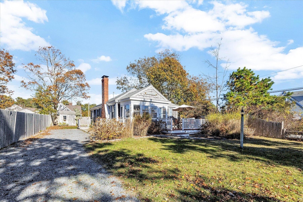
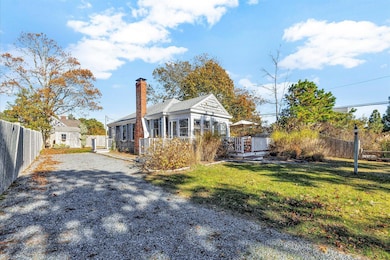
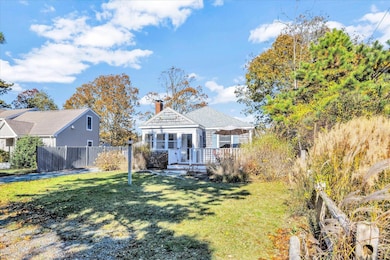
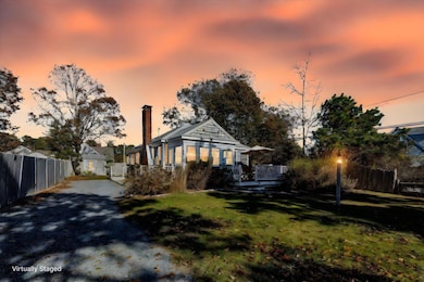
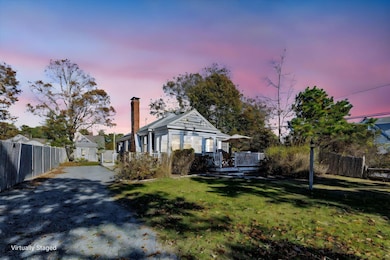
2 Rita Mary Way West Dennis, MA 2670
West Dennis NeighborhoodEstimated payment $3,948/month
Highlights
- Hot Property
- 1 Fireplace
- Bungalow
- Wood Flooring
- No HOA
- Outdoor Shower
About This Home
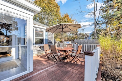
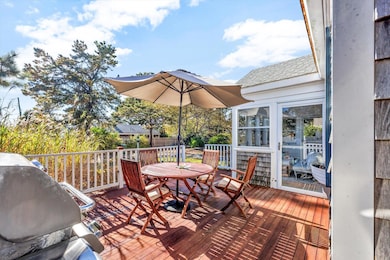
Charming Cape Cod Cottage in Coveted West Dennis Fingers NeighborhoodDiscover your perfect Cape Cod getaway. Nestled on a quiet, three-home dead-end street, this delightful cottage offers tranquility and exclusivity just a short stroll from the vibrant shores of West Dennis Beach and the charm of nearby Wrinkle Point.This property perfectly blends classic Cape Cod character with modern convenience, featuring warm pine paneling, oak hardwood floors, and rustic oak beam ceiling accents that create an inviting, cozy atmosphere.The home features a smart separation of space, with the three comfortable bedrooms located on the east side for quiet repose, and the kitchen/living area situated on the west side, flowing naturally into the sunroom and large deck.This is more than a cottage; it's a lifestyle opportunity. Whether you're looking for a peaceful year-round residence, a summer escape, or a savvy investment property, this charming home is a must-see.Schedule your private tour today and start living the Cape Cod dream!
Home Details
Home Type
- Single Family
Est. Annual Taxes
- $2,827
Year Built
- Built in 1943 | Remodeled
Lot Details
- 7,841 Sq Ft Lot
- Street terminates at a dead end
- Fenced
- Level Lot
Home Design
- Bungalow
- Block Foundation
- Shingle Roof
- Shingle Siding
Interior Spaces
- 768 Sq Ft Home
- 1-Story Property
- 1 Fireplace
- Crawl Space
- Gas Range
- Stacked Washer and Dryer
Flooring
- Wood
- Tile
Bedrooms and Bathrooms
- 3 Bedrooms
- 1 Full Bathroom
Pool
- Outdoor Shower
Utilities
- Central Air
- Heating Available
- Electric Water Heater
- Septic Tank
Community Details
- No Home Owners Association
Listing and Financial Details
- Assessor Parcel Number DENN M:000026 P:098000
Map
Home Values in the Area
Average Home Value in this Area
Tax History
| Year | Tax Paid | Tax Assessment Tax Assessment Total Assessment is a certain percentage of the fair market value that is determined by local assessors to be the total taxable value of land and additions on the property. | Land | Improvement |
|---|---|---|---|---|
| 2025 | $2,827 | $653,000 | $393,300 | $259,700 |
| 2024 | $2,375 | $540,900 | $315,200 | $225,700 |
| 2023 | $2,297 | $491,900 | $286,600 | $205,300 |
| 2022 | $2,304 | $411,400 | $258,100 | $153,300 |
| 2021 | $2,280 | $378,100 | $253,100 | $125,000 |
| 2020 | $2,408 | $394,700 | $281,200 | $113,500 |
| 2019 | $2,354 | $381,600 | $275,700 | $105,900 |
| 2018 | $2,275 | $358,800 | $262,400 | $96,400 |
| 2017 | $2,027 | $329,600 | $236,200 | $93,400 |
| 2016 | $2,098 | $321,300 | $241,400 | $79,900 |
| 2015 | $2,056 | $321,300 | $241,400 | $79,900 |
| 2014 | $2,040 | $321,300 | $241,400 | $79,900 |
Property History
| Date | Event | Price | List to Sale | Price per Sq Ft |
|---|---|---|---|---|
| 11/07/2025 11/07/25 | For Sale | $705,000 | -- | $918 / Sq Ft |
Purchase History
| Date | Type | Sale Price | Title Company |
|---|---|---|---|
| Deed | $305,000 | -- | |
| Deed | $126,000 | -- |
Mortgage History
| Date | Status | Loan Amount | Loan Type |
|---|---|---|---|
| Open | $244,000 | Purchase Money Mortgage | |
| Previous Owner | $124,250 | Purchase Money Mortgage |
Source: Cape Cod & Islands Association of REALTORS®
MLS Number: 22505547
APN: DENN-000026-000000-000098
Disclaimer: Certain information contained herein is derived from information provided by parties other than Homes.com. All information provided is deemed reliable, but is not guaranteed to be accurate and should be independently verified.
![]() All data relating to real estate for sale on this page comes from the Broker Reciprocity (BR) of the Cape Cod & Islands Multiple Listing Service, Inc. Detailed information about real estate listings held by brokerage firms other than CC&I Assoc. of REALTORS®, Inc. includes the name of the listing company. Neither the listing company nor CC&I Assoc. of REALTORS®, Inc. shall be responsible for any typographical errors, misinformation, misprints and shall be held totally harmless. The Broker providing this data believes it to be correct, but advises interested parties to confirm any item before relying on it in a purchase decision. All properties are subject to prior sale, changes, or withdrawal. Copyright 2025 © Cape Cod & Islands Multiple Listing Service, Inc. All rights reserved.
All data relating to real estate for sale on this page comes from the Broker Reciprocity (BR) of the Cape Cod & Islands Multiple Listing Service, Inc. Detailed information about real estate listings held by brokerage firms other than CC&I Assoc. of REALTORS®, Inc. includes the name of the listing company. Neither the listing company nor CC&I Assoc. of REALTORS®, Inc. shall be responsible for any typographical errors, misinformation, misprints and shall be held totally harmless. The Broker providing this data believes it to be correct, but advises interested parties to confirm any item before relying on it in a purchase decision. All properties are subject to prior sale, changes, or withdrawal. Copyright 2025 © Cape Cod & Islands Multiple Listing Service, Inc. All rights reserved.
- 14 Schoolhouse Ln
- 209 Main St Unit 3
- 209 Main St Unit 6
- 209 Main St Unit 1
- 209 Main St Unit 2
- 209 Main St Unit 4
- 209 Main St Unit 5
- 178 School St
- 308 Old Main St
- 181 Pleasant St
- 23 Doric Ave
- 45 Seth Ln
- 40 Kelley Rd
- 401 Main St Unit 201
- 401 Main St Unit 101
- 29 Bass River Rd
- 22 Powhatan Rd
- 745 Willow St
- 18 Turner Ln
- 467 Main St
- 6 Lauries Ln
- 12 Town Hall Ave
- 51 Ocean Ave Unit 103
- 26 Lone Tree Rd Unit A
- 173 Captain Chase Rd Unit A
- 173 Captain Chase Rd Unit B
- 70 Poinsettia Dr
- 28 Swan Lake Rd
- 166 Seaview Ave Unit 2a
- 45 Bernard St
- 56 Center St Unit 2-3
- 451 Main St Unit 2
- 80 Mattakese Rd Unit 7
- 110 Depot St
- 576 Main St Unit 3
- 483 Route 28
- 4 Summer St
- 141 Division St Unit 4
- 5 Elwood Rd
- 20 Trumet Rd
