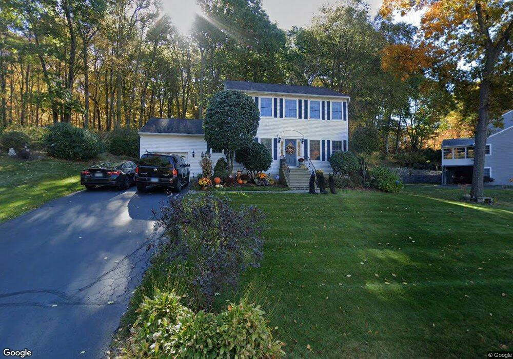
2 S Colman Rd Wolcott, CT 06716
Estimated Value: $503,896 - $537,000
3
Beds
3
Baths
1,932
Sq Ft
$267/Sq Ft
Est. Value
About This Home
This home is located at 2 S Colman Rd, Wolcott, CT 06716 and is currently estimated at $514,974, approximately $266 per square foot. 2 S Colman Rd is a home located in New Haven County with nearby schools including Tyrrell Middle School, Wolcott High School, and St Peter & Paul School.
Ownership History
Date
Name
Owned For
Owner Type
Purchase Details
Closed on
Oct 16, 2002
Sold by
Lepage Steven K and Lepage Denise M
Bought by
Dreher David P and Dreher Elaine A
Current Estimated Value
Purchase Details
Closed on
Nov 19, 1999
Sold by
Gaudiosi Douglas A
Bought by
Lepage Steven K and Lepage Denise M
Purchase Details
Closed on
Mar 22, 1996
Sold by
Wolcott Associates
Bought by
Gaudiosi Douglas A and Gaudiosi Marsha O
Create a Home Valuation Report for This Property
The Home Valuation Report is an in-depth analysis detailing your home's value as well as a comparison with similar homes in the area
Home Values in the Area
Average Home Value in this Area
Purchase History
| Date | Buyer | Sale Price | Title Company |
|---|---|---|---|
| Dreher David P | $260,000 | -- | |
| Lepage Steven K | $176,000 | -- | |
| Gaudiosi Douglas A | $164,000 | -- |
Source: Public Records
Mortgage History
| Date | Status | Borrower | Loan Amount |
|---|---|---|---|
| Open | Gaudiosi Douglas A | $84,000 | |
| Closed | Gaudiosi Douglas A | $38,800 | |
| Closed | Gaudiosi Douglas A | $66,600 |
Source: Public Records
Tax History Compared to Growth
Tax History
| Year | Tax Paid | Tax Assessment Tax Assessment Total Assessment is a certain percentage of the fair market value that is determined by local assessors to be the total taxable value of land and additions on the property. | Land | Improvement |
|---|---|---|---|---|
| 2025 | $8,564 | $238,350 | $62,800 | $175,550 |
| 2024 | $7,882 | $238,350 | $62,800 | $175,550 |
| 2023 | $7,596 | $238,350 | $62,800 | $175,550 |
| 2022 | $7,341 | $238,350 | $62,800 | $175,550 |
| 2021 | $7,063 | $213,120 | $59,450 | $153,670 |
| 2020 | $7,063 | $213,120 | $59,450 | $153,670 |
| 2019 | $7,063 | $213,120 | $59,450 | $153,670 |
| 2018 | $6,862 | $213,120 | $59,450 | $153,670 |
| 2017 | $6,664 | $213,120 | $59,450 | $153,670 |
| 2016 | $6,471 | $223,820 | $60,390 | $163,430 |
| 2015 | $6,285 | $223,820 | $60,390 | $163,430 |
| 2014 | $6,081 | $223,820 | $60,390 | $163,430 |
Source: Public Records
Map
Nearby Homes
- 77 S Colman Rd
- 2 Old Farms Rd
- 1209 Woodtick Rd
- 00 Woodtick Rd
- 0 Woodtick Rd Unit 24119429
- 0 Bound Line Rd Unit 170253486
- 44 Knollwood Dr
- 0 Central Avenue and Old Bound Line Rd
- 59 Forest Ln
- 124 East St
- 87 Ransom Hall Rd
- 2 Andrea Ave
- 47 Finch Rd
- 143 Bound Line Rd
- 13 Margaret Terrace
- 20 Wolf Hill Rd Unit 4D
- 20 Wolf Hill Rd Unit 6F
- 0 Coe Rd
- 73 Chesterfield Ave
- 3 Pimlico Rd
- 19 Old New England Rd
- 1 S Colman Rd
- 15 Old New England Rd
- 18 Old New England Rd
- 23 Old New England Rd
- 14 Old New England Rd
- 10 Old New England Rd
- 9 Old New England Rd
- 27 Old New England Rd
- 8 S Colman Rd
- 22 Old New England Rd
- 26 Old New England Rd
- 6 Old New England Rd
- 11 S Colman Rd
- 5 Old New England Rd
- 31 Old New England Rd
- 5 Ledgebrook Dr
- 30 Old New England Rd
- 159 Old Bound Line Rd
- 3 Ledgebrook Dr