
Seller's Agent in 2017
Sharon Pelletier
Hope Real Estate Group, Inc.
(508) 954-7222
39 in this area
50 Total Sales


Estimated Value: $647,000 - $2,713,000
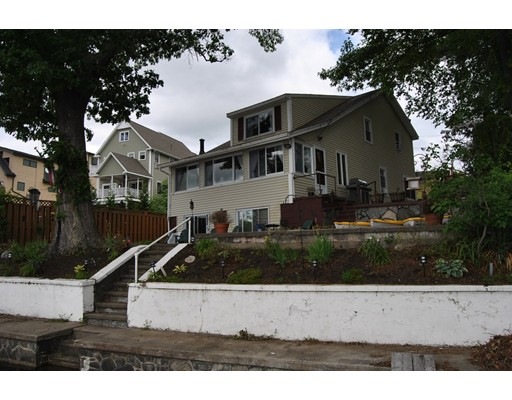
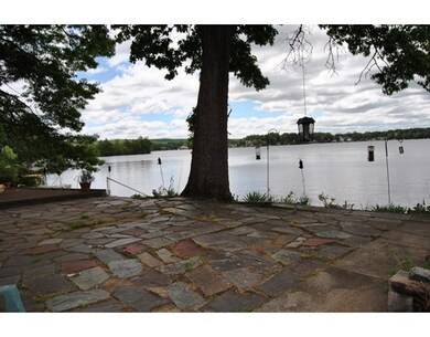
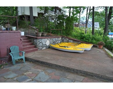
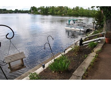
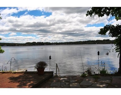
PANORAMIC VIEWS OF WEBSTER LAKE! Great South Facing Location, 62' prime lakefront, large deep lot 10,489sf (.24 ac), flagstone & concrete patios, full concrete walkway at water's edge, dock, retaining walls & stonework, privacy fence, storage shed, recently paved drive, plenty offstreet parking in driveway & area at roadside, spacious, Year-round, 2 story Cape home, 4 BRs (1 on 1st flr), 2 full BAs, Harvey replacement windows, 6 year+/- young roof.
Home Type
Single Family
Year Built
1937
Lot Details
10,454 Sq Ft Lot
| Date | Buyer | Sale Price | Title Company |
|---|---|---|---|
| Brigham Ronald R | $415,000 | -- | |
| Holyoke Jeffrey | $400,000 | -- |
| Date | Status | Borrower | Loan Amount |
|---|---|---|---|
| Open | Brigham Ronald R | $391,110 | |
| Previous Owner | Holyoke Jeffrey | $340,000 |
| Date | Event | Price | List to Sale | Price per Sq Ft | Prior Sale |
|---|---|---|---|---|---|
| 12/15/2017 12/15/17 | Sold | $415,000 | -1.2% | $243 / Sq Ft | |
| 09/14/2017 09/14/17 | Pending | -- | -- | -- | |
| 08/04/2017 08/04/17 | Price Changed | $419,900 | 0.0% | $246 / Sq Ft | |
| 08/04/2017 08/04/17 | For Sale | $419,900 | -4.6% | $246 / Sq Ft | |
| 02/19/2017 02/19/17 | For Sale | $440,000 | +10.0% | $257 / Sq Ft | |
| 11/28/2014 11/28/14 | Sold | $400,000 | -0.6% | $234 / Sq Ft | View Prior Sale |
| 11/28/2014 11/28/14 | Pending | -- | -- | -- | |
| 11/25/2014 11/25/14 | For Sale | $402,594 | -- | $235 / Sq Ft |
| Year | Tax Paid | Tax Assessment Tax Assessment Total Assessment is a certain percentage of the fair market value that is determined by local assessors to be the total taxable value of land and additions on the property. | Land | Improvement |
|---|---|---|---|---|
| 2025 | $8,301 | $698,700 | $444,600 | $254,100 |
| 2024 | $7,690 | $631,400 | $386,900 | $244,500 |
| 2023 | $7,194 | $575,500 | $368,300 | $207,200 |
| 2022 | $6,895 | $493,900 | $327,600 | $166,300 |
| 2021 | $7,126 | $471,900 | $327,600 | $144,300 |
| 2020 | $7,006 | $465,200 | $327,600 | $137,600 |
| 2019 | $6,946 | $453,100 | $327,600 | $125,500 |
| 2018 | $6,836 | $444,200 | $327,600 | $116,600 |
| 2017 | $6,740 | $445,500 | $331,900 | $113,600 |
| 2016 | $5,980 | $395,000 | $285,800 | $109,200 |
| 2015 | $5,687 | $387,400 | $280,200 | $107,200 |
Seller's Agent in 2017
Sharon Pelletier
Hope Real Estate Group, Inc.
(508) 954-7222
39 in this area
50 Total Sales
Buyer's Agent in 2017
Gary Powell
The Neighborhood Realty Group
(774) 242-7034
8 Total Sales
M
Seller's Agent in 2014
Matthew Ross
Hope Real Estate Group, Inc.
(774) 535-4285
1 Total Sale
Source: MLS Property Information Network (MLS PIN)
MLS Number: 72120587
APN: WEBS-000046-A000000-000039
Disclaimer: Certain information contained herein is derived from information provided by parties other than Homes.com. All information provided is deemed reliable, but is not guaranteed to be accurate and should be independently verified.
![]() The property listing data and information, or the Images, set forth herein were provided to MLS Property Information Network, Inc. from third party sources, including sellers, lessors and public records, and were compiled by MLS Property Information Network, Inc. The property listing data and information, and the Images, are for the personal, non-commercial use of consumers having a good faith interest in purchasing or leasing listed properties of the type displayed to them and may not be used for any purpose other than to identify prospective properties which such consumers may have a good faith interest in purchasing or leasing. MLS Property Information Network, Inc. and its subscribers disclaim any and all representations and warranties as to the accuracy of the property listing data and information, or as to the accuracy of any of the Images, set forth herein.
The property listing data and information, or the Images, set forth herein were provided to MLS Property Information Network, Inc. from third party sources, including sellers, lessors and public records, and were compiled by MLS Property Information Network, Inc. The property listing data and information, and the Images, are for the personal, non-commercial use of consumers having a good faith interest in purchasing or leasing listed properties of the type displayed to them and may not be used for any purpose other than to identify prospective properties which such consumers may have a good faith interest in purchasing or leasing. MLS Property Information Network, Inc. and its subscribers disclaim any and all representations and warranties as to the accuracy of the property listing data and information, or as to the accuracy of any of the Images, set forth herein.
Ask me questions while you tour the home.