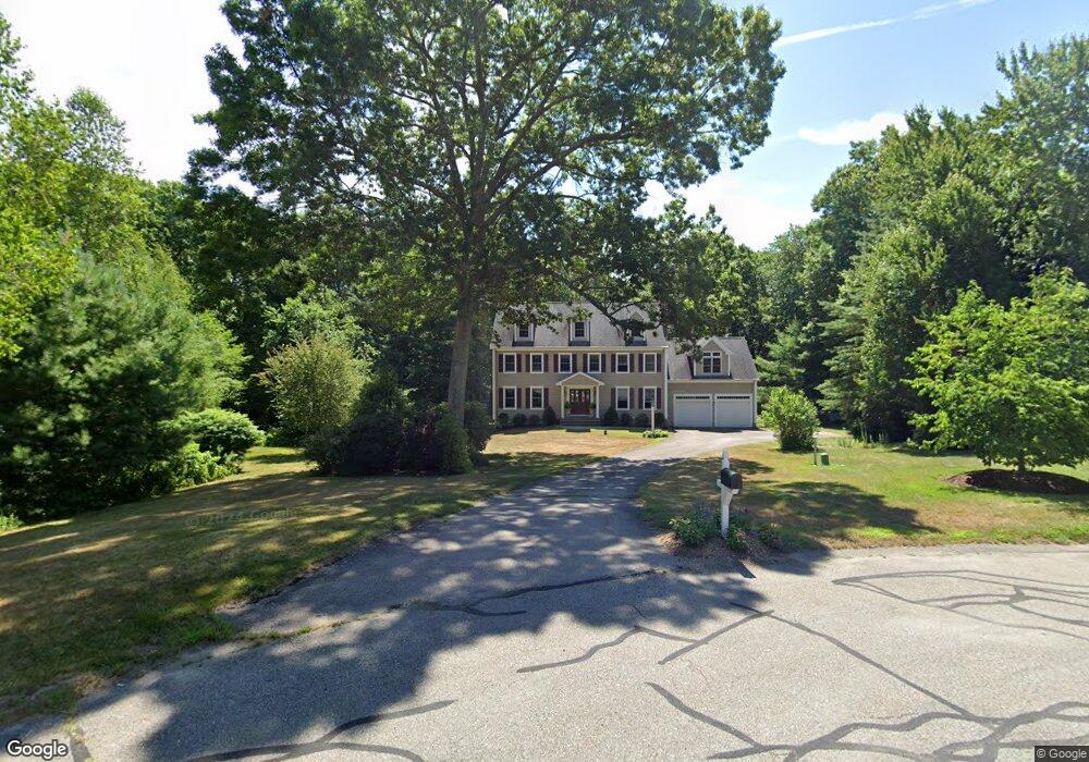
2 Stable Way Medway, MA 02053
Estimated Value: $945,896 - $1,159,000
4
Beds
3
Baths
2,882
Sq Ft
$365/Sq Ft
Est. Value
About This Home
This home is located at 2 Stable Way, Medway, MA 02053 and is currently estimated at $1,052,224, approximately $365 per square foot. 2 Stable Way is a home located in Norfolk County with nearby schools including John D. McGovern Elementary School, Burke-Memorial Elementary, and Medway Middle School.
Ownership History
Date
Name
Owned For
Owner Type
Purchase Details
Closed on
May 9, 2001
Sold by
Dempsey Thomas
Bought by
Rider James S and Rider Michelle B
Current Estimated Value
Home Financials for this Owner
Home Financials are based on the most recent Mortgage that was taken out on this home.
Original Mortgage
$275,000
Interest Rate
6.88%
Mortgage Type
Purchase Money Mortgage
Purchase Details
Closed on
Dec 22, 1999
Sold by
Aicardi Tr Tim
Bought by
Dempsey Thomas
Home Financials for this Owner
Home Financials are based on the most recent Mortgage that was taken out on this home.
Original Mortgage
$327,900
Interest Rate
7.61%
Mortgage Type
Purchase Money Mortgage
Create a Home Valuation Report for This Property
The Home Valuation Report is an in-depth analysis detailing your home's value as well as a comparison with similar homes in the area
Home Values in the Area
Average Home Value in this Area
Purchase History
| Date | Buyer | Sale Price | Title Company |
|---|---|---|---|
| Rider James S | $490,000 | -- | |
| Dempsey Thomas | $409,900 | -- |
Source: Public Records
Mortgage History
| Date | Status | Borrower | Loan Amount |
|---|---|---|---|
| Open | Dempsey Thomas | $300,000 | |
| Closed | Dempsey Thomas | $275,000 | |
| Previous Owner | Dempsey Thomas | $327,900 |
Source: Public Records
Tax History Compared to Growth
Tax History
| Year | Tax Paid | Tax Assessment Tax Assessment Total Assessment is a certain percentage of the fair market value that is determined by local assessors to be the total taxable value of land and additions on the property. | Land | Improvement |
|---|---|---|---|---|
| 2025 | $12,168 | $853,900 | $377,100 | $476,800 |
| 2024 | $12,296 | $853,900 | $377,100 | $476,800 |
| 2023 | $11,332 | $710,900 | $316,100 | $394,800 |
| 2022 | $10,464 | $618,100 | $233,400 | $384,700 |
| 2021 | $10,616 | $608,000 | $222,500 | $385,500 |
| 2020 | $10,528 | $601,600 | $224,700 | $376,900 |
| 2019 | $10,085 | $594,300 | $220,300 | $374,000 |
| 2018 | $10,386 | $588,100 | $220,300 | $367,800 |
| 2017 | $9,903 | $552,600 | $209,400 | $343,200 |
| 2016 | $10,127 | $559,200 | $220,300 | $338,900 |
| 2015 | $10,094 | $553,400 | $220,300 | $333,100 |
| 2014 | $10,134 | $537,900 | $220,600 | $317,300 |
Source: Public Records
Map
Nearby Homes
- 15 Broad Acres Farm Rd
- 12 Longmeadow Ln
- 116 Winthrop St
- 56 Paul Rd
- 78 Fisher St
- 4 Deerfield Rd
- 85 Fisher St
- 19 Sycamore Way Unit L40
- 7 Hill St
- 6 Freedom Trail
- 14 Heritage Dr
- 176 Main St Unit 3
- 6 Rainbow Dr
- 5 Fales St
- 36 Lovering St
- 220 Main St Unit 220
- 0 Hill St
- 39 West St
- 28 Wellington St
- 22 Sunset Dr
- 1 Stable Way
- 12 Broad Acres Farm Rd
- 3 Stable Way
- 10 Broad Acres Farm Rd
- 4 Stable Way
- 14 Broad Acres Farm Rd
- 7 Claybrook Farm Rd
- 135 Summer St
- 135-a Summer St
- 135A Summer St
- 5 Stable Way
- 17 Olde Surrey Ln
- 8 Broad Acres Farm Rd
- 11 Broad Acres Farm Rd
- 7 Stable Way
- 9 Claybrook Farm Rd
- 13 Broad Acres Farm Rd
- 9 Broad Acres Farm Rd
- 18 Broad Acres Farm Rd
- 15 Olde Surrey Ln