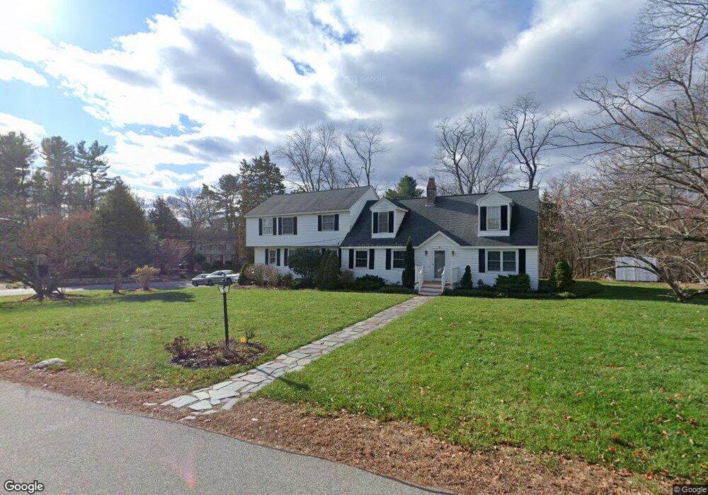
2 Sunnyside Ln Lincoln, MA 01773
Estimated Value: $1,325,000 - $1,534,000
4
Beds
4
Baths
3,221
Sq Ft
$433/Sq Ft
Est. Value
About This Home
This home is located at 2 Sunnyside Ln, Lincoln, MA 01773 and is currently estimated at $1,394,089, approximately $432 per square foot. 2 Sunnyside Ln is a home located in Middlesex County with nearby schools including Lincoln-Sudbury Regional High School, Tremont School, and Concord Academy.
Ownership History
Date
Name
Owned For
Owner Type
Purchase Details
Closed on
Oct 4, 1994
Sold by
Hsiao Chia Chuan and Wang Haw Ying
Bought by
Tam Edwin P and Tam Karen Y
Current Estimated Value
Purchase Details
Closed on
Feb 28, 1989
Sold by
Briggs Ronald J
Bought by
Hsiao Chia Chuan
Create a Home Valuation Report for This Property
The Home Valuation Report is an in-depth analysis detailing your home's value as well as a comparison with similar homes in the area
Home Values in the Area
Average Home Value in this Area
Purchase History
| Date | Buyer | Sale Price | Title Company |
|---|---|---|---|
| Tam Edwin P | $270,000 | -- | |
| Hsiao Chia Chuan | $330,000 | -- |
Source: Public Records
Mortgage History
| Date | Status | Borrower | Loan Amount |
|---|---|---|---|
| Open | Hsiao Chia Chuan | $379,000 | |
| Closed | Hsiao Chia Chuan | $384,500 | |
| Closed | Hsiao Chia Chuan | $390,000 |
Source: Public Records
Tax History Compared to Growth
Tax History
| Year | Tax Paid | Tax Assessment Tax Assessment Total Assessment is a certain percentage of the fair market value that is determined by local assessors to be the total taxable value of land and additions on the property. | Land | Improvement |
|---|---|---|---|---|
| 2025 | $131 | $1,021,500 | $664,200 | $357,300 |
| 2024 | $12,912 | $1,001,700 | $651,200 | $350,500 |
| 2023 | $13,196 | $948,000 | $599,800 | $348,200 |
| 2022 | $12,847 | $860,500 | $542,200 | $318,300 |
| 2021 | $12,030 | $775,100 | $479,800 | $295,300 |
| 2020 | $11,611 | $755,900 | $479,800 | $276,100 |
| 2019 | $10,461 | $745,600 | $464,700 | $280,900 |
| 2018 | $10,140 | $745,600 | $464,700 | $280,900 |
| 2017 | $9,694 | $707,600 | $438,700 | $268,900 |
| 2016 | $9,650 | $689,800 | $425,700 | $264,100 |
| 2015 | $9,178 | $648,600 | $394,100 | $254,500 |
| 2014 | $8,719 | $605,100 | $353,000 | $252,100 |
Source: Public Records
Map
Nearby Homes
- 16 Old Cambridge Turnpike
- 22 Old Cambridge Turnpike
- 29 S Commons Unit D
- 5 South Commons Unit D
- 36 Indian Camp Ln Unit D
- 241 Shadyside Ave
- 646 Cambridge Turnpike
- 9 Garland Rd
- 10 Reiling Pond Rd
- 84 Davison Dr
- 22 Lincoln Rd
- 69 Page Rd
- 60 Baker Bridge Rd
- 16 Hatch Farm Ln
- 10 Hatch Farm Ln
- 28 Hatch Farm Ln
- 44 Baker Bridge Rd
- 96 Independence Rd
- 8 Stratford Way
- 140 Revolutionary Rd
- 31 Morningside Ln
- 38 Morningside Ln
- 39 Morningside Ln
- 34 Morningside Ln
- 8 Sunnyside Ln
- 40 Morningside Ln
- 7 Sunnyside Ln
- 30 Morningside Ln
- 30 Morningside Ln
- 41 Morningside Ln
- 27 Morningside Ln
- 26 Morningside Ln
- 26 Morningside Ln Unit 1
- 11 Sunnyside Ln
- 25 Morningside Ln
- 20 Morningside Ln
- 23 Morningside Ln
- 10 Brooks Hill Rd
- 16 Sunnyside Ln
- 8 Brooks Hill Rd