


2 Swan Lake Ave Belfast, ME 04915
Estimated payment $5,732/month
Highlights
- Scenic Views
- Property is near public transit
- No HOA
- 2.5 Acre Lot
- Corner Lot
About This Lot
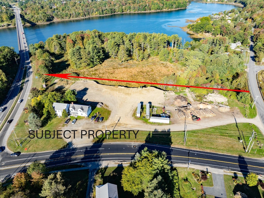
Developers and Investors take note this property is in a Prime Location! It's located on a Corner lot on Route 1 and Route 141, zoning allows many uses with planning board review. This is a combination of 2 lots, there is 3 phase power & Public sewer available, public water is already connected. The most recent average weekly traffic count is 22,695. The building on the property could be converted or removed. Possible owner financing if qualified. Just minutes to downtown Belfast. Call for an appointment.

Property Details
Property Type
- Land
Est. Annual Taxes
- $6,325
Lot Details
- 2.5 Acre Lot
- Corner Lot
- Level Lot
- Open Lot
- Property is zoned Rt141-MLComm
Parking
- Gravel Driveway
- On-Site Parking
Utilities
- Natural Gas Not Available
- Septic Tank
- Private Sewer
Additional Features
- Scenic Vista Views
- Property is near public transit
- Mobile Home Allowed
Community Details
- No Home Owners Association
Listing and Financial Details
- Tax Lot 14
- Assessor Parcel Number BELF-000019-000000-000014
Map
Home Values in the Area
Average Home Value in this Area
Tax History
| Year | Tax Paid | Tax Assessment Tax Assessment Total Assessment is a certain percentage of the fair market value that is determined by local assessors to be the total taxable value of land and additions on the property. | Land | Improvement |
|---|---|---|---|---|
| 2024 | $5,093 | $330,700 | $73,000 | $257,700 |
| 2023 | $4,267 | $212,300 | $20,000 | $192,300 |
| 2022 | $4,385 | $204,900 | $20,000 | $184,900 |
| 2021 | $4,508 | $204,900 | $20,000 | $184,900 |
| 2020 | $4,555 | $195,500 | $20,000 | $175,500 |
| 2019 | $4,477 | $195,500 | $20,000 | $175,500 |
| 2018 | $4,438 | $195,500 | $20,000 | $175,500 |
| 2017 | $4,281 | $195,500 | $20,000 | $175,500 |
| 2016 | $4,477 | $195,500 | $20,000 | $175,500 |
| 2015 | $4,379 | $195,500 | $20,000 | $175,500 |
| 2014 | $4,116 | $190,100 | $20,000 | $170,100 |
| 2013 | $4,123 | $198,200 | $28,100 | $170,100 |
Property History
| Date | Event | Price | List to Sale | Price per Sq Ft |
|---|---|---|---|---|
| 09/25/2025 09/25/25 | For Sale | $989,500 | -- | -- |
Purchase History
| Date | Type | Sale Price | Title Company |
|---|---|---|---|
| Interfamily Deed Transfer | -- | -- |
Source: Maine Listings
MLS Number: 1638903
APN: BELF-000019-000000-000014
Disclaimer: Certain information contained herein is derived from information provided by parties other than Homes.com. All information provided is deemed reliable, but is not guaranteed to be accurate and should be independently verified.
![]() Listing data is derived in whole or in part from Maine Real Estate Information System, Inc. (d/b/a Maine Listings) and is for consumers' personal, noncommercial use only. Dimensions are approximate and not guaranteed. All data should be independently verified.
Listing data is derived in whole or in part from Maine Real Estate Information System, Inc. (d/b/a Maine Listings) and is for consumers' personal, noncommercial use only. Dimensions are approximate and not guaranteed. All data should be independently verified.
© 2025 Maine Real Estate Information System, Inc. All Rights Reserved. Equal Housing Opportunity.
Homes.com, LLC, 17600 Laguna Canyon Rd Irvine, CA 92618 (888)-952-6393
![]()
- 17 Footbridge Rd
- 6 Daniel Dr
- 12 Ashley Dr
- 37 Jacobs Rd
- 40 Robbins Rd
- 51 Bridge St
- 45 Brooke Ave
- 1 Miller St
- 208 High St
- 38 Spring St
- 73 Swan Lake Ave
- 28 Charles St
- 38 Union St
- 159 Waldo Ave
- 388 High St
- 90 Searsport Ave
- 225 Waldo Ave
- 0 Patterson Hill Rd Unit Lot 2 1614981
- 0 Robbins Rd Unit 1634953
- 68 Park St
- 60 Doak Rd
- 1 Addys Way Unit 1
- 21 Knox Bros Ave
- 144 Upper Bluff Rd Unit A
- 119 Main St Unit A
- 103 US Route 1 Unit 3upstairsunit
- 3 Cushing St Unit 2
- 1 Norwood Ave Unit B
- 114 Lebanon Rd Unit 14
- 104 Main St Unit 3
- 1458 N Main St
- 1 Pine Grove Dr
- 2213 Western Ave Unit C
- 851 Western Ave Unit Apartment 1
- 8 Sand Beach Ln
- 10 Sand Beach Ln
- 24 Oakwood Ln
- 32 Emerson Mill Rd Unit 6
- 32 Emerson Mill Rd Unit 5
- 198 Main Rd N Unit B