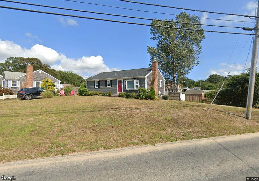
2 The Other Rd Dennis Port, MA 02639
Dennis Port NeighborhoodEstimated Value: $524,000 - $572,668
3
Beds
1
Bath
800
Sq Ft
$679/Sq Ft
Est. Value
About This Home
This home is located at 2 The Other Rd, Dennis Port, MA 02639 and is currently estimated at $543,417, approximately $679 per square foot. 2 The Other Rd is a home located in Barnstable County with nearby schools including Dennis-Yarmouth Regional High School and St. Pius X. School.
Ownership History
Date
Name
Owned For
Owner Type
Purchase Details
Closed on
Oct 15, 2004
Sold by
Brennan Kathleen M and Brennan Kathleen
Bought by
Rose Gregory N and Rose Marcia E
Current Estimated Value
Home Financials for this Owner
Home Financials are based on the most recent Mortgage that was taken out on this home.
Original Mortgage
$205,000
Outstanding Balance
$101,730
Interest Rate
5.8%
Mortgage Type
Purchase Money Mortgage
Estimated Equity
$441,687
Purchase Details
Closed on
Nov 26, 1996
Sold by
Via George C and Via Jean A
Bought by
Brennan Walter G
Create a Home Valuation Report for This Property
The Home Valuation Report is an in-depth analysis detailing your home's value as well as a comparison with similar homes in the area
Home Values in the Area
Average Home Value in this Area
Purchase History
| Date | Buyer | Sale Price | Title Company |
|---|---|---|---|
| Rose Gregory N | $257,500 | -- | |
| Brennan Walter G | $87,000 | -- |
Source: Public Records
Mortgage History
| Date | Status | Borrower | Loan Amount |
|---|---|---|---|
| Open | Rose Gregory N | $205,000 |
Source: Public Records
Tax History Compared to Growth
Tax History
| Year | Tax Paid | Tax Assessment Tax Assessment Total Assessment is a certain percentage of the fair market value that is determined by local assessors to be the total taxable value of land and additions on the property. | Land | Improvement |
|---|---|---|---|---|
| 2025 | $2,254 | $520,500 | $187,800 | $332,700 |
| 2024 | $2,101 | $478,600 | $180,600 | $298,000 |
| 2023 | $2,032 | $435,100 | $164,200 | $270,900 |
| 2022 | $1,953 | $348,800 | $147,900 | $200,900 |
| 2021 | $1,871 | $310,200 | $145,000 | $165,200 |
| 2020 | $1,707 | $279,800 | $133,800 | $146,000 |
| 2019 | $1,610 | $260,900 | $131,200 | $129,700 |
| 2018 | $1,605 | $253,200 | $135,300 | $117,900 |
| 2017 | $1,470 | $239,000 | $124,900 | $114,100 |
| 2016 | $1,478 | $226,400 | $130,100 | $96,300 |
| 2015 | $1,441 | $225,200 | $130,100 | $95,100 |
| 2014 | $1,331 | $209,600 | $114,500 | $95,100 |
Source: Public Records
Map
Nearby Homes
- 4 Coffey Ln
- 19 Standish Way
- 125 Main St Unit 3
- 71 Main St
- 22 Wixon Rd
- 72 Bassett Ln
- 268 Main St
- 31 Easy St
- 12 Spoonbill Rd
- 80 Michaels Ave
- 95 Center St
- 15 Woodside Park Rd
- 78 Upper County Rd Unit A&B
- 78 Upper County Rd
- 12 Candlewood Ln Unit 2-9
- 26 Center St
- 24 Indian Trail
- 20 Aunt Debbys Rd
- 166 Upper County Rd Unit 1-4
- 22 Ferncliff Rd