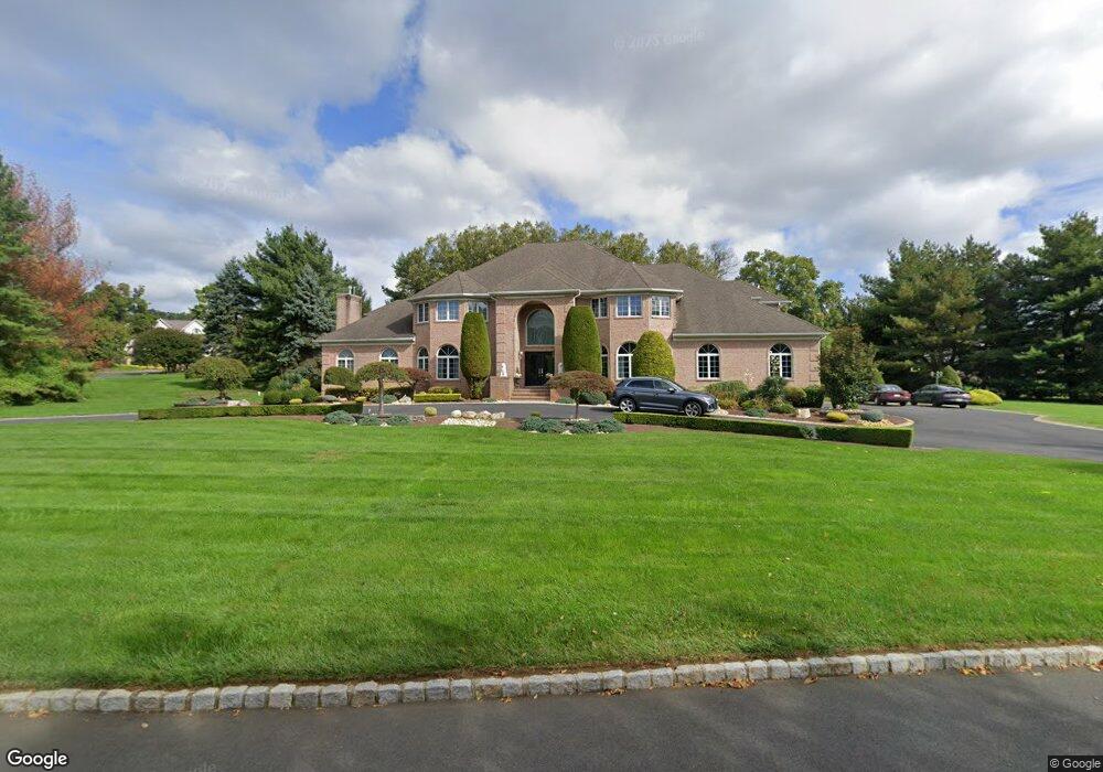
2 Tollhouse Ln Colts Neck, NJ 07722
Estimated Value: $1,938,000 - $2,189,000
4
Beds
6
Baths
5,471
Sq Ft
$378/Sq Ft
Est. Value
About This Home
This home is located at 2 Tollhouse Ln, Colts Neck, NJ 07722 and is currently estimated at $2,068,981, approximately $378 per square foot. 2 Tollhouse Ln is a home located in Monmouth County with nearby schools including Conover Road School, Cedar Drive Middle School, and Colts Neck High School.
Ownership History
Date
Name
Owned For
Owner Type
Purchase Details
Closed on
Dec 23, 2021
Sold by
Kapur and Manjou
Bought by
Kapur Manjou
Current Estimated Value
Home Financials for this Owner
Home Financials are based on the most recent Mortgage that was taken out on this home.
Original Mortgage
$980,000
Outstanding Balance
$900,616
Interest Rate
3.05%
Mortgage Type
New Conventional
Estimated Equity
$1,168,365
Purchase Details
Closed on
Nov 4, 1995
Sold by
Gatto Design & Dev Corp
Bought by
Kapur Arun and Kapur Manjou
Create a Home Valuation Report for This Property
The Home Valuation Report is an in-depth analysis detailing your home's value as well as a comparison with similar homes in the area
Home Values in the Area
Average Home Value in this Area
Purchase History
| Date | Buyer | Sale Price | Title Company |
|---|---|---|---|
| Kapur Manjou | $1,400,000 | Woodend Gary F | |
| Kapur Manjou | $1,400,000 | None Listed On Document | |
| Kapur Arun | $190,000 | -- |
Source: Public Records
Mortgage History
| Date | Status | Borrower | Loan Amount |
|---|---|---|---|
| Open | Kapur Manjou | $980,000 | |
| Closed | Kapur Manjou | $980,000 |
Source: Public Records
Tax History Compared to Growth
Tax History
| Year | Tax Paid | Tax Assessment Tax Assessment Total Assessment is a certain percentage of the fair market value that is determined by local assessors to be the total taxable value of land and additions on the property. | Land | Improvement |
|---|---|---|---|---|
| 2025 | $25,080 | $1,773,200 | $503,300 | $1,269,900 |
| 2024 | $23,995 | $1,683,200 | $490,500 | $1,192,700 |
| 2023 | $23,995 | $1,542,100 | $414,600 | $1,127,500 |
| 2022 | $23,255 | $1,404,900 | $354,600 | $1,050,300 |
| 2021 | $23,255 | $1,331,900 | $348,300 | $983,600 |
| 2020 | $22,874 | $1,296,700 | $348,300 | $948,400 |
| 2019 | $22,838 | $1,296,900 | $348,300 | $948,600 |
| 2018 | $23,123 | $1,302,700 | $354,300 | $948,400 |
| 2017 | $23,038 | $1,302,300 | $354,300 | $948,000 |
| 2016 | $22,794 | $1,316,800 | $353,300 | $963,500 |
| 2015 | $22,786 | $1,313,300 | $363,500 | $949,800 |
| 2014 | $21,042 | $1,247,300 | $488,500 | $758,800 |
Source: Public Records
Map
Nearby Homes
- 39 Mountainside Dr
- 88 Clover Hill Rd
- 20 Squire Terrace
- 12 Crest Dr
- 5 Pleasant Valley Rd
- 2 Warrenton Ln
- 1158 State Route 34
- 1 Embry Farm Rd
- 806 Turquoise Trail
- 11 Applethorn Ct
- 20 Birch Ln
- 9 Mulberry Ln
- 3 Wildhedge Ln
- 4 Gaitway Dr
- 220 Peacock Ln
- 0 Boundary Rd Unit 22520658
- 8 Tiberon Dr
- 10 Hop Brook Ln
- 18 Egret Ln
- 14 Saratoga Ct
- 4 Tanglewood Ct
- 3 Tollhouse Ln
- 1 Tollhouse Ln
- 51 Mountainside Dr
- 5 Tanglewood Ct
- 8 Tanglewood Ct
- 47 Mountainside Dr
- 3 Tanglewood Ct
- 7 Tanglewood Ct
- 62 Mountainside Dr
- 1 Tanglewood Ct
- 196 Newman Springs Rd
- 58 Mountainside Dr
- 9 Tanglewood Ct
- 43 Mountainside Dr
- 19 Mountainside Dr
- 15 Mountainside Dr
- 54 Mountainside Dr
- 12 Glenwood Rd
- 10 Amsterdam Ct