$275,000

2 Us-52 Laurel, IN 47024

Estimated payment $1,496/month

Total Views 2,852
36.96 Acres
$7,441 Price per Acre
1,609,803 Sq Ft Lot

Highlights

  • 36.96 Acre Lot
  • Partially Wooded Lot
  • Lot Has A Rolling Slope

About This Lot

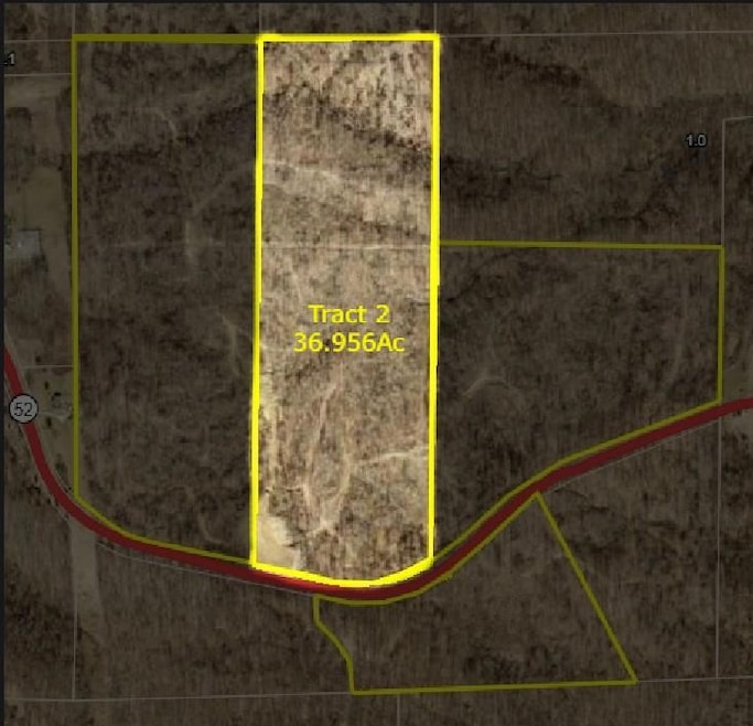
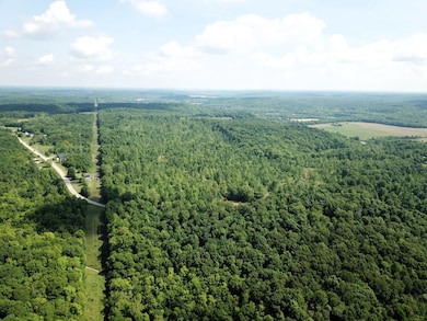
Explore the possibilities with this 36.956-acre tract located near historic Metamora, Indiana. As part of a larger 110-acre offering, this parcel can be purchased on its own or combined with adjoining tracts to create your ideal layout. Timber has been selectively harvested to reveal multiple potential building sites while preserving the property's natural character. Wildlife signs are abundant, making this an excellent choice for recreational use or a secluded residence. A shared road maintenance agreement with neighboring tracts to the north and west provides access. Peaceful, private, and full of potential Tract 2 is ready for your plans. Tracts are proposed splits, acreage can be adjusted at buyers discretion.

Listing Agent

Jonathan White

Whites Realty Listed on: 07/17/2025

Property Details

Property Type

  • Land

Est. Annual Taxes

  • $9

Lot Details

  • 36.96 Acre Lot
  • Property fronts an easement
  • Lot Has A Rolling Slope
  • Partially Wooded Lot
  • Property is zoned AGRI

Parking

  • Driveway

Utilities

  • Natural Gas Not Available
  • Not Connected to Water Source
  • Sewer Not Available

Community Details

  • Southeastern Indiana Board Association

Listing and Financial Details

  • Assessor Parcel Number 008007013100

Property Details

Property Type

Land

Est. Annual Taxes

$9

Lot Details

0

Listing Details

  • Property Sub Type: Acreage
  • FILLACRES: 36.9560
  • Allow On Internet: Yes
  • Lot Measurement: Acres
  • Prop. Type: Land
  • Property Ownership: Consumer
  • Public Listing Url: https://seibr.rapmls.com/scripts/mgrqispi.dll?APPNAME=seindiana&PRGNAME=MLSLogin&ARGUMENT=Pm9hduPBkA1zpWoHcqfQhdUuIbN0YHzKOG95jJe7lms=&KeyRid=1
  • Special Features: None

Interior Features

  • Other Tax Parcel ID: 008007013100

Exterior Features

  • Topography: ROLL
  • Easements: Driveway, Ingress/Egress, Utility

Utilities

  • Gas Company: None
  • Sewer: None
  • Water Source: None

Condo/Co-op/Association

  • Association: Southeastern Indiana Board

Schools

  • School District: Franklin County
  • School District: Franklin County

Lot Info

  • Lot Dimensions: 36.956
  • Lot Size Sq Ft: 1609803.00
  • Wooded: Partially
  • Zoning: AGRI

Tax Info

  • Semi Annual Taxes: 760
  • Tax Exemptions: None

MLS Schools

  • School Type: Elementary School
  • School Name: Laurel School
  • School Type: High School
  • School Name: Franklin County High

Map

Range of Values:

Collateral Analytics

Collateral Analytics Collateral Analytics AVMs (Automated Valuation Model) employ a number of statistical approaches combined with neighborhood-specific comparable selection guarantees the most up-to-date and precise valuations.

Not Available

Collateral Analytics does not have data for the current month. Please view the chart for historical values.

ICE

ICE Mortgage Technology ICE Mortgage Technology’s AVM (Automated Valuation Model) is a state-of-the-art online residential property valuation tool that provides a quick and accurate estimate of the value of almost any home in the U.S.

Not Available

ICE Mortgage Technology does not have data for the current month. Please view the chart for historical values.

First American

First American First American Data & Analytics’ next-generation AVM combines unrivaled data assets with a blended ensemble of valuation models to produce highly accurate, reliable valuations you can trust.

Not Available

First American does not have data for the current month. Please view the chart for historical values.

Quantarium

Quantarium Quantarium’s valuation service, repeatedly proven the industry’s most accurate and comprehensive, is supercharged with a self-learning and auto-tuning AI engine that continually becomes smarter and more accurate as it processes daily inputs from the industry’s leading RE data lake.

Not Available

Quantarium does not have data for the current month. Please view the chart for historical values.

Average Value
Not Available
List Price
Sold Price
Create a Home Valuation Report for This Property
The Home Valuation Report is an in-depth analysis detailing your home's value as well as a comparison with similar homes in the area

Home Values in the Area

Source: Public Records

Average Home Value in this Area


Source: Public Records

Tax History

Year Tax Paid Tax Assessment Tax Assessment Total Assessment is a certain percentage of the fair market value that is determined by local assessors to be the total taxable value of land and additions on the property. Land Improvement
2024 $9 $600 $600 $0
2023 $9 $600 $600 $0
2022 $28 $1,800 $1,800 $0
2021 $31 $1,900 $1,900 $0
2020 $29 $1,900 $1,900 $0
2019 $27 $1,800 $1,800 $0
2018 $26 $1,800 $1,800 $0
2017 $26 $1,700 $1,700 $0
2016 $5 $100 $100 $0
2014 $1 $100 $100 $0
2013 $1 $100 $100 $0
Source: Public Records

Property History

Date Event Price Change Sq Ft Price
07/17/2025 07/17/25 For Sale $275,000 -- --
Source: Southeastern Indiana Board of REALTORS®

Similar Property in Laurel, IN

  • 0 Old Us 52 Rd Unit LotWP001 23615955, Laurel, IN 47024

    $244,300

    • Land
    • 34.9 Acres
    • $7,000 per Acre
    • 0 Old Us 52 Rd
    • Unit LotWP001 23615955
    • Laurel, IN

    Wooded acreage near Laurel, IN, with great access and hunting potential! Along Old 52, you can access the "bottom" of this property where electricity is nearby. There is a nice, cleared area that would make a great location for a cabin or potential home. Red Oak Lane gives further access along the north edge of the property. The "top" has a large opening previously used as a food plot, which

    Tyler Fritz

    Section Image

Source: Southeastern Indiana Board of REALTORS®

MLS Number: 205485

Southeastern Indiana Board of REALTORS®

APN: 24-02-33-100-004.000-010