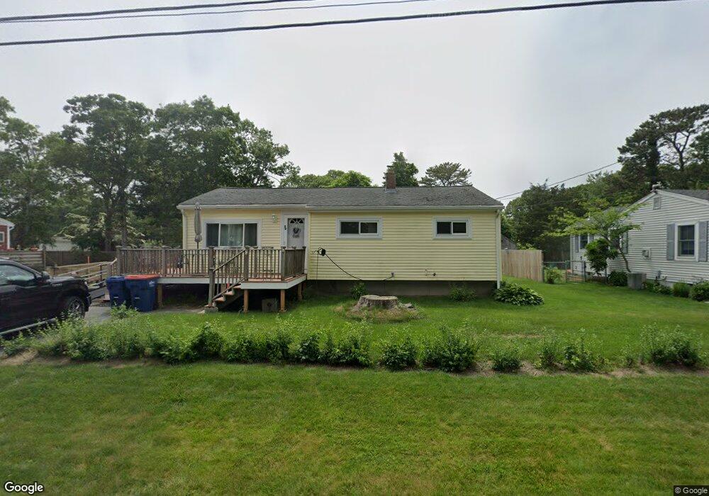
20 Arrowhead Dr Buzzards Bay, MA 02532
Estimated Value: $443,202 - $506,000
3
Beds
1
Bath
902
Sq Ft
$511/Sq Ft
Est. Value
About This Home
This home is located at 20 Arrowhead Dr, Buzzards Bay, MA 02532 and is currently estimated at $461,301, approximately $511 per square foot. 20 Arrowhead Dr is a home.
Ownership History
Date
Name
Owned For
Owner Type
Purchase Details
Closed on
Jul 24, 2018
Sold by
King Donald P and King Deborah F
Bought by
King Ft and King
Current Estimated Value
Purchase Details
Closed on
Feb 23, 2018
Sold by
King Ft and King
Bought by
King Deborah F and King Donald P
Purchase Details
Closed on
Jun 19, 2007
Sold by
King Donald P and King Deborah F
Bought by
King Ft and King Shayne P
Create a Home Valuation Report for This Property
The Home Valuation Report is an in-depth analysis detailing your home's value as well as a comparison with similar homes in the area
Purchase History
| Date | Buyer | Sale Price | Title Company |
|---|---|---|---|
| King Ft | -- | -- | |
| King Ft | -- | -- | |
| King Deborah F | -- | -- | |
| King Deborah F | -- | -- | |
| King Ft | -- | -- | |
| King Ft | -- | -- |
Source: Public Records
Mortgage History
| Date | Status | Borrower | Loan Amount |
|---|---|---|---|
| Previous Owner | King Ft | $75,000 | |
| Previous Owner | King Ft | $105,000 | |
| Previous Owner | King Ft | $57,500 |
Source: Public Records
Tax History
| Year | Tax Paid | Tax Assessment Tax Assessment Total Assessment is a certain percentage of the fair market value that is determined by local assessors to be the total taxable value of land and additions on the property. | Land | Improvement |
|---|---|---|---|---|
| 2025 | $3,942 | $359,000 | $118,000 | $241,000 |
| 2024 | $3,839 | $328,700 | $91,400 | $237,300 |
| 2023 | $3,453 | $294,700 | $83,100 | $211,600 |
| 2022 | $3,453 | $253,500 | $83,100 | $170,400 |
| 2021 | $3,441 | $245,800 | $83,100 | $162,700 |
| 2020 | $3,193 | $232,900 | $83,100 | $149,800 |
| 2019 | $2,875 | $212,000 | $77,600 | $134,400 |
| 2018 | $2,738 | $195,000 | $77,600 | $117,400 |
| 2017 | $2,556 | $182,800 | $77,600 | $105,200 |
| 2016 | $2,323 | $164,900 | $74,300 | $90,600 |
| 2015 | $2,259 | $164,900 | $74,300 | $90,600 |
| 2014 | $2,177 | $163,800 | $74,300 | $89,500 |
Source: Public Records
Map
Nearby Homes
- 3132 Cranberry Hwy Unit 59
- 60 Martin St
- 67 Algonquin St
- 92 Choctaw Dr
- 13 Bay Pointe Drive Extension
- 13 Bay Pointe Drive Extension Unit 13
- 29 Wenonah Rd
- 22 Long Neck Rd
- 29 Wenonah Rd
- 3 Fairway Dr Unit F
- 1 Downey St
- 23 Starboard Dr Unit Lot 50
- 36B Starboard Dr Unit 36E
- 36B Starboard Dr Unit 36G
- 36B Starboard Dr Unit 36C
- 36B Starboard Dr Unit 36A
- 36B Starboard Dr Unit 36D
- 36B Starboard Dr Unit 36B
- 36B Starboard Dr Unit 36F
- 36B Starboard Dr Unit 36H
- 22 Arrowhead Dr
- 18 Arrowhead Dr
- 3132 Cranberry Hwy Unit 36
- 3132 Cranberry Hwy Unit 16
- 3132 Cranberry Hwy Unit 12
- 3132 Cranberry Hwy Unit 44
- 3132 Cranberry Hwy
- 3132 Cranberry Hwy Unit 55
- 3132 Cranberry Hwy Unit 15
- 3132 Cranberry Hwy Unit 43
- 3132 Cranberry Hwy Unit 54
- 3132 Cranberry Hwy Unit 7
- 3132 Cranberry Hwy Unit 9
- 3132 Cranberry Hwy Unit 42
- 3132 Cranberry Hwy Unit 56
- 3132 Cranberry Hwy Unit 13 Jenifer
- 3132 Cranberry Hwy Unit 1
- 3132 Cranberry Hwy Unit 49
- 68 Ryder St
- 24 Arrowhead Dr
Your Personal Tour Guide
Ask me questions while you tour the home.