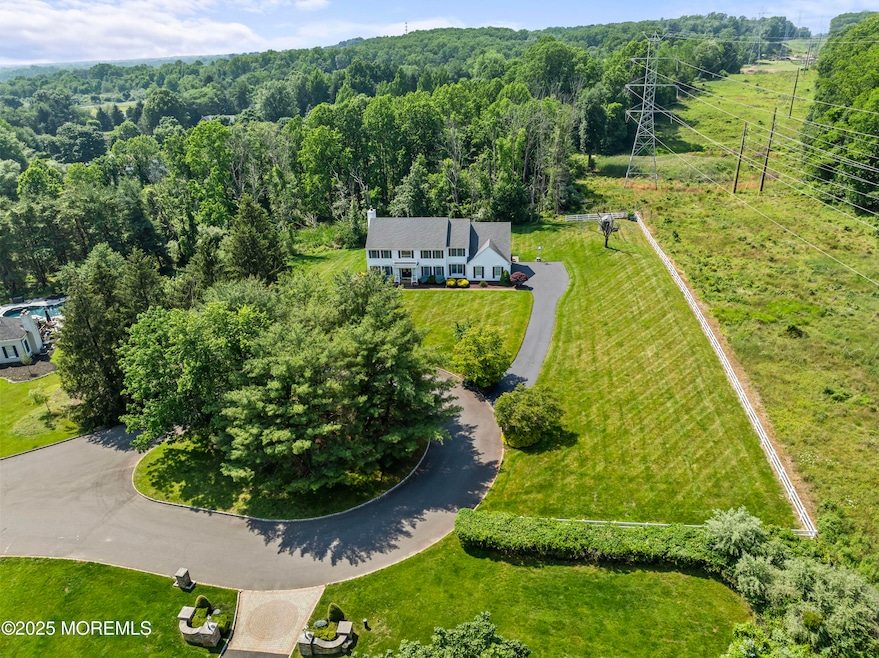
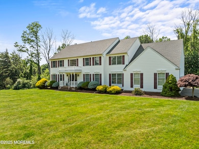


20 Birch Ln Colts Neck, NJ 07722
Estimated payment $6,857/month
Highlights
- New Kitchen
- Colonial Architecture
- Deck
- Conover Road School Rated A
- Atrium Room
- Adjacent to Greenbelt
About This Home
This stunning estate features approximately 3700 plus sq.ft of unparalleled luxury, space and privacy in one of Colts Neck's most desirable neighborhoods! While bordered by electrical power lines at the rear, this detail is outweighed by the homes expansive design, exquisite finishes and tranquil outdoor spaces. The large, open rooms, gourmet kitchen and serene primary suite are perfect for both everyday living and entertaining. The private backyard offers a peaceful retreat, while the property size and layout ensure privacy and value. Experience the best of luxury living! Great Community and Great Schools! This is an opportunity not to be missed!
Listing Agent
Keller Williams Realty Central Monmouth License #0019236 Listed on: 06/20/2025

Home Details
Home Type
- Single Family
Est. Annual Taxes
- $14,438
Year Built
- Built in 1993
Lot Details
- 1.26 Acre Lot
- Adjacent to Greenbelt
- Cul-De-Sac
- Street terminates at a dead end
Parking
- 3 Car Direct Access Garage
- Garage Door Opener
Home Design
- Colonial Architecture
- A-Frame Home
- Asphalt Rolled Roof
Interior Spaces
- 3,772 Sq Ft Home
- 2-Story Property
- Central Vacuum
- Crown Molding
- Vaulted Ceiling
- Ceiling Fan
- Skylights
- Recessed Lighting
- Light Fixtures
- Gas Fireplace
- Blinds
- Bay Window
- Double Door Entry
- Sliding Doors
- Family Room
- Sitting Room
- Living Room
- Dining Room
- Atrium Room
- Center Hall
- Unfinished Basement
- Basement Fills Entire Space Under The House
- Storm Windows
- Attic
Kitchen
- New Kitchen
- Breakfast Area or Nook
- Eat-In Kitchen
- Breakfast Bar
- Built-In Oven
- Gas Cooktop
- Stove
- Microwave
- Dishwasher
- Kitchen Island
Flooring
- Wood
- Concrete
- Ceramic Tile
Bedrooms and Bathrooms
- 5 Bedrooms
- Main Floor Bedroom
- Primary bedroom located on second floor
- Walk-In Closet
- 3 Full Bathrooms
- Dual Vanity Sinks in Primary Bathroom
- Whirlpool Bathtub
- Primary Bathroom includes a Walk-In Shower
Laundry
- Laundry Room
- Dryer
- Washer
Eco-Friendly Details
- Energy-Efficient Appliances
- Energy-Efficient Thermostat
Outdoor Features
- Balcony
- Deck
- Shed
- Storage Shed
- Porch
Schools
- Conover Road Elementary School
- Cedar Drive Middle School
- Freehold Regional High School
Utilities
- Forced Air Zoned Heating and Cooling System
- Heating System Uses Natural Gas
- Thermostat
- Power Generator
- Well
- Natural Gas Water Heater
- Septic Tank
- Septic System
Community Details
- No Home Owners Association
- Hills Gait Subdivision
Listing and Financial Details
- Exclusions: Owner's Personal Property and Belongings.
- Assessor Parcel Number 10-00006-0000-00009-16
Map
Home Values in the Area
Average Home Value in this Area
Tax History
| Year | Tax Paid | Tax Assessment Tax Assessment Total Assessment is a certain percentage of the fair market value that is determined by local assessors to be the total taxable value of land and additions on the property. | Land | Improvement |
|---|---|---|---|---|
| 2025 | $14,438 | $1,064,000 | $488,100 | $575,900 |
| 2024 | $13,719 | $969,000 | $428,100 | $540,900 |
| 2023 | $13,719 | $881,700 | $370,400 | $511,300 |
| 2022 | $12,412 | $770,700 | $320,400 | $450,300 |
| 2021 | $12,412 | $710,900 | $285,400 | $425,500 |
| 2020 | $12,008 | $680,700 | $270,400 | $410,300 |
| 2019 | $13,989 | $794,400 | $354,100 | $440,300 |
| 2018 | $13,683 | $770,900 | $336,100 | $434,800 |
| 2017 | $13,540 | $765,400 | $336,100 | $429,300 |
| 2016 | $13,190 | $762,000 | $336,100 | $425,900 |
| 2015 | $13,169 | $759,000 | $344,100 | $414,900 |
| 2014 | $13,169 | $780,600 | $388,000 | $392,600 |
Property History
| Date | Event | Price | List to Sale | Price per Sq Ft |
|---|---|---|---|---|
| 11/07/2025 11/07/25 | Pending | -- | -- | -- |
| 10/25/2025 10/25/25 | Price Changed | $1,075,000 | -2.3% | $285 / Sq Ft |
| 08/11/2025 08/11/25 | Price Changed | $1,100,000 | -4.3% | $292 / Sq Ft |
| 07/15/2025 07/15/25 | Price Changed | $1,150,000 | -4.2% | $305 / Sq Ft |
| 06/20/2025 06/20/25 | For Sale | $1,199,999 | -- | $318 / Sq Ft |
Purchase History
| Date | Type | Sale Price | Title Company |
|---|---|---|---|
| Deed | $540,000 | -- | |
| Deed | $387,500 | -- |
Mortgage History
| Date | Status | Loan Amount | Loan Type |
|---|---|---|---|
| Open | $432,000 | No Value Available | |
| Previous Owner | $125,000 | No Value Available |
Source: MOREMLS (Monmouth Ocean Regional REALTORS®)
MLS Number: 22518245
APN: 10-00006-0000-00009-16
Disclaimer: Certain information contained herein is derived from information provided by parties other than Homes.com. All information provided is deemed reliable, but is not guaranteed to be accurate and should be independently verified.
![]() IDX information is provided exclusively for personal, non-commercial use, and may not be used for any purpose other than to identify prospective properties consumers may be interested in purchasing.
IDX information is provided exclusively for personal, non-commercial use, and may not be used for any purpose other than to identify prospective properties consumers may be interested in purchasing.
Information is deemed reliable but not guaranteed.
- 12 Crest Dr
- 88 Clover Hill Rd
- 15 Windsor Place
- 9 Mulberry Ln
- 39 Mountainside Dr
- 3 Colts Gait Ln
- 5 Osprey Ct
- 202 Shore Ct
- 18 Egret Ln
- 203 Shore Ct
- 1304 Shore Ct
- 680 - 21.04 County Road 520
- 680 - 21.1 County Road 520
- 680 - 21.21 County Road 520
- 680 County Road 520
- 680 - 21.15 County Road 520
- 680 - 21.19 County Road 520
- 680 - 21.11 County Road 520
- 680 - 21.12 County Road 520
- 680 - 21.09 County Road 520