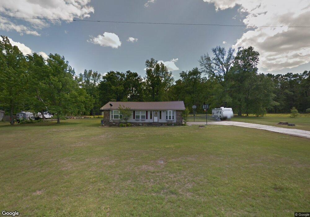
20 Brents Rd Oppelo, AR 72110
Estimated Value: $116,688 - $194,000
Studio
1
Bath
1,344
Sq Ft
$105/Sq Ft
Est. Value
About This Home
This home is located at 20 Brents Rd, Oppelo, AR 72110 and is currently estimated at $140,922, approximately $104 per square foot. 20 Brents Rd is a home located in Conway County with nearby schools including Morrilton Primary School, Morrilton Elementary School, and Morrilton Intermediate School.
Ownership History
Date
Name
Owned For
Owner Type
Purchase Details
Closed on
Aug 21, 2025
Sold by
Waters Bennie C and Waters Alisha
Bought by
Guerrero Raul
Current Estimated Value
Purchase Details
Closed on
Aug 15, 2002
Bought by
Waters Bennie C and Waters Jr
Purchase Details
Closed on
Jun 5, 1998
Bought by
Andrews Kevin
Purchase Details
Closed on
Feb 28, 1995
Bought by
Andrews Kevin and Andrews Roxana
Create a Home Valuation Report for This Property
The Home Valuation Report is an in-depth analysis detailing your home's value as well as a comparison with similar homes in the area
Purchase History
| Date | Buyer | Sale Price | Title Company |
|---|---|---|---|
| Guerrero Raul | -- | Benchmark Title | |
| Waters Bennie C | $50,000 | -- | |
| Andrews Kevin | -- | -- | |
| Andrews Kevin | $40,000 | -- |
Source: Public Records
Mortgage History
| Date | Status | Borrower | Loan Amount |
|---|---|---|---|
| Previous Owner | Andrews Kevin | $6,555 |
Source: Public Records
Tax History
| Year | Tax Paid | Tax Assessment Tax Assessment Total Assessment is a certain percentage of the fair market value that is determined by local assessors to be the total taxable value of land and additions on the property. | Land | Improvement |
|---|---|---|---|---|
| 2025 | $75 | $16,450 | $1,300 | $15,150 |
| 2024 | $149 | $16,450 | $1,300 | $15,150 |
| 2023 | $143 | $15,380 | $1,300 | $14,080 |
| 2022 | $165 | $15,380 | $1,300 | $14,080 |
| 2021 | $141 | $9,540 | $1,400 | $8,140 |
| 2020 | $141 | $9,540 | $1,400 | $8,140 |
| 2019 | $141 | $9,540 | $1,400 | $8,140 |
| 2018 | $166 | $9,540 | $1,400 | $8,140 |
| 2017 | $166 | $9,540 | $1,400 | $8,140 |
| 2016 | $198 | $10,270 | $1,600 | $8,670 |
| 2015 | $158 | $10,270 | $1,600 | $8,670 |
| 2014 | $153 | $10,270 | $1,600 | $8,670 |
Source: Public Records
Map
Nearby Homes
- 21 Brents Rd
- 249 Arkansas 9
- 22 Tanglewood Ave
- 23 Bryant Ave
- 308 5th Ave
- 394 Copperas Gap Rd
- 15 Glory Ln
- 10-4N-17W Fourche Ave
- 99 Sandtown Rd
- 00 S Burrow St
- 903 & 905 S Moose St
- 901 & 902 S Moose St
- 750 Mountain St
- 67 Turkey Run Loop
- 13 Eugenia St
- 400 W Bennett St
- 9 W Winthrop Rd
- 918 Ezell St
- 401 S Moose St
- 53 64 75 Pawpaw Bend Rd
Your Personal Tour Guide
Ask me questions while you tour the home.