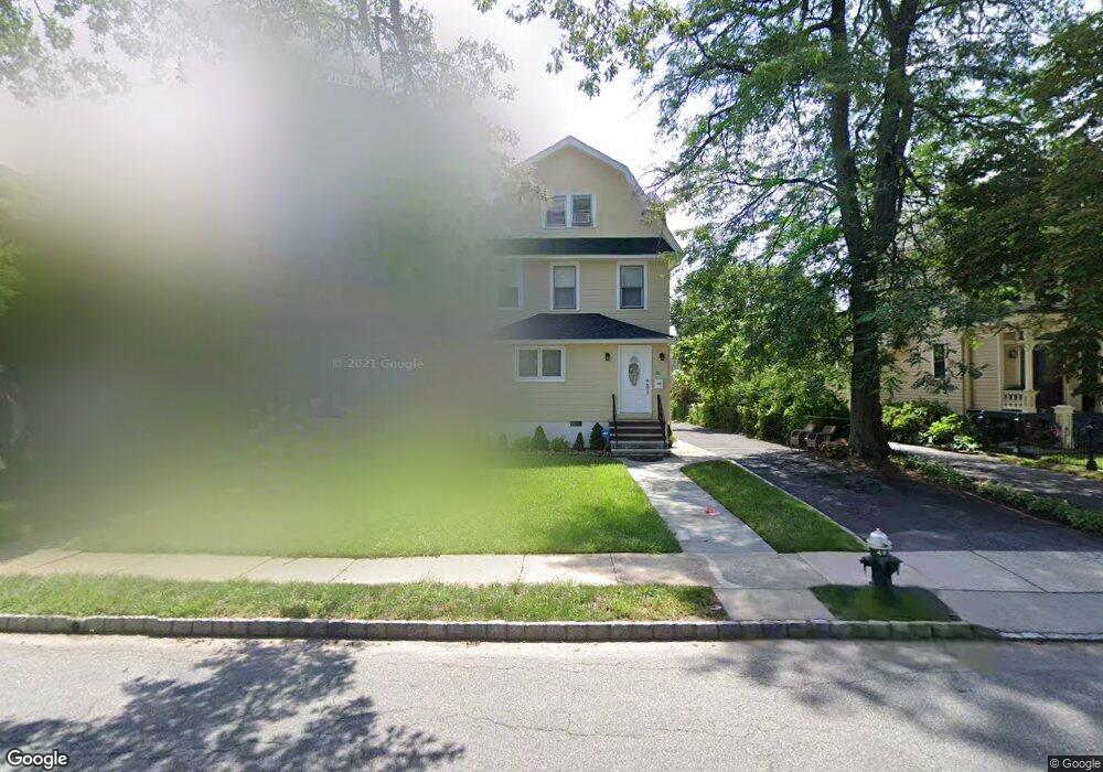
20 Brookfield Rd Montclair, NJ 07043
Estimated Value: $1,010,000 - $1,230,000
2
Beds
1
Bath
2,449
Sq Ft
$448/Sq Ft
Est. Value
About This Home
This home is located at 20 Brookfield Rd, Montclair, NJ 07043 and is currently estimated at $1,096,312, approximately $447 per square foot. 20 Brookfield Rd is a home located in Essex County with nearby schools including Bradford School, Hillside School, and Nishuane School.
Ownership History
Date
Name
Owned For
Owner Type
Purchase Details
Closed on
May 23, 2005
Sold by
Robles Cesar
Bought by
Rodio Daniel and Rodio Patricia
Current Estimated Value
Home Financials for this Owner
Home Financials are based on the most recent Mortgage that was taken out on this home.
Original Mortgage
$574,000
Interest Rate
5.78%
Mortgage Type
Adjustable Rate Mortgage/ARM
Purchase Details
Closed on
Jul 22, 1999
Sold by
Lionetti Frank
Bought by
Robles Cesar and Robles Gustavo
Home Financials for this Owner
Home Financials are based on the most recent Mortgage that was taken out on this home.
Original Mortgage
$251,750
Interest Rate
7.53%
Create a Home Valuation Report for This Property
The Home Valuation Report is an in-depth analysis detailing your home's value as well as a comparison with similar homes in the area
Home Values in the Area
Average Home Value in this Area
Purchase History
| Date | Buyer | Sale Price | Title Company |
|---|---|---|---|
| Rodio Daniel | $574,000 | -- | |
| Robles Cesar | $265,000 | -- |
Source: Public Records
Mortgage History
| Date | Status | Borrower | Loan Amount |
|---|---|---|---|
| Previous Owner | Rodio Daniel | $574,000 | |
| Previous Owner | Robles Cesar | $251,750 |
Source: Public Records
Tax History Compared to Growth
Tax History
| Year | Tax Paid | Tax Assessment Tax Assessment Total Assessment is a certain percentage of the fair market value that is determined by local assessors to be the total taxable value of land and additions on the property. | Land | Improvement |
|---|---|---|---|---|
| 2025 | $17,475 | $517,000 | $299,800 | $217,200 |
| 2024 | $17,475 | $517,000 | $299,800 | $217,200 |
| 2022 | $16,999 | $517,000 | $299,800 | $217,200 |
| 2021 | $16,704 | $517,000 | $299,800 | $217,200 |
| 2020 | $16,435 | $517,000 | $299,800 | $217,200 |
| 2019 | $16,265 | $517,000 | $299,800 | $217,200 |
| 2018 | $15,996 | $517,000 | $299,800 | $217,200 |
| 2017 | $16,108 | $431,400 | $244,900 | $186,500 |
| 2016 | $15,677 | $431,400 | $244,900 | $186,500 |
| 2015 | $15,211 | $431,400 | $244,900 | $186,500 |
| 2014 | $14,702 | $431,400 | $244,900 | $186,500 |
Source: Public Records
Map
Nearby Homes
- 422 Valley Rd
- 82 Watchung Ave Unit 84
- 86 Watchung Ave Unit 2
- 86 Watchung Ave Unit 1
- 35 Watchung Ave
- 17 Parkway
- 530 Valley Rd Unit C002B
- 530 Valley Rd Unit 2B
- 306 N Mountain Ave
- 215 Upper Mountain Ave
- 28 Waterbury Rd
- 253 Midland Ave
- 401 N Fullerton Ave
- 189 Upper Mountain Ave
- 98 Wildwood Ave
- 24 Club Way
- 372 Up Mountain Ave
- 163 Park St
- 16 Brookfield Rd
- 24 Brookfield Rd
- 14 Brookfield Rd
- 26 Brookfield Rd
- 12 Brookfield Rd
- 28 Brookfield Rd
- 4 Appleton Place
- 2 Appleton Place
- 6 Appleton Place
- 10 Brookfield Rd
- 30 Brookfield Rd
- 8 Appleton Place
- 17 Brookfield Rd
- 17 Brookfield Rd Unit 1
- 10 Appleton Place
- 19 Brookfield Rd
- 32 Brookfield Rd
- 32 Brookfield Rd Unit 2
- 15 Brookfield Rd
- 15 Brookfield Rd Unit 1