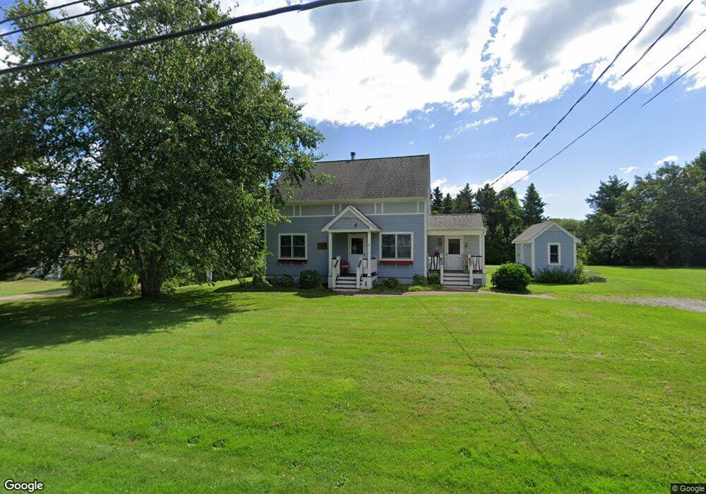
20 Brownell Rd Little Compton, RI 02837
Estimated Value: $752,635 - $902,000
2
Beds
2
Baths
1,622
Sq Ft
$507/Sq Ft
Est. Value
About This Home
This home is located at 20 Brownell Rd, Little Compton, RI 02837 and is currently estimated at $822,159, approximately $506 per square foot. 20 Brownell Rd is a home located in Newport County with nearby schools including Wilbur & McMahon School.
Ownership History
Date
Name
Owned For
Owner Type
Purchase Details
Closed on
Jul 30, 2014
Sold by
Ohalloran Kathleen A
Bought by
Ohalloran Tr Kathleen A and Kathleen A Ohalloran T
Current Estimated Value
Purchase Details
Closed on
Apr 3, 2000
Sold by
Lewis Manuel C and Lewis Sandra
Bought by
Ohalloran Kathleen A
Create a Home Valuation Report for This Property
The Home Valuation Report is an in-depth analysis detailing your home's value as well as a comparison with similar homes in the area
Home Values in the Area
Average Home Value in this Area
Purchase History
| Date | Buyer | Sale Price | Title Company |
|---|---|---|---|
| Ohalloran Tr Kathleen A | -- | -- | |
| Ohalloran Kathleen A | $110,000 | -- | |
| Ohalloran Tr Kathleen A | -- | -- | |
| Ohalloran Kathleen A | $110,000 | -- |
Source: Public Records
Mortgage History
| Date | Status | Borrower | Loan Amount |
|---|---|---|---|
| Open | Ohalloran Kathleen A | $276,500 | |
| Previous Owner | Ohalloran Kathleen A | $50,000 | |
| Previous Owner | Ohalloran Kathleen A | $129,000 |
Source: Public Records
Tax History
| Year | Tax Paid | Tax Assessment Tax Assessment Total Assessment is a certain percentage of the fair market value that is determined by local assessors to be the total taxable value of land and additions on the property. | Land | Improvement |
|---|---|---|---|---|
| 2025 | $2,897 | $604,900 | $196,100 | $408,800 |
| 2024 | $2,631 | $517,900 | $170,400 | $347,500 |
| 2023 | $2,569 | $517,900 | $170,400 | $347,500 |
| 2022 | $2,538 | $517,900 | $170,400 | $347,500 |
| 2021 | $2,840 | $470,200 | $142,500 | $327,700 |
| 2020 | $2,708 | $452,100 | $142,500 | $309,600 |
| 2019 | $2,681 | $452,100 | $142,500 | $309,600 |
| 2018 | $2,200 | $369,200 | $142,500 | $226,700 |
| 2016 | $2,093 | $369,200 | $142,500 | $226,700 |
| 2015 | $2,201 | $382,700 | $129,600 | $253,100 |
| 2014 | $2,158 | $382,700 | $129,600 | $253,100 |
Source: Public Records
Map
Nearby Homes
- 128 Maple Ave
- 141 S Of Commons Rd
- 89 S Shore Rd
- 30 Indian Rd
- 49 Ocean Dr
- 138 Willow Ave
- 0 Willow Ave
- 38 Old Bull Ln
- 505 Long Hwy
- 255 John Dyer Rd
- 141 Peckham Rd
- 441 W Main Rd
- 180 W Main Rd
- 245 John Dyer Rd
- 140I Long Hwy
- 140 Long Hwy
- 17 Ferolbink Way
- 1 Puddingstone Cir
- 155 W Main Rd
- 116 Amy Hart Path
Your Personal Tour Guide
Ask me questions while you tour the home.