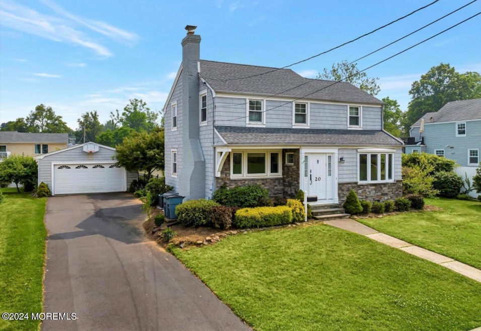
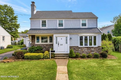
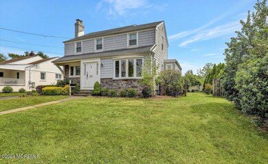
20 Clarence Ave Long Branch, NJ 07740
Estimated payment $7,885/month
Highlights
- Colonial Architecture
- No HOA
- 2 Car Garage
- Deck
- Central Air
- 3-minute walk to Van Court Park
About This Home
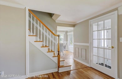
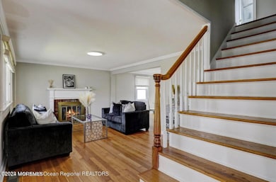
Close to the Beach, and between WESTWOOD- NORWOOD- & PARK Avenues, come see this MOVE-IN Ready COLONIAL featuring sun-filled living spaces, a formal dining room, dinette, living room, granite/stainless kitchen, and a SPACIOUS DEN! Quality construction, thoughtful layout, and a true sense of HOME throughout. Above the den offers a RARE and SIMPLE opportunity to expand an extra bedroom and bathroom. ROOM FOR POOL! Available for SUMMER 2026 occupancy. Turnkey values at this price point in ELBERON DO NOT COME OFTEN! Forever be the owner, and CALL TODAY!
Home Details
Home Type
- Single Family
Est. Annual Taxes
- $16,019
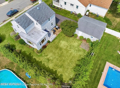
Lot Details
- 7,405 Sq Ft Lot
- Lot Dimensions are 75 x 100
Parking
- 2 Car Garage
Home Design
- Colonial Architecture
- Shingle Roof
Interior Spaces
- 1,658 Sq Ft Home
- 2-Story Property
- Unfinished Basement
Bedrooms and Bathrooms
- 3 Bedrooms
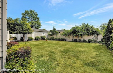
Outdoor Features
- Deck
Schools
- Long Branch Middle School
Utilities
- Central Air
- Heating System Uses Natural Gas
- Natural Gas Water Heater
Community Details
- No Home Owners Association
Listing and Financial Details
- Assessor Parcel Number 27-00067-0000-00004
Map
Home Values in the Area
Average Home Value in this Area
Tax History
| Year | Tax Paid | Tax Assessment Tax Assessment Total Assessment is a certain percentage of the fair market value that is determined by local assessors to be the total taxable value of land and additions on the property. | Land | Improvement |
|---|---|---|---|---|
| 2025 | $14,025 | $1,067,900 | $832,500 | $235,400 |
| 2024 | $13,002 | $912,500 | $687,300 | $225,200 |
| 2023 | $13,002 | $837,200 | $622,300 | $214,900 |
| 2022 | $10,505 | $591,500 | $366,300 | $225,200 |
| 2021 | $10,505 | $525,000 | $295,300 | $229,700 |
| 2020 | $10,256 | $490,700 | $262,300 | $228,400 |
| 2019 | $9,419 | $448,100 | $230,300 | $217,800 |
| 2018 | $8,697 | $411,400 | $201,600 | $209,800 |
| 2017 | $7,943 | $385,400 | $179,600 | $205,800 |
| 2016 | $7,965 | $394,100 | $193,600 | $200,500 |
| 2015 | $7,730 | $347,100 | $140,600 | $206,500 |
| 2014 | $7,222 | $341,800 | $158,600 | $183,200 |
Property History
| Date | Event | Price | List to Sale | Price per Sq Ft |
|---|---|---|---|---|
| 12/07/2025 12/07/25 | Price Changed | $1,249,000 | -7.5% | $753 / Sq Ft |
| 12/03/2025 12/03/25 | For Sale | $1,350,000 | -- | $814 / Sq Ft |
Purchase History
| Date | Type | Sale Price | Title Company |
|---|---|---|---|
| Deed | $585,000 | Trident Abstract Ttl Agcy Ll | |
| Quit Claim Deed | -- | -- |
Mortgage History
| Date | Status | Loan Amount | Loan Type |
|---|---|---|---|
| Open | $438,750 | New Conventional |
Source: MOREMLS (Monmouth Ocean Regional REALTORS®)
MLS Number: 22535874
APN: 27-00067-0000-00004
Disclaimer: Certain information contained herein is derived from information provided by parties other than Homes.com. All information provided is deemed reliable, but is not guaranteed to be accurate and should be independently verified.
![]() IDX information is provided exclusively for personal, non-commercial use, and may not be used for any purpose other than to identify prospective properties consumers may be interested in purchasing.
IDX information is provided exclusively for personal, non-commercial use, and may not be used for any purpose other than to identify prospective properties consumers may be interested in purchasing.
Information is deemed reliable but not guaranteed.
- 19 Clarence Ave
- 717 Norwood Ave
- 4 Clarence Ave
- 881 Red Oaks Dr
- 889 Red Oaks Dr
- 329 Yorke Ave
- 280 Cummings Ave
- 324 Cedar Ave
- 497 Norwood Ave
- 251 Highland Ave
- 497 Marvin Dr
- 250 Alpern Ave
- 8 Norwood Ct
- 3 Royal Place
- 211 Cedar Ave
- 448 Monmouth Place
- 266 Lenox Ave
- 489 Cedar Ave
- 251 Park Ave
- 73 Larchwood Ave
- 7 Elinore Ave
- 866 Red Oaks Dr
- 871 Red Oaks Dr
- 872 Red Oaks Dr
- 884 Red Oaks Dr
- 205 Alpern Ave
- 304 Cummings Ave
- 320 Oakley Ave
- 325 Oakley Ave
- 313 Yorke Ave
- 278 Lake Ave
- 279 Cummings Ave
- 348 Cedar Ave Unit 1
- 348 Cedar Ave Unit 3
- 301 Norgrove Place
- 297 Highland Ave
- 317 Jersey Ave
- 280 Oakley Ave
- 288 Cedar Ave
- 975 van Court Ave
