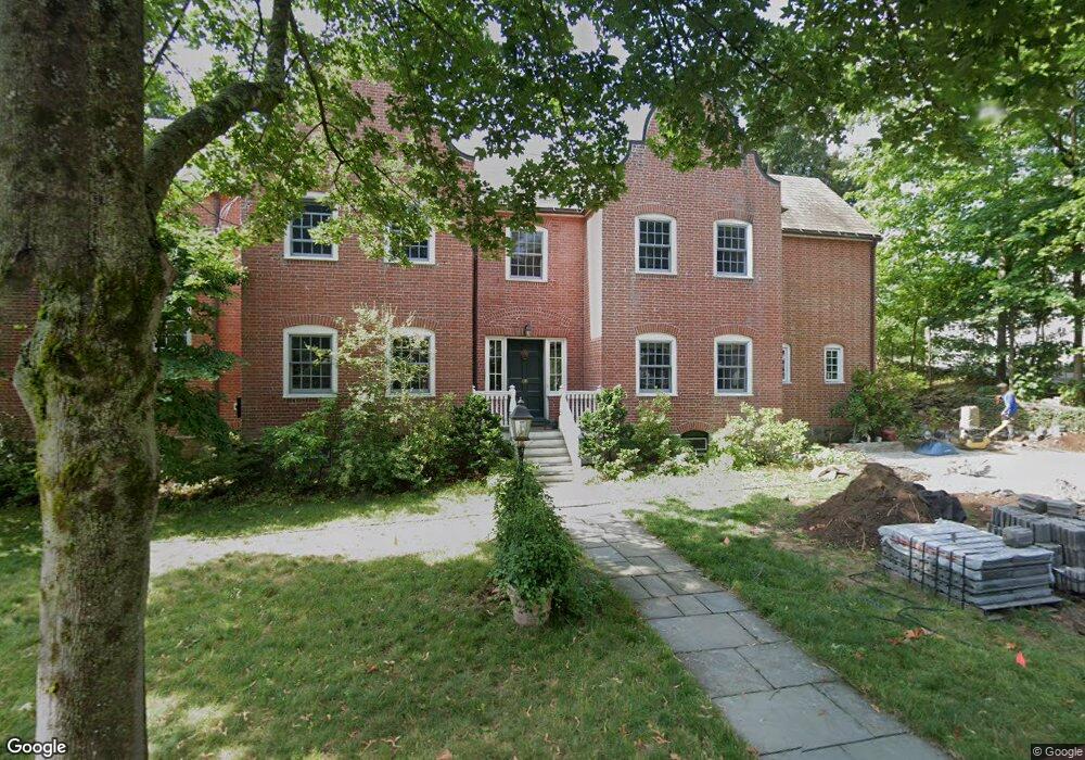
20 Devon Rd Newton Center, MA 02459
Newton Centre NeighborhoodEstimated Value: $2,700,565 - $3,031,000
6
Beds
6
Baths
4,372
Sq Ft
$667/Sq Ft
Est. Value
About This Home
This home is located at 20 Devon Rd, Newton Center, MA 02459 and is currently estimated at $2,917,391, approximately $667 per square foot. 20 Devon Rd is a home located in Middlesex County with nearby schools including Ward Elementary School, Mason Rice Elementary School, and Charles E Brown Middle School.
Ownership History
Date
Name
Owned For
Owner Type
Purchase Details
Closed on
Jun 1, 2000
Sold by
Gold Nancy M
Bought by
Dolan Simon P and Dolan Lucia
Current Estimated Value
Home Financials for this Owner
Home Financials are based on the most recent Mortgage that was taken out on this home.
Original Mortgage
$252,700
Interest Rate
8.14%
Mortgage Type
Purchase Money Mortgage
Create a Home Valuation Report for This Property
The Home Valuation Report is an in-depth analysis detailing your home's value as well as a comparison with similar homes in the area
Home Values in the Area
Average Home Value in this Area
Purchase History
| Date | Buyer | Sale Price | Title Company |
|---|---|---|---|
| Dolan Simon P | $1,175,000 | -- |
Source: Public Records
Mortgage History
| Date | Status | Borrower | Loan Amount |
|---|---|---|---|
| Open | Dolan Simon P | $252,000 | |
| Closed | Dolan Simon P | $252,700 |
Source: Public Records
Tax History
| Year | Tax Paid | Tax Assessment Tax Assessment Total Assessment is a certain percentage of the fair market value that is determined by local assessors to be the total taxable value of land and additions on the property. | Land | Improvement |
|---|---|---|---|---|
| 2025 | $26,453 | $2,699,300 | $1,203,200 | $1,496,100 |
| 2024 | $23,365 | $2,394,000 | $1,168,200 | $1,225,800 |
| 2023 | $21,715 | $2,133,100 | $890,500 | $1,242,600 |
| 2022 | $20,778 | $1,975,100 | $824,500 | $1,150,600 |
| 2021 | $20,049 | $1,863,300 | $777,800 | $1,085,500 |
| 2020 | $19,453 | $1,863,300 | $777,800 | $1,085,500 |
| 2019 | $6,581 | $1,809,000 | $755,100 | $1,053,900 |
| 2018 | $6,024 | $1,695,800 | $688,600 | $1,007,200 |
| 2017 | $17,790 | $1,599,800 | $649,600 | $950,200 |
| 2016 | $17,014 | $1,495,100 | $607,100 | $888,000 |
| 2015 | $16,223 | $1,397,300 | $567,400 | $829,900 |
Source: Public Records
Map
Nearby Homes
- 97 Montvale Rd
- 19 Chestnut Terrace
- 92 Grant Ave
- 8 Willow St Unit 10
- 524 Ward St
- 158 Langley Rd Unit 158
- 108 Glen Ave
- 17 Lancaster Rd
- 156 Langley Rd Unit 156
- 156 Langley Rd
- 5 Hammond St
- 26 Knowles St
- 5 Morseland Ave
- 6 Paul St Unit 2
- 22 Brackett Rd
- 60 Chapin Rd
- 66 Montrose St
- 929 Beacon St
- 60 Ashton Ave
- 61 Woodlawn Dr
Your Personal Tour Guide
Ask me questions while you tour the home.